EdwardWright-MapforSailingtoAzores-1599.jpg(477 × 518 εικονοστοιχεία, μέγεθος αρχείου: 96 KB, τύπος MIME: image/jpeg)

Σύνοψη

Περιγραφή
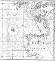
English: English mathematician and cartographer Edward Wright's map "for sailing to the Isles of Azores", which was constructed according to the Mercator projection which Wright explained in his work Certaine Errors of Navigation (1599). The star-like grid of lines are loxodromes or rhumb lines.
Ημερομηνία
Πηγή Edward Wright (1599) Certaine Errors in Navigation, arising either of the Ordinarie Erroneous Making or Vsing of the Sea Chart, Compasse, Crosse Staffe, and Tables of Declination of the Sunne, and Fixed Starres Detected and Corrected. (The Voyage of the Right Ho. George Earle of Cumberl. to the Azores, &c.), Λονδίνο: Printed ... by Valentine Simmes Reproduced as fig. 2.10 of Paul J. Lewi (2006-02-11) "Mercator, Wright and Mapmaking" in Speaking of Graphics: An Essay on Graphicacy in Science, Technology and Business, Turnhout, Belgium: DataScope, pp. 30
Δημιουργός Edward Wright

Αδειοδότηση

Public domain

Αυτό το έργο είναι κοινό κτήμα στη χώρα προέλευσής του και άλλες χώρες και περιοχές όπου η διάρκεια πνευματικών δικαιωμάτων είναι όσο η ζωή του δημιουργού και μέχρι 100 χρόνια μετά ή λιγότερο.


You must also include a United States public domain tag to indicate why this work is in the public domain in the United States.

Λεζάντες

Δεν ορίστηκε λεζάντα

Items portrayed in this file

απεικονίζει

Ιστορικό αρχείου

Κλικάρετε σε μια ημερομηνία/ώρα για να δείτε το αρχείο όπως εμφανιζόταν εκείνη τη στιγμή.

Ώρα/Ημερομ.ΜικρογραφίαΔιαστάσειςΧρήστηςΣχόλια
τελευταία16:45, 5 Μαΐου 2008Μικρογραφία για την έκδοση της 16:45, 5 Μαΐου 2008477 × 518 (96 KB)Jacklee==Summary== {{Information |Description = {{en|English mathematician and cartographer Edward Wright's map "for sailing to the Isles of Azores", which wa

Τα παρακάτω λήμματα συνδέουν σε αυτό το αρχείο:

Καθολική χρήση αρχείου

Τα ακόλουθα άλλα wiki χρησιμοποιούν αυτό το αρχείο:

Μεταδεδομένα