Αρχείο:HeimSachsen.png

Μέγεθος αυτής της προεπισκόπησης: 551 × 599 εικονοστοιχεία . Άλλες αναλύσεις: 221 × 240 εικονοστοιχεία | 441 × 480 εικονοστοιχεία | 881 × 958 εικονοστοιχεία.
Εικόνα σε υψηλότερη ανάλυση (881 × 958 εικονοστοιχεία, μέγεθος αρχείου: 346 KB, τύπος MIME: image/png)
|
|
Αυτό το αρχείο και η περιγραφή του προέρχονται από το Wikimedia Commons. Οι πληροφορίες από την σελίδα περιγραφής του εκεί εμφανίζονται παρακάτω. |

Σύνοψη
| Περιγραφή |
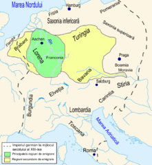
Română: Regiunile de provenienţă ale coloniştilor saşi în Transilvania în secolul al XIII-lea. |
| Ημερομηνία | |
| Πηγή | Th.Nagler - Asezarea saşilor în Transilvania - Bucureşti, Editura Kriterion, 1992, planşa X. |
| Δημιουργός | Asybaris |

|
This map image could be re-created using vector graphics as an SVG file. This has several advantages; see Commons:Media for cleanup for more information. If an SVG form of this image is available, please upload it and afterwards replace this template with
{{vector version available|new image name}}.
It is recommended to name the SVG file “HeimSachsen.svg”—then the template Vector version available (or Vva) does not need the new image name parameter. |
Αδειοδότηση
| Εγώ, ο κάτοχος των πνευματικών δικαιωμάτων αυτού του έργου, δημοσιεύω αυτό το έργο ως κοινό κτήμα. Αυτό ισχύει σε παγκόσμια κλίμακα. Σε ορισμένες χώρες αυτό μπορεί να μην είναι νομικά εφικτό. Αν ναι: Παραχωρώ σε οποιονδήποτε το δικαίωμα να χρησιμοποιήσει αυτό το έργο "για οποιονδήποτε σκοπό", χωρίς κανέναν όρο, εκτός και αν τέτοιοι όροι τίθενται από την νομοθεσία |
Ιστορικό αρχείου
Κλικάρετε σε μια ημερομηνία/ώρα για να δείτε το αρχείο όπως εμφανιζόταν εκείνη τη στιγμή.
| Ώρα/Ημερομ. | Μικρογραφία | Διαστάσεις | Χρήστης | Σχόλια | |
|---|---|---|---|---|---|
| τελευταία | 18:02, 13 Φεβρουαρίου 2009 | | 881 × 958 (346 KB) | Asybaris01 | corectii |
| 16:41, 13 Φεβρουαρίου 2009 |  | 881 × 958 (339 KB) | Asybaris01 | {{Information |Description={{ro|1=Regiunile de provenienţă ale coloniştilor saşi în Transilvania în secolul al XIII-lea.}} |Source=Th.Nagler - Asezarea saşilor în Transilvania - Bucureşti, Editura Kriterion, 1992, planşa X. |Author=[[:ro:Utiliz |
Συνδέσεις αρχείου
Τα παρακάτω λήμματα συνδέουν σε αυτό το αρχείο:
Καθολική χρήση αρχείου
Τα ακόλουθα άλλα wiki χρησιμοποιούν αυτό το αρχείο:
- Χρήση σε en.wikipedia.org
- Χρήση σε es.wikipedia.org
- Χρήση σε ro.wikipedia.org
- Χρήση σε sl.wikipedia.org