Αρχείο:Map of Greece 1903.png
Μέγεθος αυτής της προεπισκόπησης: 752 × 600 εικονοστοιχεία . Άλλες αναλύσεις: 301 × 240 εικονοστοιχεία | 602 × 480 εικονοστοιχεία | 963 × 768 εικονοστοιχεία | 1.280 × 1.020 εικονοστοιχεία | 2.560 × 2.041 εικονοστοιχεία | 3.472 × 2.768 εικονοστοιχεία.
Εικόνα σε υψηλότερη ανάλυση (3.472 × 2.768 εικονοστοιχεία, μέγεθος αρχείου: 15,57 MB, τύπος MIME: image/png)
|
|
Αυτό το αρχείο και η περιγραφή του προέρχονται από το Wikimedia Commons. Οι πληροφορίες από την σελίδα περιγραφής του εκεί εμφανίζονται παρακάτω. |
Σύνοψη
| Περιγραφή |
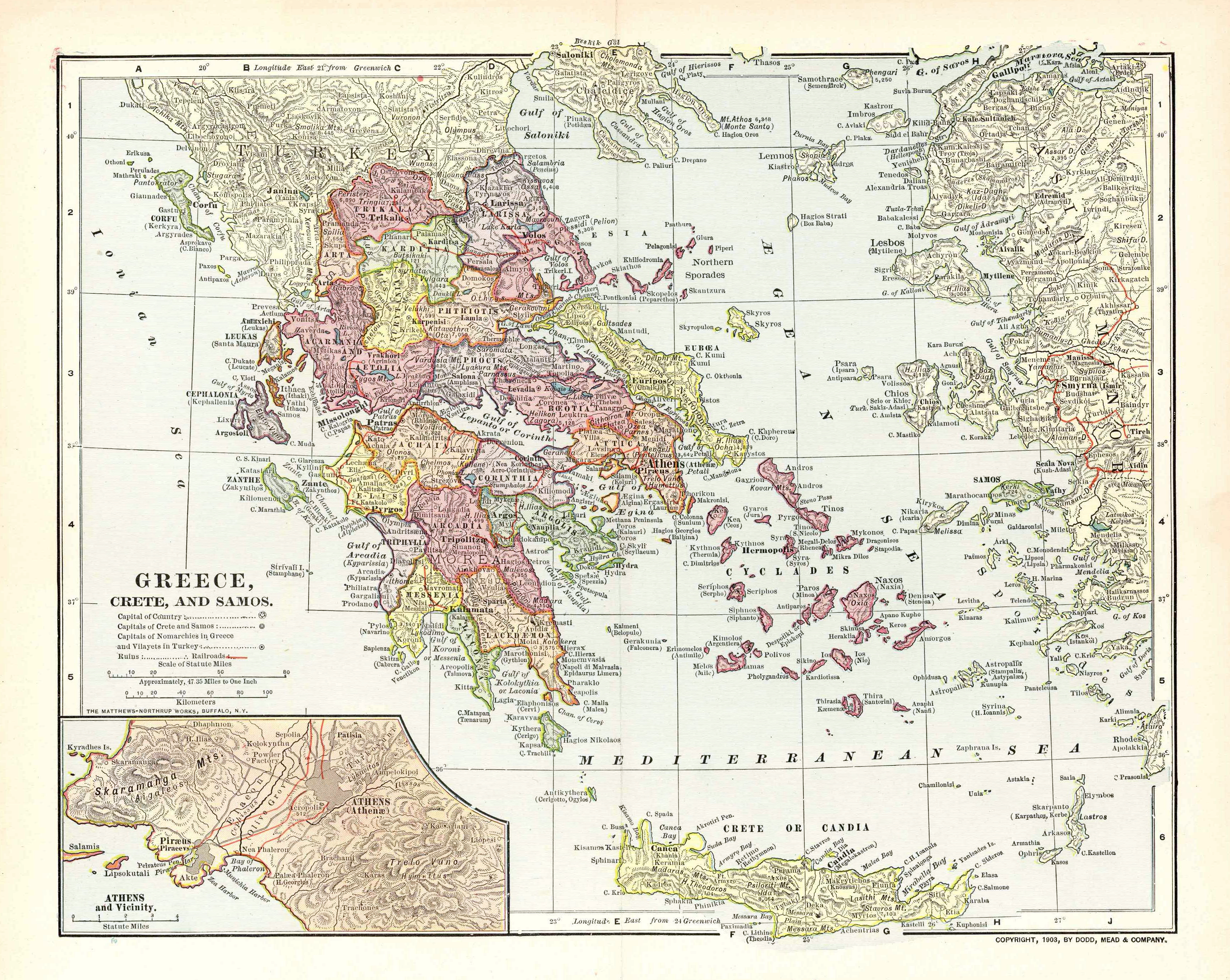
English: Map of the Kingdom of Greece, the Cretan State and the Principality of Samos in 1903. It displays the greek railway network as it was in 1900-1901. |
| Ημερομηνία | |
| Πηγή | Old map, own collection. Transferred from en.wikipedia to Commons by Sfan00_IMG using CommonsHelper. Original uploader was Sv1xv at en.wikipedia. |
| Δημιουργός | Unknown. Published by Dodd, Mead & Co. Printed by Mattheus-Northup Works, Buffalo, NY. |
| Άδεια (Επαναχρησιμοποίηση αυτού του αρχείου) |
PD-US |
| άλλες εκδόσεις |


Αδειοδότηση
This media file is in the public domain in the United States. This applies to U.S. works where the copyright has expired, often because its first publication occurred prior to January 1, 1929, and if not then due to lack of notice or renewal. See this page for further explanation.
|
 | |
 |
This image might not be in the public domain outside of the United States; this especially applies in the countries and areas that do not apply the rule of the shorter term for US works, such as Canada, Mainland China (not Hong Kong or Macao), Germany, Mexico, and Switzerland. The creator and year of publication are essential information and must be provided. See Wikipedia:Public domain and Wikipedia:Copyrights for more details.
|
Καταγραφές ανεβασμάτων πρωτότυπου αρχείου
The original description page was here. All following user names refer to en.wikipedia.
- 2009-02-10 09:25 Sv1xv 3472×2768× (18736454 bytes) Improved image processing.
- 2009-02-04 13:47 Sv1xv 2048×1648× (6459711 bytes) {{Information |Description=Map of Greece and surrounding area in 1903 |Source=Old map |Date=1903 |Author=Dodd, Mead & Co |Permission={{Stamp-PD-US-1923-abroad}} |other_versions= }}
The original description page was here. All following user names refer to en.wikipedia.
- 2009-12-30 23:31 Little Professor 3472×2768× (16329431 bytes) losslessly optimized with [[PNGOut]]
- 2009-02-10 09:25 Sv1xv 3472×2768× (18736454 bytes) Improved image processing.
- 2009-02-04 13:47 Sv1xv 2048×1648× (6459711 bytes) {{Information |Description=Map of Greece and surrounding area in 1903 |Source=Old map |Date=1903 |Author=Dodd, Mead & Co |Permission={{Stamp-PD-US-1923-abroad}} |other_versions= }}
Ιστορικό αρχείου
Κλικάρετε σε μια ημερομηνία/ώρα για να δείτε το αρχείο όπως εμφανιζόταν εκείνη τη στιγμή.
| Ώρα/Ημερομ. | Μικρογραφία | Διαστάσεις | Χρήστης | Σχόλια | |
|---|---|---|---|---|---|
| τελευταία | 17:26, 4 Οκτωβρίου 2015 | | 3.472 × 2.768 (15,57 MB) | OgreBot | (BOT): Uploading old version of file from en.wikipedia; originally uploaded on 2009-12-30 23:31:35 by Little Professor |
| 17:26, 4 Οκτωβρίου 2015 |  | 2.048 × 1.648 (6,16 MB) | OgreBot | (BOT): Uploading old version of file from en.wikipedia; originally uploaded on 2009-02-04 13:47:18 by Sv1xv | |
| 10:26, 21 Απριλίου 2009 |  | 3.472 × 2.768 (17,97 MB) | Sv1xv | Improved contrast. | |
| 09:07, 21 Απριλίου 2009 |  | 3.472 × 2.768 (17,87 MB) | File Upload Bot (Magnus Manske) | {{BotMoveToCommons|en.wikipedia|year={{subst:CURRENTYEAR}}|month={{subst:CURRENTMONTHNAME}}|day={{subst:CURRENTDAY}}}} {{Information |Description={{en|Map of the Kingdom of Greece, the en:Cretan State and the Principality of [[:en:Samos Island|Samo |
Συνδέσεις αρχείου
Τα παρακάτω λήμματα συνδέουν σε αυτό το αρχείο:
Καθολική χρήση αρχείου
Τα ακόλουθα άλλα wiki χρησιμοποιούν αυτό το αρχείο:
- Χρήση σε ar.wikipedia.org
- Χρήση σε azb.wikipedia.org
- Χρήση σε be.wikipedia.org
- Χρήση σε de.wikipedia.org
- Χρήση σε es.wikipedia.org
- Χρήση σε fr.wikipedia.org
- Χρήση σε hy.wikipedia.org
- Χρήση σε ko.wikipedia.org
- Χρήση σε mk.wikipedia.org
- Χρήση σε ru.wikipedia.org