Αρχείο:Northwest Pacific cyclone 2017-10-24 2350Z.png

Μέγεθος αυτής της προεπισκόπησης: 800 × 600 εικονοστοιχεία . Άλλες αναλύσεις: 320 × 240 εικονοστοιχεία | 640 × 480 εικονοστοιχεία | 1.024 × 768 εικονοστοιχεία | 1.280 × 960 εικονοστοιχεία | 2.560 × 1.920 εικονοστοιχεία | 3.600 × 2.700 εικονοστοιχεία.
Εικόνα σε υψηλότερη ανάλυση (3.600 × 2.700 εικονοστοιχεία, μέγεθος αρχείου: 13,16 MB, τύπος MIME: image/png)
|
|
Αυτό το αρχείο και η περιγραφή του προέρχονται από το Wikimedia Commons. Οι πληροφορίες από την σελίδα περιγραφής του εκεί εμφανίζονται παρακάτω. |
Σύνοψη
| Περιγραφή |
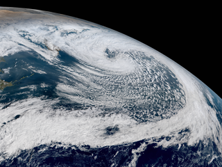
English: The Himawari-8 satellite captured a powerful typhoon-force extratropical cyclone east of the Kamchatka Peninsula late on October 24 (locally before noon on October 25), 2017. In terms of minimal pressure, it was the strongest extratropical cyclone of the Northern Hemisphere in 2017, which central pressure reached 934 hPa earlier. The energy from the remnants of Typhoon Lan triggered explosive cyglogenesis. |
| Ημερομηνία | |
| Πηγή | RAMMB/CIRA SLIDER |
| Δημιουργός | AHI image captured by the Japan Meteorological Agency’s Himawari-8 satellite |
| Camera location | | View this and other nearby images on: OpenStreetMap |
|---|
Αδειοδότηση
This image is in the public domain because it contains materials that originally came from the U.S. National Oceanic and Atmospheric Administration, taken or made as part of an employee's official duties.
|
Ιστορικό αρχείου
Κλικάρετε σε μια ημερομηνία/ώρα για να δείτε το αρχείο όπως εμφανιζόταν εκείνη τη στιγμή.
| Ώρα/Ημερομ. | Μικρογραφία | Διαστάσεις | Χρήστης | Σχόλια | |
|---|---|---|---|---|---|
| τελευταία | 09:30, 23 Ιανουαρίου 2018 | | 3.600 × 2.700 (13,16 MB) | Meow | Slightly adjusted the hue. |
| 06:56, 25 Οκτωβρίου 2017 |  | 3.600 × 2.700 (13,03 MB) | Meow | User created page with UploadWizard |
Συνδέσεις αρχείου
Τα παρακάτω λήμματα συνδέουν σε αυτό το αρχείο:
Καθολική χρήση αρχείου
Τα ακόλουθα άλλα wiki χρησιμοποιούν αυτό το αρχείο:
- Χρήση σε ar.wikipedia.org
- Χρήση σε en.wikipedia.org
- Χρήση σε it.wikipedia.org