Αρχείο:Pinus ponderosa subspecies range map.png
Μέγεθος αυτής της προεπισκόπησης: 489 × 599 εικονοστοιχεία . Άλλες αναλύσεις: 196 × 240 εικονοστοιχεία | 609 × 746 εικονοστοιχεία.
Εικόνα σε υψηλότερη ανάλυση (609 × 746 εικονοστοιχεία, μέγεθος αρχείου: 77 KB, τύπος MIME: image/png)
|
|
Αυτό το αρχείο και η περιγραφή του προέρχονται από το Wikimedia Commons. Οι πληροφορίες από την σελίδα περιγραφής του εκεί εμφανίζονται παρακάτω. |
| Περιγραφή |
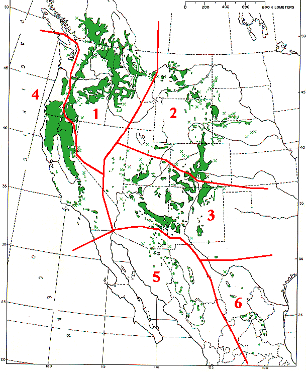
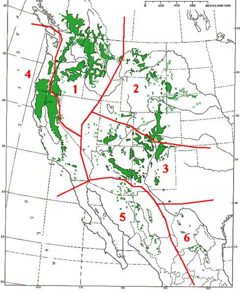
Range map of Pinus ponderosa and Pinus arizonica
|
|||
| Ημερομηνία | ||||
| Πηγή | Base map (black outlines & green range map) is from USDA Forest Service Misc,.Publ. 991 (public domain-USGov); red delineation is my work, which I release into public domain | |||
| Δημιουργός | MPF | |||
| Άδεια (Επαναχρησιμοποίηση αυτού του αρχείου) |
|
Ιστορικό αρχείου
Κλικάρετε σε μια ημερομηνία/ώρα για να δείτε το αρχείο όπως εμφανιζόταν εκείνη τη στιγμή.
| Ώρα/Ημερομ. | Μικρογραφία | Διαστάσεις | Χρήστης | Σχόλια | |
|---|---|---|---|---|---|
| τελευταία | 14:09, 7 Δεκεμβρίου 2009 | | 609 × 746 (77 KB) | MPF | {{Information |Description=Range map of ''Pinus ponderosa'' and ''Pinus arizonica'' # ''Pinus ponderosa'' subsp. ''ponderosa'' - North Plateau Ponderosa Pine # ''Pinus ponderosa'' subsp. ''scopulorum'' - Rocky Mts Ponderosa Pine # ''Pinus ponderos |
Συνδέσεις αρχείου
Τα παρακάτω λήμματα συνδέουν σε αυτό το αρχείο:
Καθολική χρήση αρχείου
Τα ακόλουθα άλλα wiki χρησιμοποιούν αυτό το αρχείο:
- Χρήση σε arz.wikipedia.org
- Χρήση σε ca.wikipedia.org
- Χρήση σε cs.wikipedia.org
- Χρήση σε es.wikipedia.org
- Χρήση σε id.wikipedia.org
- Χρήση σε nl.wikipedia.org
- Χρήση σε pl.wikipedia.org
- Χρήση σε pt.wikipedia.org
- Χρήση σε sv.wikipedia.org
- Χρήση σε tr.wikipedia.org
- Χρήση σε uk.wikipedia.org
- Χρήση σε www.wikidata.org