Αρχείο:Balkans-ethnique.JPG

Εικόνα σε υψηλότερη ανάλυση (1.258 × 1.266 εικονοστοιχεία, μέγεθος αρχείου: 457 KB, τύπος MIME: image/jpeg)
|
|
Αυτό το αρχείο και η περιγραφή του προέρχονται από το Wikimedia Commons. Οι πληροφορίες από την σελίδα περιγραφής του εκεί εμφανίζονται παρακάτω. |

|
This map image could be re-created using vector graphics as an SVG file. This has several advantages; see Commons:Media for cleanup for more information. If an SVG form of this image is available, please upload it and afterwards replace this template with
{{vector version available|new image name}}.
It is recommended to name the SVG file “Balkans-ethnique.svg”—then the template Vector version available (or Vva) does not need the new image name parameter. |


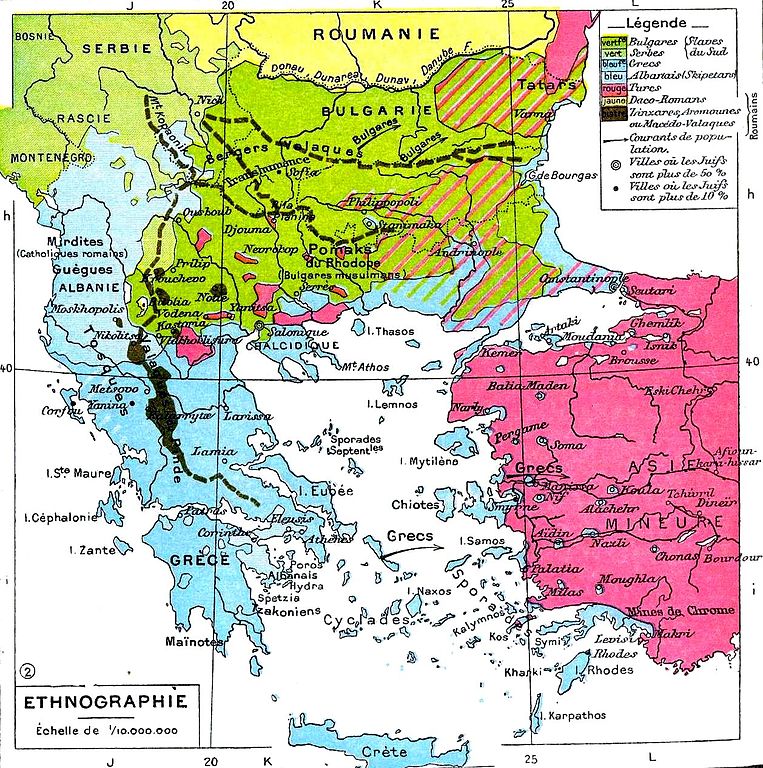
| Περιγραφή | Ethnic map of the Balkans. | ||||
| Ημερομηνία | |||||
| Πηγή | Histoire Et Géographie - Atlas Général Vidal-Lablache, Librairie Armand Colin, Paris, 1898. | ||||
| Δημιουργός | Paul Vidal de la Blache | ||||
| Άδεια (Επαναχρησιμοποίηση αυτού του αρχείου) |
|
||||
| άλλες εκδόσεις |
 |
||||
Ιστορικό αρχείου
Κλικάρετε σε μια ημερομηνία/ώρα για να δείτε το αρχείο όπως εμφανιζόταν εκείνη τη στιγμή.
| Ώρα/Ημερομ. | Μικρογραφία | Διαστάσεις | Χρήστης | Σχόλια | |
|---|---|---|---|---|---|
| τελευταία | 18:47, 7 Νοεμβρίου 2009 | | 1.258 × 1.266 (457 KB) | Alex:D | whitened |
| 07:55, 8 Φεβρουαρίου 2007 |  | 1.258 × 1.266 (346 KB) | Olahus | '''Description:''' Carte ethnique des Balkans '''Source:''' Histoire Et Géographie - Atlas Général Vidal-Lablache, Librairie Armand Colin, Paris, 1898 '''Author:''' Scan made by Olahus '''License:''' Public Domain, because copyright |
Συνδέσεις αρχείου
Τα παρακάτω λήμματα συνδέουν σε αυτό το αρχείο:
Καθολική χρήση αρχείου
Τα ακόλουθα άλλα wiki χρησιμοποιούν αυτό το αρχείο:
- Χρήση σε ar.wikipedia.org
- Χρήση σε azb.wikipedia.org
- Χρήση σε ba.wikipedia.org
- Χρήση σε bg.wikipedia.org
- Χρήση σε cs.wikipedia.org
- Χρήση σε cv.wikipedia.org
- Χρήση σε cy.wikipedia.org
- Χρήση σε da.wikipedia.org
- Χρήση σε de.wikipedia.org
- Χρήση σε en.wikipedia.org
- Χρήση σε es.wikipedia.org
- Χρήση σε eu.wikipedia.org
- Χρήση σε fr.wikipedia.org
- Χρήση σε gl.wikipedia.org
- Χρήση σε he.wikipedia.org
- Χρήση σε it.wikipedia.org
- Χρήση σε ja.wikipedia.org
- Χρήση σε jv.wikipedia.org
- Χρήση σε nn.wikipedia.org
- Χρήση σε no.wikipedia.org
- Χρήση σε pl.wikipedia.org
Δείτε περισσότερη καθολική χρήση αυτού του αρχείου.