Αρχείο:Colombia.A2004117.1535.250m.jpg

Εικόνα σε υψηλότερη ανάλυση (1.500 × 2.000 εικονοστοιχεία, μέγεθος αρχείου: 898 KB, τύπος MIME: image/jpeg)
|
|
Αυτό το αρχείο και η περιγραφή του προέρχονται από το Wikimedia Commons. Οι πληροφορίες από την σελίδα περιγραφής του εκεί εμφανίζονται παρακάτω. |
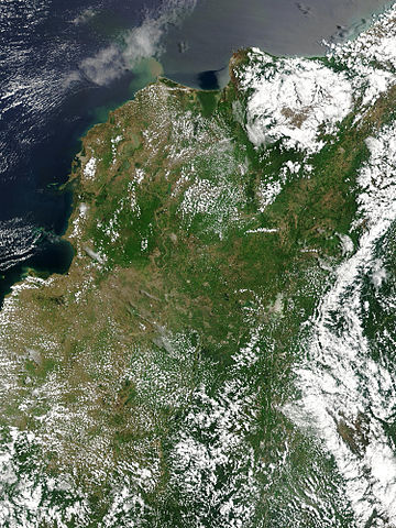
Floods in Colombia, April 2004.
Marshes and wetlands line Colombia’s Magdalena River in its course north from the Andes Mountains to the Caribbean Sea. The wetlands, which form black and blue patches along the river in the false color image, are important for birds arriving from the north for the winter. The area had received heavy rain which triggered floods and landslides. Though the floods aren't visible in these images, the tan plume of sediment flowing into the Caribbean from the Magdalena River in the true-color image may be a result of high, fast-moving waters carrying extra mud into the sea. This true and false color image pair was captured by the Moderate Resolution Imaging Spectroradiometer (MODIS) on the Aqua satellite on April 26, 2004.
http://visibleearth.nasa.gov/view_rec.php?id=6531 archive copy at the Wayback Machine
| Αυτό το αρχείο είναι κοινό κτήμα γιατί δημιουργήθηκε από την NASA. Η πολιτική πνευματικής ιδιοκτησίας της NASA δηλώνει ότι «Το υλικό της NASA δεν προστατεύεται από copyright εκτός αν αναφέρεται». (Σελίδα με την πολιτική πνευματικής ιδιοκτησίας της NASA ή Πολιτική Χρήσης Εικόνων του JPL). | ||
 |
Προσοχή:
|
Ιστορικό αρχείου
Κλικάρετε σε μια ημερομηνία/ώρα για να δείτε το αρχείο όπως εμφανιζόταν εκείνη τη στιγμή.
| Ώρα/Ημερομ. | Μικρογραφία | Διαστάσεις | Χρήστης | Σχόλια | |
|---|---|---|---|---|---|
| τελευταία | 19:36, 27 Οκτωβρίου 2005 | | 1.500 × 2.000 (898 KB) | Brian0918 | Floods in Colombia, April 2004. Marshes and wetlands line Colombia’s Magdalena River in its course north from the Andes Mountains to the Caribbean Sea. The wetlands, which form black and blue patches along the river in the false color image, are import |
Συνδέσεις αρχείου
Τα παρακάτω λήμματα συνδέουν σε αυτό το αρχείο:
Καθολική χρήση αρχείου
Τα ακόλουθα άλλα wiki χρησιμοποιούν αυτό το αρχείο:
- Χρήση σε af.wikipedia.org
- Χρήση σε ar.wikipedia.org
- Χρήση σε en.wikipedia.org
- Χρήση σε fr.wikipedia.org
- Χρήση σε ms.wikipedia.org
- Χρήση σε ru.wikipedia.org
- Χρήση σε sl.wikipedia.org
- Χρήση σε uk.wikipedia.org
- Χρήση σε vi.wikipedia.org