Αρχείο:Colonisation 1754.png

Εικόνα σε υψηλότερη ανάλυση (1.799 × 789 εικονοστοιχεία, μέγεθος αρχείου: 144 KB, τύπος MIME: image/png)
|
|
Αυτό το αρχείο και η περιγραφή του προέρχονται από το Wikimedia Commons. Οι πληροφορίες από την σελίδα περιγραφής του εκεί εμφανίζονται παρακάτω. |
| Περιγραφή |
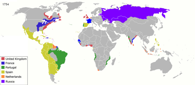
Map of major world powers by year, derived from public domain animated map on wikipedia.
As the orriginal licence of the animation was Public Domain, this image which has been derived from it is too:
|
||||||||||||||||||
| Ημερομηνία | |||||||||||||||||||
| Πηγή | public domain animated map by ArdadN here | ||||||||||||||||||
| Δημιουργός | ArdadN | ||||||||||||||||||
| άλλες εκδόσεις |
|
||||||||||||||||||

.jpg)
._LOC_2001620596.jpg)
Ιστορικό αρχείου
Κλικάρετε σε μια ημερομηνία/ώρα για να δείτε το αρχείο όπως εμφανιζόταν εκείνη τη στιγμή.
| Ώρα/Ημερομ. | Μικρογραφία | Διαστάσεις | Χρήστης | Σχόλια | |
|---|---|---|---|---|---|
| τελευταία | 23:55, 17 Μαρτίου 2022 | | 1.799 × 789 (144 KB) | M.Bitton | per https://commons.wikimedia.org/w/index.php?title=Commons:Graphic_Lab/Map_workshop&oldid=640501111#Wrong_borders |
| 12:27, 4 Οκτωβρίου 2020 |  | 1.799 × 789 (460 KB) | Ориенталист | quality | |
| 09:30, 5 Απριλίου 2020 |  | 1.200 × 526 (263 KB) | Ориенталист | cosmetic changes | |
| 14:47, 27 Μαρτίου 2020 |  | 1.799 × 789 (532 KB) | Ориенталист | Clarified the territory of Russia. By 1754, the north of Siberia had already been explored | |
| 20:44, 2 Νοεμβρίου 2017 |  | 1.425 × 625 (71 KB) | Alvin Lee | According to the Treaty of Nerchinsk in 1689, Outer Manchuria was the territory of China (Qing Dynasty), not Russia. Russia got Outer Manchuria after Treaty of Aigun of 1858. | |
| 20:30, 2 Νοεμβρίου 2017 |  | 1.425 × 625 (47 KB) | Alvin Lee | I am changing the ancient boarder of Qing dynasty and Russia, not the modern boarder | |
| 15:35, 14 Φεβρουαρίου 2017 |  | 1.425 × 625 (43 KB) | Fentener van Vlissingen | Reverted to version as of 23:29, 27 June 2012 (UTC) that edit did not change the borders between Russia and China and re-added errors fixed in previous version | |
| 00:35, 3 Αυγούστου 2014 |  | 1.425 × 625 (47 KB) | Alvin Lee | Correcting the boundaries of Russia and China | |
| 23:29, 27 Ιουνίου 2012 |  | 1.425 × 625 (43 KB) | Fentener van Vlissingen | There are still many things wrong with this map, but I corrected the most blatant errors: right shade of Orange for Demerara, Essequibo, Berbice, added Dutch Gold Coast, Dutch Malabar, Dutch Coromandel, Dutch Bengal. European presence in Africa and Ind... | |
| 21:27, 23 Ιανουαρίου 2011 |  | 1.425 × 625 (66 KB) | Micsha~commonswiki | Reverted to version as of 13:52, 29 April 2010 |
Συνδέσεις αρχείου
Τα παρακάτω λήμματα συνδέουν σε αυτό το αρχείο:
Καθολική χρήση αρχείου
Τα ακόλουθα άλλα wiki χρησιμοποιούν αυτό το αρχείο:
- Χρήση σε als.wikipedia.org
- Χρήση σε ar.wikipedia.org
- Χρήση σε ast.wikipedia.org
- Χρήση σε azb.wikipedia.org
- Χρήση σε bn.wikipedia.org
- Χρήση σε br.wikipedia.org
- Χρήση σε de.wikipedia.org
- Χρήση σε en.wikipedia.org
- Χρήση σε es.wikipedia.org
- Χρήση σε et.wikipedia.org
- Χρήση σε fr.wikipedia.org
- Χρήση σε ko.wikipedia.org
- Χρήση σε la.wikipedia.org
- Χρήση σε no.wikipedia.org
- Χρήση σε oc.wikipedia.org
- Χρήση σε pt.wikipedia.org
- Χρήση σε ro.wikipedia.org
- Χρήση σε sh.wikipedia.org
- Χρήση σε sw.wikipedia.org
- Χρήση σε te.wikipedia.org
- Χρήση σε uk.wikipedia.org