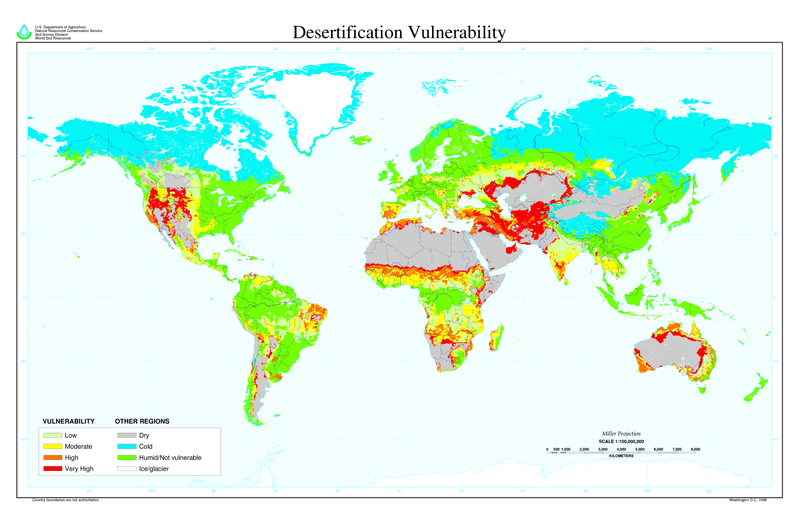
Αρχείο:Desertification map.png

Μέγεθος αυτής της προεπισκόπησης: 800 × 518 εικονοστοιχεία . Άλλες αναλύσεις: 320 × 207 εικονοστοιχεία | 640 × 414 εικονοστοιχεία | 1.024 × 663 εικονοστοιχεία | 1.280 × 828 εικονοστοιχεία | 2.560 × 1.656 εικονοστοιχεία | 6.800 × 4.400 εικονοστοιχεία.
Εικόνα σε υψηλότερη ανάλυση (6.800 × 4.400 εικονοστοιχεία, μέγεθος αρχείου: 1,04 MB, τύπος MIME: image/png)
Ιστορικό αρχείου
Κλικάρετε σε μια ημερομηνία/ώρα για να δείτε το αρχείο όπως εμφανιζόταν εκείνη τη στιγμή.
| Ώρα/Ημερομ. | Μικρογραφία | Διαστάσεις | Χρήστης | Σχόλια | |
|---|---|---|---|---|---|
| τελευταία | 11:01, 27 Μαρτίου 2022 |  | 6.800 × 4.400 (1,04 MB) | No.cilepogača | Reverted to version as of 00:12, 8 November 2006 (UTC) |
| 05:11, 8 Νοεμβρίου 2006 |  | 1.700 × 1.100 (558 KB) | Paleorthid | {{Information |Description=Global Desertification Vulnerability Map |Source=http://soils.usda.gov/use/worldsoils/mapindex/desert-map.zip |Date=1998 |Author=USDA employee |Permission=This image is a work of a United States Department of Agriculture employe | |
| 00:12, 8 Νοεμβρίου 2006 |  | 6.800 × 4.400 (1,04 MB) | Paleorthid | {{Information |Description=Global Desertification Vulnerability Map |Source=http://soils.usda.gov/use/worldsoils/mapindex/desert-map.zip |Date=1998 |Author=USDA employee |Permission=This image is a work of a United States Department of Agriculture employe |
Συνδέσεις αρχείου
Τα παρακάτω λήμματα συνδέουν σε αυτό το αρχείο:
Καθολική χρήση αρχείου
Τα ακόλουθα άλλα wiki χρησιμοποιούν αυτό το αρχείο:
- Χρήση σε ar.wikipedia.org
- Χρήση σε az.wikipedia.org
- Χρήση σε bg.wikipedia.org
- Χρήση σε bn.wikipedia.org
- Χρήση σε bo.wikipedia.org
- Χρήση σε ca.wikinews.org
- Χρήση σε ckb.wikipedia.org
- Χρήση σε cs.wikipedia.org
- Χρήση σε da.wikipedia.org
- Χρήση σε de.wikipedia.org
- Χρήση σε de.wiktionary.org
- Χρήση σε en.wikipedia.org
- Χρήση σε eo.wikipedia.org
- Χρήση σε es.wikipedia.org
- Χρήση σε eu.wikipedia.org
- Χρήση σε fa.wikipedia.org
- Χρήση σε fi.wikipedia.org
- Χρήση σε fr.wikipedia.org
- Χρήση σε fr.wikinews.org
- Χρήση σε ga.wikipedia.org
- Χρήση σε he.wikipedia.org
- Χρήση σε hu.wikipedia.org
- Χρήση σε hy.wikipedia.org
- Χρήση σε id.wikipedia.org
- Χρήση σε is.wikipedia.org
- Χρήση σε it.wikipedia.org
- Χρήση σε ja.wikipedia.org
- Χρήση σε ko.wikipedia.org
Δείτε περισσότερη καθολική χρήση αυτού του αρχείου.
