Αρχείο:ElectoralCollege1988-Large.png
Μέγεθος αυτής της προεπισκόπησης: 800 × 430 εικονοστοιχεία . Άλλες αναλύσεις: 320 × 172 εικονοστοιχεία | 640 × 344 εικονοστοιχεία | 1.182 × 635 εικονοστοιχεία.
Εικόνα σε υψηλότερη ανάλυση (1.182 × 635 εικονοστοιχεία, μέγεθος αρχείου: 170 KB, τύπος MIME: image/png)
|
|
Αυτό το αρχείο και η περιγραφή του προέρχονται από το Wikimedia Commons. Οι πληροφορίες από την σελίδα περιγραφής του εκεί εμφανίζονται παρακάτω. |
| U.S. presidential election maps from the National Atlas of the United States |
| See also: SVG maps |
| 1789 · 1792 · 1796 · 1800 · 1804 · 1808 · 1812 · 1816 · 1820 · 1824 · 1828 · 1832 · 1836 · 1840 · 1844 · 1848 · 1852 · 1856 · 1860 · 1864 · 1868 · 1872 · 1876 · 1880 · 1884 · 1888 · 1892 · 1896 · 1900 · 1904 · 1908 · 1912 · 1916 · 1920 · 1924 · 1928 · 1932 · 1936 · 1940 · 1944 · 1948 · 1952 · 1956 · 1960 · 1964 · 1968 · 1972 · 1976 · 1980 · 1984 · 1988 · 1992 · 1996 · 2000 · 2004 |
Σύνοψη
| Περιγραφή |
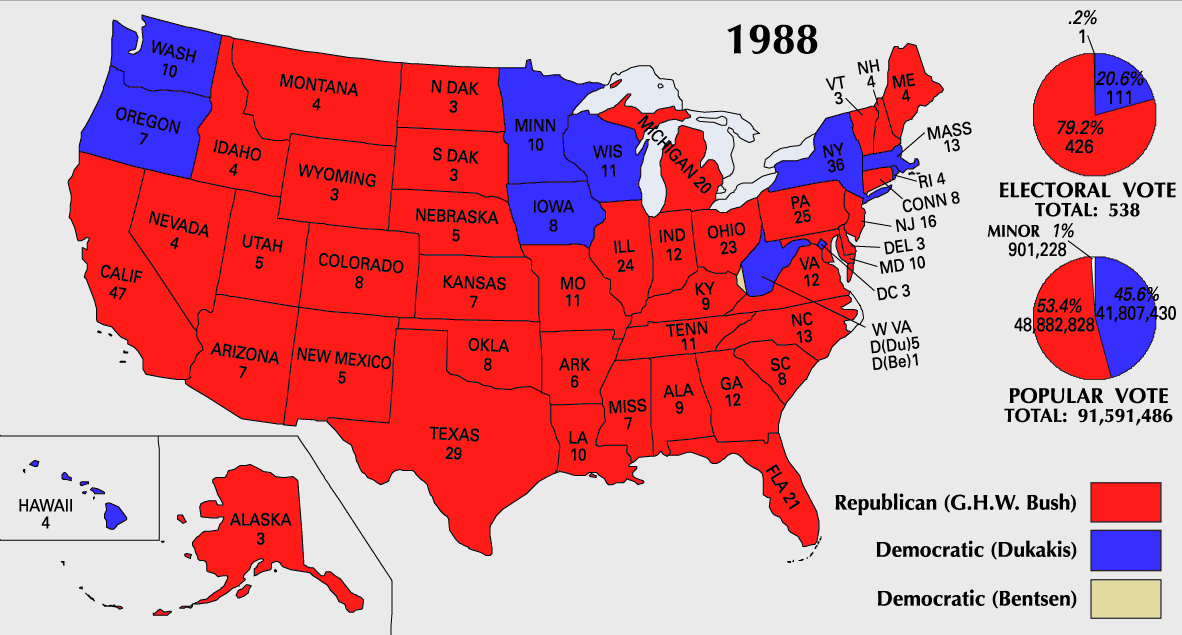
English: 1988 Electoral College Map |
||
| Πηγή | https://nationalmap.gov/small_scale/printable/elections.html | ||
| Δημιουργός | Γεωλογικό Ινστιτούτο Ηνωμένων Πολιτειών | ||
| άλλες εκδόσεις |
|

Αδειοδότηση
This map was obtained from an edition of the National Atlas of the United States. Like almost all works of the U.S. federal government, works from the National Atlas are in the public domain in the United States.
Online access: NationalAtlas.gov | 1970 print edition: Library of Congress, Perry-Castañeda Library
|
Ιστορικό αρχείου
Κλικάρετε σε μια ημερομηνία/ώρα για να δείτε το αρχείο όπως εμφανιζόταν εκείνη τη στιγμή.
| Ώρα/Ημερομ. | Μικρογραφία | Διαστάσεις | Χρήστης | Σχόλια | |
|---|---|---|---|---|---|
| τελευταία | 10:21, 25 Ιουλίου 2007 | | 1.182 × 635 (170 KB) | Cardsplayer4life~commonswiki | Reverted to earlier revision |
| 09:31, 25 Ιουλίου 2007 |  | 1.182 × 635 (110 KB) | Joseph Solis in Australia~commonswiki | {{PD-USGov-Atlas}} Category:1988 {{US presidential election maps}} | |
| 01:47, 9 Ιουλίου 2007 |  | 1.182 × 635 (170 KB) | Cardsplayer4life~commonswiki | {{PD-USGov-Atlas}} {{US presidential election maps}} | |
| 09:34, 6 Ιουλίου 2007 |  | 1.182 × 635 (110 KB) | Joseph Solis in Australia~commonswiki | {{PD-USGov-Atlas}} Category:1988 {{US presidential election maps}} | |
| 02:29, 2 Ιουλίου 2007 |  | 1.182 × 635 (170 KB) | Cardsplayer4life~commonswiki | {{PD-USGov-Atlas}} {{US presidential election maps}} | |
| 10:13, 29 Ιουνίου 2007 |  | 1.182 × 635 (110 KB) | Joseph Solis in Australia~commonswiki | {{PD-USGov-Atlas}} Category:1988 {{US presidential election maps}} | |
| 21:06, 21 Ιουνίου 2007 |  | 1.182 × 635 (170 KB) | Cardsplayer4life~commonswiki | {{PD-USGov-Atlas}} Category:1988 {{US presidential election maps}} | |
| 16:05, 22 Ιανουαρίου 2006 |  | 1.182 × 635 (110 KB) | Red devil 666 | {{PD-USGov-Atlas}} |
Συνδέσεις αρχείου
Δεν υπάρχουν σελίδες που συνδέουν σε αυτό το αρχείο.
Καθολική χρήση αρχείου
Τα ακόλουθα άλλα wiki χρησιμοποιούν αυτό το αρχείο:
- Χρήση σε da.wikipedia.org
- Χρήση σε en.wikipedia.org
- Χρήση σε nl.wikipedia.org
- Χρήση σε no.wikipedia.org
- Χρήση σε sv.wikipedia.org
- Χρήση σε uk.wikipedia.org