Αρχείο:France departments 1791 (1).jpg

Εικόνα σε υψηλότερη ανάλυση (1.635 × 1.303 εικονοστοιχεία, μέγεθος αρχείου: 895 KB, τύπος MIME: image/jpeg)
|
|
Αυτό το αρχείο και η περιγραφή του προέρχονται από το Wikimedia Commons. Οι πληροφορίες από την σελίδα περιγραφής του εκεί εμφανίζονται παρακάτω. |
.jpg?uselang=el)
| Περιγραφή |
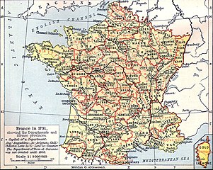
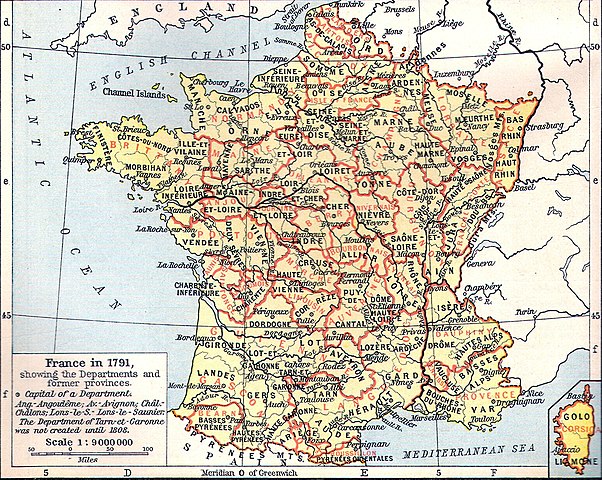
Français : Carte de la France en 1791 (départements et anciennes provinces - en rouge) in The Historical Atlas by William R. Shepherd, 1926
Lëtzebuergesch: Departementer vu Frankräich am Joer 1791. |
| Ημερομηνία | 11 Μαρτίου 2006 (original upload date) |
| Πηγή | Transferred from fr.wikipedia to Commons by Korrigan using CommonsHelper. |
| Δημιουργός | The original uploader was Tournachon at Γαλλικά Βικιπαίδεια. |
| άλλες εκδόσεις | Derivative works of this file: Départements et provinces de France.png |
Αδειοδότηση
|
Αυτό το έργο είναι κοινό κτήμα στη χώρα προέλευσής του και άλλες χώρες και περιοχές όπου η διάρκεια πνευματικών δικαιωμάτων είναι όσο η ζωή του δημιουργού και μέχρι 70 χρόνια μετά ή λιγότερο.
| |
| Αυτό το αρχείο έχει χαρακτηριστεί ως απαλλαγμένο από γνωστούς περιορισμούς βάσει της νομοθεσίας περί πνευματικής ιδιοκτησίας, περιλαμβανομένων όλων των συναφών και συγγενικών δικαιωμάτων. | |
Καταγραφές ανεβασμάτων πρωτότυπου αρχείου
- 2006-03-11 14:51 Tournachon 741×599×??? (225908 bytes)
Ιστορικό αρχείου
Κλικάρετε σε μια ημερομηνία/ώρα για να δείτε το αρχείο όπως εμφανιζόταν εκείνη τη στιγμή.
| Ώρα/Ημερομ. | Μικρογραφία | Διαστάσεις | Χρήστης | Σχόλια | |
|---|---|---|---|---|---|
| τελευταία | 14:31, 22 Ιουλίου 2022 | | 1.635 × 1.303 (895 KB) | Hohum | Clearer version |
| 22:43, 24 Ιανουαρίου 2012 |  | 741 × 599 (634 KB) | MarcusBritish | Lower red tint. | |
| 22:41, 24 Ιανουαρίου 2012 |  | 741 × 599 (622 KB) | MarcusBritish | Improve tones/colour/contrast. | |
| 08:46, 22 Σεπτεμβρίου 2008 |  | 741 × 599 (221 KB) | File Upload Bot (Magnus Manske) | {{BotMoveToCommons|fr.wikipedia}} {{Information |Description={{fr|Carte de la France en 1791 (départements et anciennes provinces - en rouge) in The Historical Atlas by William R. Shepherd, 1926 == Licence == [[:fr:Catégorie:Cartes Histoire de Fr |
Συνδέσεις αρχείου
Τα παρακάτω λήμματα συνδέουν σε αυτό το αρχείο:
Καθολική χρήση αρχείου
Τα ακόλουθα άλλα wiki χρησιμοποιούν αυτό το αρχείο:
- Χρήση σε als.wikipedia.org
- Χρήση σε br.wikipedia.org
- Χρήση σε de.wikipedia.org
- Χρήση σε eo.wikipedia.org
- Χρήση σε es.wikipedia.org
- Χρήση σε eu.wikipedia.org
- Χρήση σε fi.wikipedia.org
- Χρήση σε fr.wikipedia.org
- Χρήση σε hu.wikipedia.org
- Χρήση σε lb.wikipedia.org
- Χρήση σε lv.wikipedia.org
- Χρήση σε mt.wikipedia.org
- Χρήση σε nn.wikipedia.org
- Χρήση σε oc.wikipedia.org
- Χρήση σε pl.wikipedia.org
.jpg)