Αρχείο:Greece GHI Solar-resource-map GlobalSolarAtlas World-Bank-Esmap-Solargis.png

Εικόνα σε υψηλότερη ανάλυση (1.842 × 2.063 εικονοστοιχεία, μέγεθος αρχείου: 1,48 MB, τύπος MIME: image/png)
|
|
Αυτό το αρχείο και η περιγραφή του προέρχονται από το Wikimedia Commons. Οι πληροφορίες από την σελίδα περιγραφής του εκεί εμφανίζονται παρακάτω. |
Σύνοψη
| Περιγραφή |
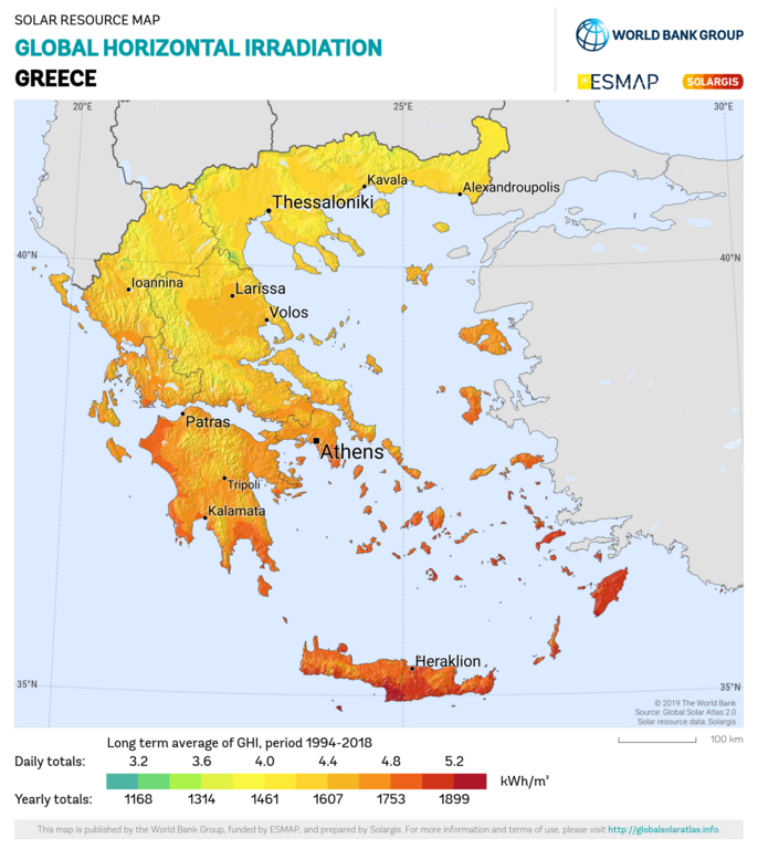
English: Solar resource: GLOBAL HORIZONTAL IRRADIATION (GHI) - this map provides a summary of the estimated solar energy available for power generation and other energy applications. It represents the long-term average of daily/yearly totals of global horizontal irradiation (GHI). The underlying solar resource database is calculated by the Solargis model from atmospheric and satellite data with 15- or 30-minute time step. The effects of terrain are considered at nominal spatial resolution of 250 m. GHI is the most important parameter for energy yield calculation and performance assessment of flat-plate photovoltaic (PV) technologies. Further details available at: https://globalsolaratlas.info. |
| Ημερομηνία | |
| Πηγή | https://globalsolaratlas.info/downloads |
| Δημιουργός | Solargis |
| Απόδοση (required by the license) | © The World Bank, Source: Global Solar Atlas 2.0, Solar resource data: Solargis / |
The World Bank Group has published this solar resource map using data from the Global Solar Atlas (GSA), to support the scale-up of solar power in our client countries. This work is funded by the Energy Sector Management Assistance Program (ESMAP), a multi-donor trust fund administered by The World Bank and supported by 18 donor partners. It is part of a global ESMAP initiative on Renewable Energy Resource Mapping that covers biomass, hydropower, solar and wind. This map has been prepared by Solargis, under contract to The World Bank, based on a solar resource database that Solargis owns and maintains. To obtain additional maps and information, please visit: http://globalsolaratlas.info.
Αδειοδότηση
- Είστε ελεύθερος:
- να μοιραστείτε – να αντιγράψετε, διανέμετε και να μεταδώσετε το έργο
- να διασκευάσετε – να τροποποιήσετε το έργο
- Υπό τις ακόλουθες προϋποθέσεις:
- αναφορά προέλευσης – Θα πρέπει να κάνετε κατάλληλη αναφορά, να παρέχετε σύνδεσμο για την άδεια και να επισημάνετε εάν έγιναν αλλαγές. Μπορείτε να το κάνετε με οποιοδήποτε αιτιολογήσιμο λόγο, χωρίς όμως να εννοείται με οποιονδήποτε τρόπο ότι εγκρίνουν εσάς ή τη χρήση του έργου από εσάς.
Ιστορικό αρχείου
Κλικάρετε σε μια ημερομηνία/ώρα για να δείτε το αρχείο όπως εμφανιζόταν εκείνη τη στιγμή.
| Ώρα/Ημερομ. | Μικρογραφία | Διαστάσεις | Χρήστης | Σχόλια | |
|---|---|---|---|---|---|
| τελευταία | 14:08, 27 Ιανουαρίου 2021 | | 1.842 × 2.063 (1,48 MB) | SolarSoft | Updated temporal coverage, recalculated data period. |
| 13:55, 31 Μαΐου 2011 |  | 800 × 869 (474 KB) | SolarSoft |
Συνδέσεις αρχείου
Τα παρακάτω λήμματα συνδέουν σε αυτό το αρχείο:
Καθολική χρήση αρχείου
Τα ακόλουθα άλλα wiki χρησιμοποιούν αυτό το αρχείο:
- Χρήση σε ar.wikipedia.org
- Χρήση σε az.wikipedia.org
- Χρήση σε en.wikipedia.org
- Χρήση σε es.wikipedia.org
- Χρήση σε fi.wikipedia.org
- Χρήση σε fr.wikipedia.org
- Χρήση σε it.wikipedia.org
- Χρήση σε ka.wikipedia.org
- Χρήση σε ru.wikipedia.org
- Χρήση σε sl.wikipedia.org
- Χρήση σε sr.wikipedia.org
- Χρήση σε test2.wikipedia.org
- Χρήση σε te.wikipedia.org