Αρχείο:Hooker Map of the State of Coahuila and Texas 1833 UTA.jpg
Εικόνα σε υψηλότερη ανάλυση (3.516 × 2.793 εικονοστοιχεία, μέγεθος αρχείου: 9,26 MB, τύπος MIME: image/jpeg)
|
|
Αυτό το αρχείο και η περιγραφή του προέρχονται από το Wikimedia Commons. Οι πληροφορίες από την σελίδα περιγραφής του εκεί εμφανίζονται παρακάτω. |
Σύνοψη
| Τίτλος |
English: Map of the State of Coahuila and Texas |
||||||||||||||||||||||||||
| Περιγραφή |
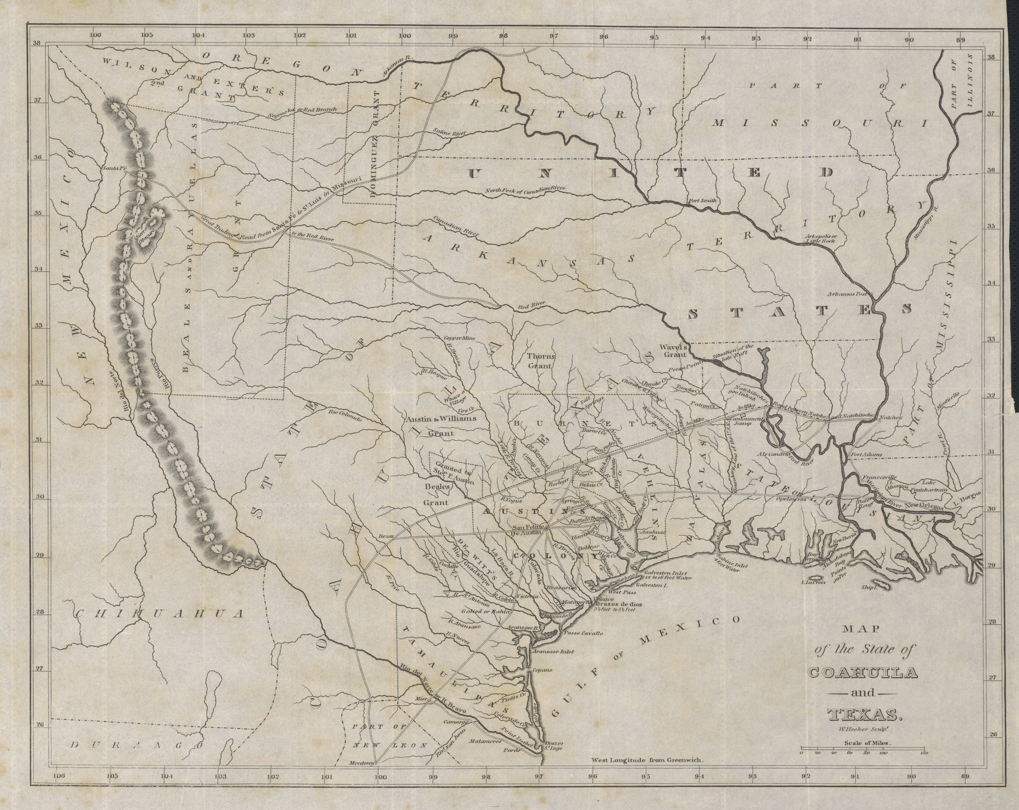
English: Philadelphia engraver, printer, map publisher, and instrument maker William Hooker's Map of Coahuila and Texas first appeared in an 1833 promotional book on Texas by Mary Austin Holley (1784-1846), a first cousin of the famous Texas colonizer Stephen F. Austin. Holley and her publisher, Armstrong & Plaskitt of Baltimore substituted Hooker's map when Henry S. Tanner, the publisher of Stephen F. Austin's large map of Texas, refused to allow the latter to be used in the book. Hooker's map shows the Austin Colony capital town of San Felipe de Austin at the center of roads leading to a number of settlements including Bexar (San Antonio de Bexar), Victoria and Goliad or Bahia, Matagorda, Brazaria (sic, Brazoria), Harrisburg and Buffalo Bayou as well as a road connecting to the older Camino Real or old Spanish road between Bexar and Nacogdoches. Lands granted to individuals under the Mexican empresario system are shown. In addition to Stephen F. Austin's grants awarded in 1821 (confirmed in 1823 and extended by further contracts in 1825, 1827, and 1828), these include the grants of Green DeWitt (contract awarded in 1825), Frost Thorn (1825), Benjamin R. Milam (1826), David G. Burnet (1826), Arthur G. Wavell (1826), Joseph Vehlein (1826 and 1828), Lorenzo de Zavala (1829), Juan Dominguez y Valdez (1829), Richard Exter (1826, 1828), John Charles Beale (1830). The lands in west Texas granted to Beale and José Manuel Royuela and to Austin and his partner Samuel May Williams in 1832 are the latest to appear on the map. References to other land grants are missing but some would appear on later editions in 1834 and 1836. |
||||||||||||||||||||||||||
| Ημερομηνία | |||||||||||||||||||||||||||
| Πηγή | UTA Libraries Cartographic Connections: χάρτης / text | ||||||||||||||||||||||||||
| Δημιουργός |
|
||||||||||||||||||||||||||
| Πιστωτική γραμμή |
English: The University of Texas at Arlington Libraries Special Collections, Gift of Jenkins Garrett |
||||||||||||||||||||||||||
| Geotemporal data | |||||||||||||||||||||||||||
| Map location |
Μεξικό Τέξας |
||||||||||||||||||||||||||
| Georeferencing | If inappropriate please set warp_status = skip to hide. | ||||||||||||||||||||||||||
| Bibliographic data | |||||||||||||||||||||||||||
| Δημοσίευση |
Texas. Observations, Historical, Geographical and Descriptive, in a Series of Letters Written during a Visit to Austin's Colony, with a view to a permanent settlement in that country, in the Autumn of 1831 |
||||||||||||||||||||||||||
| Δημιουργός |
|
||||||||||||||||||||||||||
| Τόπος της δημοσιεύσης | Βαλτιμόρη | ||||||||||||||||||||||||||
| Εκδότης |
Armstrong & Plaskitt |
||||||||||||||||||||||||||
| Archival data | |||||||||||||||||||||||||||
| Συλλογή |
|
||||||||||||||||||||||||||
| Διαστάσεις | ύψος: 27 cm• πλάτος: 34 cm | ||||||||||||||||||||||||||
| Τεχνική | χαρακτικό σε χαρτί | ||||||||||||||||||||||||||
| artwork-references |
Huseman, Ben W. (2014) The Price of Manifest Destiny: Maps Relating to the Southwest Borderlands, 1800-1866, Άρλινγκτον: The University of Texas at Arlington Libraries, p. 16 Streeter, Thomas W. (1983) Bibliography of Texas 1795-1845 (2ος ed.), Woodbridge: Research Publications, Inc., pp. 376–377, 383, 397 «Revised and Enlarged by Archibald Hanna with a Guide to the Microfilm Collection. First published by Oxford University Press, 1955.» Davis, Marty, et al (2007) Going to Texas: Five Centuries of Texas Maps, Φορτ Γουόρθ: Texas Christian University Press, αρ. 17 , p. 35 Day, James M. (1964) Maps of Texas 1527-1900, Όστιν: The Pemberton Press, pp. 18, 22 |
||||||||||||||||||||||||||
Αδειοδότηση

|
This file was provided to Wikimedia Commons by the University of Texas at Arlington Libraries as part of a cooperation project. The University of Texas at Arlington Libraries is part of the University of Texas at Arlington, a public research university located in Arlington, Texas.
|
|
Ο δημιουργός πέθανε το 1846, οπότε αυτό το έργο είναι κοινό κτήμα στη χώρα προέλευσής του και άλλες χώρες και περιοχές όπου η διάρκεια πνευματικών δικαιωμάτων είναι όσο η ζωή του δημιουργού και μέχρι 100 χρόνια μετά ή λιγότερο. Αυτό το έργο είναι κοινό κτήμα στις Ηνωμένες Πολιτείες επειδή δημοσιεύτηκε (ή καταχωρήθηκε στο U.S. Copyright Office) πριν την 1 Ιανουαρίου 1929. | |
| Αυτό το αρχείο έχει χαρακτηριστεί ως απαλλαγμένο από γνωστούς περιορισμούς βάσει της νομοθεσίας περί πνευματικής ιδιοκτησίας, περιλαμβανομένων όλων των συναφών και συγγενικών δικαιωμάτων. | |
Ιστορικό αρχείου
Κλικάρετε σε μια ημερομηνία/ώρα για να δείτε το αρχείο όπως εμφανιζόταν εκείνη τη στιγμή.
| Ώρα/Ημερομ. | Μικρογραφία | Διαστάσεις | Χρήστης | Σχόλια | |
|---|---|---|---|---|---|
| τελευταία | 19:37, 23 Ιουλίου 2019 | | 3.516 × 2.793 (9,26 MB) | Michael Barera | == {{int:filedesc}} == {{Map |title = ''Map of the State of Coahuila and Texas'' |description = {{en|Philadelphia engraver, printer, map publisher, and instrument maker William Hooker's Map of Coahuila and Texas first appeared in an 1833 promotional book on Texas by Mary Austin Holley (1784-1846), a first cousin of the famous Texas colonizer Stephen F. Austin. Holley and her publisher, Armstrong & Plaskitt of Baltimore substituted Hooker's map when Henry S. Tanner, the pub... |
Συνδέσεις αρχείου
Τα παρακάτω λήμματα συνδέουν σε αυτό το αρχείο:
Καθολική χρήση αρχείου
Τα ακόλουθα άλλα wiki χρησιμοποιούν αυτό το αρχείο:
- Χρήση σε ca.wikipedia.org
- Χρήση σε cs.wikipedia.org
- Χρήση σε en.wikipedia.org
- Χρήση σε es.wikipedia.org
- Χρήση σε ja.wikipedia.org
- Χρήση σε ro.wikipedia.org
- Χρήση σε sv.wikipedia.org