Αρχείο:India population density map en.svg

Εικόνα σε υψηλότερη ανάλυση (Αρχείο SVG, ονομαστικό μέγεθος 1.639 × 1.852 εικονοστοιχεία, μέγεθος αρχείου: 1,23 MB)
|
|
Αυτό το αρχείο και η περιγραφή του προέρχονται από το Wikimedia Commons. Οι πληροφορίες από την σελίδα περιγραφής του εκεί εμφανίζονται παρακάτω. |
| Τίτλος |
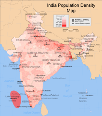
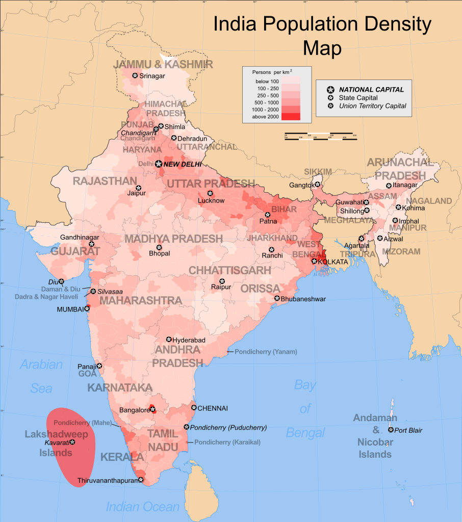
India population density map (english) |
|||||||||
| Περιγραφή |
Map showing the population density of each district in India. Based on 2001 census. |
|||||||||
| Map legend |
 |
|||||||||
| Ημερομηνία | ||||||||||
| Πηγή |
Έργο αυτού που το ανεβάζει |
|||||||||
| Δημιουργός |
|
|||||||||
| Άδεια (Επαναχρησιμοποίηση αυτού του αρχείου) |
Εγώ, ο κάτοχος των πνευματικών δικαιωμάτων αυτού του έργου, το δημοσιεύω δια του παρόντος υπό την εξής άδεια χρήσης: Το αρχείο διανέμεται υπό την άδεια Creative Commons Αναφορά προέλευσης-Παρόμοια διανομή 3.0 Μη εισαγόμενη
|
|||||||||
| Geotemporal data | ||||||||||
| Ημερομηνία που απεικονίζεται | δεύτερο μισό του 20ος αιώνας και 21ος αιώνας | |||||||||
| Spatial reference system | conic | |||||||||
| Bounding box |
|
|||||||||
| Georeferencing | If inappropriate please set warp_status = skip to hide. | |||||||||
| Archival data | ||||||||||
| Σημειώσεις | Part of WikiProject India Maps | |||||||||

Notes
Depiction of India's borders
- The territorial boundaries of India are shown as per the actual ground situation in accordance with international practices followed by the United Nations ([1], [2]) and the National Geographic Society ([3], [4])
- This map is meant to be for illustrative purpose only and is not authenticated by official government sources. Please check the list of sources and references used to create the map for a measure of accuracy and verifiability.
- The usage of these maps in India, Pakistan and China are governed by different laws that restrict depictions of boundaries other than what is officially recognized by the state. Please check local laws and modify the map accordingly before use.
Explanation of disputed boundaries


- Boundary of Indian claim : The territory India claims is legally theirs, but the claim is disputed by China and Pakistan.
- Line of Control/Line of Conflict : The de facto administrative boundary recognised by the international community. This UN ceasefire line is considered as a temporary solution to an ongoing conflict since the departure of the British Raj.
Borders of disputed regions
The depicted extent of the former territory of the British Indian Empire, succeeded by Republic of India, may not be accepted by few countries as legal due to ongoing border disputes:
- The northern Himalayan region of the disputed territory Indian-administered Kashmir is claimed by India including (Pakistan-administered Kashmir) and the Chinese-occupied territory of (Ladakh plateau). Since 1972, it is divided between all three countries. See also Line of Control and Line of Actual Control.
- Siachen glacier (shown white) is an actively contested region between India and Pakistan. Since 1984, the region is under Indian control.
- The northeastern territory of Arunachal Pradesh is almost entirely claimed by China as part of its Tibetan territory.
- Minor areas of eastern Kashmir's Ladakh division, Himachal Pradesh and Uttarakhand on the Chinese frontier are claimed by China. These areas are under Indian control.
- A small area of Uttarakhand adjoining the Nepal border along the Sarda river is disputed between the two countries.
For a detailed map of all disputed regions in South Asia, see Image:India disputed areas map.svg
Internal borders
The borders of the state of Meghalaya, Assam and Arunachal Pradesh are shown as interpreted from the North-Eastern Areas (Reorganisation) Act, 1971, but has yet to be verified.
Territorial waters
The limit of the territorial waters of India extends to twelve nautical miles measured from the appropriate baseline. See this for more information.
derivative works
Derivative works of this file:
Ιστορικό αρχείου
Κλικάρετε σε μια ημερομηνία/ώρα για να δείτε το αρχείο όπως εμφανιζόταν εκείνη τη στιγμή.
| Ώρα/Ημερομ. | Μικρογραφία | Διαστάσεις | Χρήστης | Σχόλια | |
|---|---|---|---|---|---|
| τελευταία | 03:12, 24 Αυγούστου 2009 | | 1.639 × 1.852 (1,23 MB) | Quibik | Made SVG valid. Converted text to paths for correct display. |
| 03:33, 27 Νοεμβρίου 2008 |  | 1.639 × 1.852 (873 KB) | Indianhilbilly | Reverted to version as of 10:10, 18 October 2006, readded original map so that the thumbnail is informative | |
| 16:00, 25 Νοεμβρίου 2008 |  | 1.639 × 1.852 (1,16 MB) | Planemad | added cities and corrected errors | |
| 10:10, 18 Οκτωβρίου 2006 |  | 1.639 × 1.852 (873 KB) | Planemad | {{WikiProject_India_Maps |Title=India population density map (english) |Description=Map showing the population density of each district in India. Based on 2001 census. |Source=India Map site[http://www.censusindiamaps.net Census] - [http://www.censusindia |
Συνδέσεις αρχείου
Τα παρακάτω λήμματα συνδέουν σε αυτό το αρχείο:
Καθολική χρήση αρχείου
Τα ακόλουθα άλλα wiki χρησιμοποιούν αυτό το αρχείο:
- Χρήση σε ar.wikipedia.org
- Χρήση σε be.wikipedia.org
- Χρήση σε bg.wikipedia.org
- Χρήση σε bn.wikipedia.org
- Χρήση σε ca.wikipedia.org
- Χρήση σε ce.wikipedia.org
- Χρήση σε cs.wikipedia.org
- Χρήση σε dv.wikipedia.org
- Χρήση σε dz.wikipedia.org
- Χρήση σε en.wikipedia.org
- List of states and union territories of India by population
- Talk:India/Archive 4
- Portal:India/Selected picture candidates/Archived nominations
- Talk:India/Archive 11
- Portal:India/Selected picture candidates/India population density map
- Talk:India/Demographics
- List of states in India by past population
- Registrar General and Census Commissioner of India
- Template:Portal/doc/all
- Wikipedia:Userboxes/WikiProjects/Cities
- Wikipedia:WikiProject India/Templates
- Χρήση σε es.wikipedia.org
- Χρήση σε fi.wikipedia.org
- Χρήση σε fr.wikipedia.org
- Χρήση σε fy.wikipedia.org
- Χρήση σε ga.wikipedia.org
- Χρήση σε gl.wikipedia.org
- Χρήση σε he.wikipedia.org
- Χρήση σε hi.wikipedia.org
- Χρήση σε hu.wikipedia.org
- Χρήση σε hy.wikipedia.org
- Χρήση σε io.wikipedia.org
- Χρήση σε ka.wikipedia.org
- Χρήση σε kk.wikipedia.org
- Χρήση σε kn.wikipedia.org
- Χρήση σε lv.wikipedia.org
- Χρήση σε mn.wikipedia.org
- Χρήση σε mr.wikipedia.org
- Χρήση σε nds-nl.wikipedia.org
- Χρήση σε nn.wikipedia.org
- Χρήση σε no.wikipedia.org
- Χρήση σε pl.wikipedia.org
- Χρήση σε pnb.wikipedia.org
Δείτε περισσότερη καθολική χρήση αυτού του αρχείου.