Αρχείο:Kiplingsindia.jpg

Εικόνα σε υψηλότερη ανάλυση (802 × 663 εικονοστοιχεία, μέγεθος αρχείου: 114 KB, τύπος MIME: image/jpeg)
|
|
Αυτό το αρχείο και η περιγραφή του προέρχονται από το Wikimedia Commons. Οι πληροφορίες από την σελίδα περιγραφής του εκεί εμφανίζονται παρακάτω. |
Σύνοψη
| Περιγραφή |
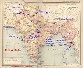
ΣύνοψηThis is a low-resolution (40% of original) scanned image of the map, "Politial Divisions of the Indian Empire" from the Imperial Gazeteer of India (volume 26, Atlas), published by the Oxford University Press, 1909. The map image was scanned and then annotated by me (Sanjay Tiwari 18:24, 30 September 2006 (UTC)) |
||||||
| Πηγή | Έργο αυτού που το ανεβάζει | ||||||
| Δημιουργός | User Sanjay Tiwari on en.wikipedia | ||||||
| Άδεια (Επαναχρησιμοποίηση αυτού του αρχείου) |
|
||||||
| άλλες εκδόσεις |
Originally from en.wikipedia; description page is (was) here * 18:24, 30 September 2006 [[:en:User:Sanjay Tiwari|Sanjay Tiwari]] 880×680 (126,459 bytes) <span class="comment">(This is a low-resolution (40% of original) scanned image of the map, "Politial Divisions of the Indian Empire" from the ''Imperial Gazeteer of India'' (volume 26, Atlas), published by the Oxford University Press, 1909. The map image was scanned and the)</span> |
||||||
(Uploaded using CommonsHelper or PushForCommons)
Αδειοδότηση
|
Αυτό το έργο είναι κοινό κτήμα στη χώρα προέλευσής του και άλλες χώρες και περιοχές όπου η διάρκεια πνευματικών δικαιωμάτων είναι όσο η ζωή του δημιουργού και μέχρι 70 χρόνια μετά ή λιγότερο.
| |
| Αυτό το αρχείο έχει χαρακτηριστεί ως απαλλαγμένο από γνωστούς περιορισμούς βάσει της νομοθεσίας περί πνευματικής ιδιοκτησίας, περιλαμβανομένων όλων των συναφών και συγγενικών δικαιωμάτων. | |
Καταγραφές ανεβασμάτων πρωτότυπου αρχείου
- 2007-05-14 07:25 Kintetsubuffalo 802×663× (117058 bytes) trimmed to make edges equal
- 2006-09-30 18:24 Sanjay Tiwari 880×680× (126459 bytes) This is a low-resolution (40% of original) scanned image of the map, "Politial Divisions of the Indian Empire" from the ''Imperial Gazeteer of India'' (volume 26, Atlas), published by the Oxford University Press, 1909. The map image was scanned and the
Ιστορικό αρχείου
Κλικάρετε σε μια ημερομηνία/ώρα για να δείτε το αρχείο όπως εμφανιζόταν εκείνη τη στιγμή.
| Ώρα/Ημερομ. | Μικρογραφία | Διαστάσεις | Χρήστης | Σχόλια | |
|---|---|---|---|---|---|
| τελευταία | 13:39, 28 Μαρτίου 2016 | | 802 × 663 (114 KB) | OgreBot | (BOT): Uploading old version of file from en.wikipedia; originally uploaded on 2007-05-14 07:25:05 by Kintetsubuffalo |
| 13:39, 28 Μαρτίου 2016 |  | 880 × 680 (123 KB) | OgreBot | (BOT): Uploading old version of file from en.wikipedia; originally uploaded on 2006-09-30 18:24:12 by Sanjay Tiwari | |
| 20:17, 13 Νοεμβρίου 2006 |  | 776 × 600 (95 KB) | Chechof | {{Information| |Description= == Summary == This is a low-resolution (40% of original) scanned image of the map, "Politial Divisions of the Indian Empire" from the ''Imperial Gazeteer of India'' (volume 26, Atlas), published by the Oxford University Press |
Συνδέσεις αρχείου
Τα παρακάτω λήμματα συνδέουν σε αυτό το αρχείο:
Καθολική χρήση αρχείου
Τα ακόλουθα άλλα wiki χρησιμοποιούν αυτό το αρχείο:
- Χρήση σε ca.wikipedia.org
- Χρήση σε en.wikipedia.org
- Χρήση σε es.wikipedia.org
- Χρήση σε gl.wikipedia.org
- Χρήση σε hi.wikipedia.org
- Χρήση σε hu.wikipedia.org
- Χρήση σε ja.wikipedia.org
- Χρήση σε pt.wikipedia.org
- Χρήση σε tt.wikipedia.org
- Χρήση σε vi.wikipedia.org