Αρχείο:Mazama bathymetry survey map.jpg
Δεν διατίθεται υψηλότερη ανάλυση.
Mazama_bathymetry_survey_map.jpg (600 × 345 εικονοστοιχεία, μέγεθος αρχείου: 61 KB, τύπος MIME: image/jpeg)
|
|
Αυτό το αρχείο και η περιγραφή του προέρχονται από το Wikimedia Commons. Οι πληροφορίες από την σελίδα περιγραφής του εκεί εμφανίζονται παρακάτω. |
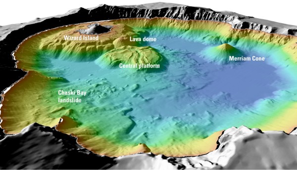
| Περιγραφή |
English: "Details of features beneath the surface of Crater Lake constructed using data from the 2000 bathymetry survey. Colors range from orange to blue with increasing water depth." |
| Πηγή | "Mount Mazama and Crater Lake: Growth and Destruction of a Cascade Volcano" |
| Δημιουργός | U.S. Geological Survey |
Αδειοδότηση
This image is in the public domain in the United States because it only contains materials that originally came from the United States Geological Survey, an agency of the United States Department of the Interior. For more information, see the official USGS copyright policy.
|
Καταγραφές ανεβασμάτων πρωτότυπου αρχείου
The original description page was here. All following user names refer to en.wikipedia.
- 2004-05-18 06:41 Mav 600×345× (62232 bytes) [[USGS]] image from [http://geopubs.wr.usgs.gov/fact-sheet/fs092-02/] <br><br>{{msg:PD}}
Ιστορικό αρχείου
Κλικάρετε σε μια ημερομηνία/ώρα για να δείτε το αρχείο όπως εμφανιζόταν εκείνη τη στιγμή.
| Ώρα/Ημερομ. | Μικρογραφία | Διαστάσεις | Χρήστης | Σχόλια | |
|---|---|---|---|---|---|
| τελευταία | 06:26, 13 Ιουλίου 2009 | | 600 × 345 (61 KB) | ZabMilenko | {{Information |Description={{en|en:USGS image from [http://geopubs.wr.usgs.gov/fact-sheet/fs092-02/] en:Category:Images of Oregon}} |Source=Transferred from [http://en.wikipedia.org en.wikipedia]; transferred to Commons by [[User:ZabMilenko |
Συνδέσεις αρχείου
Τα παρακάτω λήμματα συνδέουν σε αυτό το αρχείο:
Καθολική χρήση αρχείου
Τα ακόλουθα άλλα wiki χρησιμοποιούν αυτό το αρχείο:
- Χρήση σε bh.wikipedia.org
- Χρήση σε en.wikipedia.org
- Χρήση σε eo.wikipedia.org
- Χρήση σε es.wikipedia.org
- Χρήση σε fa.wikipedia.org
- Χρήση σε it.wikipedia.org
- Χρήση σε ja.wikipedia.org
- Χρήση σε lv.wikipedia.org
- Χρήση σε ms.wikipedia.org
- Χρήση σε simple.wikipedia.org
- Χρήση σε sl.wikipedia.org
- Χρήση σε ur.wikipedia.org
- Χρήση σε vi.wikipedia.org
- Χρήση σε www.wikidata.org
- Χρήση σε zh.wikipedia.org