Αρχείο:Nile River Delta at Night.JPG

Εικόνα σε υψηλότερη ανάλυση (4.256 × 2.832 εικονοστοιχεία, μέγεθος αρχείου: 2,05 MB, τύπος MIME: image/jpeg)
|
|
Αυτό το αρχείο και η περιγραφή του προέρχονται από το Wikimedia Commons. Οι πληροφορίες από την σελίδα περιγραφής του εκεί εμφανίζονται παρακάτω. |
Σύνοψη
| Περιγραφή |
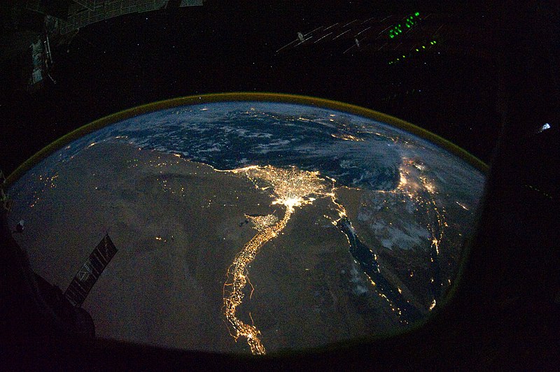
English: In this view of Egypt, we see a population almost completely concentrated along the Nile Valley, just a small percentage of the country’s land area. The Nile River and its delta look like a brilliant, long-stemmed flower in this astronaut photograph of the south-eastern Mediterranean Sea, as seen from the International Space Station. The Cairo metropolitan area forms a particularly bright base of the flower. The smaller cities and towns within the Nile Delta tend to be hard to see amidst the dense agricultural vegetation during the day. However, these settled areas and the connecting roads between them become clearly visible at night. Likewise, urbanized regions and infrastructure along the Nile River becomes apparent.
Another brightly lit region is visible along the eastern coastline of the Mediterranean—the Tel-Aviv metropolitan area in Israel (image right). To the east of Tel-Aviv lies Amman, Jordan. The two major water bodies that define the western and eastern coastlines of the Sinai Peninsula—the Gulf of Suez and the Gulf of Aqaba—are outlined by lights along their coastlines (image lower right). The city lights of Paphos, Limassol, Larnaca, and Nicosia are visible on the island of Cyprus (image top). Scattered blue-grey clouds cover the Mediterranean Sea and the Sinai, while much of north-eastern Africa is cloud-free. A thin yellow-brown band tracing the Earth’s curvature at image top is air-glow, a faint band of light emission that results from the interaction of atmospheric atoms and molecules with solar radiation at approximately 100 kilometres altitude. |
| Ημερομηνία | |
| Πηγή | NASA Earth Observatory |
| Δημιουργός | ISS Expedition 25 crew |
| άλλες εκδόσεις |
Derivative works of this file: Nile River Delta at Night cropped.JPG Also see http://earthobservatory.nasa.gov/IOTD/view.php?id=46820&src=eoa-iotd for annotated version, with features identified. |
| Camera location | | View this and other nearby images on: OpenStreetMap |
|---|
This image or video was catalogued by Johnson Space Center of the United States National Aeronautics and Space Administration (NASA) under Photo ID: ISS025-E-9858. This tag does not indicate the copyright status of the attached work. A normal copyright tag is still required. See Commons:Licensing. Other languages:
|
Image acquired with a Nikon D3S digital camera using a 16 mm lens, and is provided by the ISS Crew Earth Observations experiment and Image Science & Analysis Laboratory, Johnson Space Center.
Αδειοδότηση
| Αυτό το αρχείο είναι κοινό κτήμα γιατί δημιουργήθηκε από την NASA. Η πολιτική πνευματικής ιδιοκτησίας της NASA δηλώνει ότι «Το υλικό της NASA δεν προστατεύεται από copyright εκτός αν αναφέρεται». (Σελίδα με την πολιτική πνευματικής ιδιοκτησίας της NASA ή Πολιτική Χρήσης Εικόνων του JPL). | ||
 |
Προσοχή:
|
| Annotations | This image is annotated: View the annotations at Commons |
Ιστορικό αρχείου
Κλικάρετε σε μια ημερομηνία/ώρα για να δείτε το αρχείο όπως εμφανιζόταν εκείνη τη στιγμή.
| Ώρα/Ημερομ. | Μικρογραφία | Διαστάσεις | Χρήστης | Σχόλια | |
|---|---|---|---|---|---|
| τελευταία | 12:51, 8 Νοεμβρίου 2010 | | 4.256 × 2.832 (2,05 MB) | Originalwana | {{Information |Description={{en|1=In this view of Egypt, we see a population almost completely concentrated along the Nile Valley, just a small percentage of the country’s land area. The Nile River and its delta look like a brilliant, long-stemmed flow |
Συνδέσεις αρχείου
Τα παρακάτω λήμματα συνδέουν σε αυτό το αρχείο:
Καθολική χρήση αρχείου
Τα ακόλουθα άλλα wiki χρησιμοποιούν αυτό το αρχείο:
- Χρήση σε af.wikipedia.org
- Χρήση σε arz.wikipedia.org
- Χρήση σε av.wikipedia.org
- Χρήση σε bg.wikipedia.org
- Χρήση σε bs.wikipedia.org
- Χρήση σε cs.wikipedia.org
- Χρήση σε en.wikipedia.org
- Χρήση σε en.wiktionary.org
- Χρήση σε es.wikipedia.org
- Χρήση σε ha.wikipedia.org
- Χρήση σε he.wikipedia.org
- Χρήση σε incubator.wikimedia.org
- Χρήση σε ln.wikipedia.org
- Χρήση σε ml.wikipedia.org
- Χρήση σε no.wikipedia.org
- Χρήση σε sd.wikipedia.org
- Χρήση σε sk.wikipedia.org
- Χρήση σε sl.wikipedia.org
- Χρήση σε sq.wikipedia.org
- Χρήση σε sq.wikiquote.org
- Χρήση σε sr.wikipedia.org
- Χρήση σε sv.wikipedia.org
- Χρήση σε ta.wikipedia.org
- Χρήση σε th.wikipedia.org
- Χρήση σε tr.wikipedia.org
- Χρήση σε uk.wikipedia.org
- Χρήση σε ur.wikipedia.org
- Χρήση σε vi.wikipedia.org