Αρχείο:Operation Dragoon - map.jpg
Εικόνα σε υψηλότερη ανάλυση (1.265 × 965 εικονοστοιχεία, μέγεθος αρχείου: 1,94 MB, τύπος MIME: image/jpeg)
|
|
Αυτό το αρχείο και η περιγραφή του προέρχονται από το Wikimedia Commons. Οι πληροφορίες από την σελίδα περιγραφής του εκεί εμφανίζονται παρακάτω. |

|
This military map image could be re-created using vector graphics as an SVG file. This has several advantages; see Commons:Media for cleanup for more information. If an SVG form of this image is available, please upload it and afterwards replace this template with
{{vector version available|new image name}}.
It is recommended to name the SVG file “Operation Dragoon - map.svg”—then the template Vector version available (or Vva) does not need the new image name parameter. |


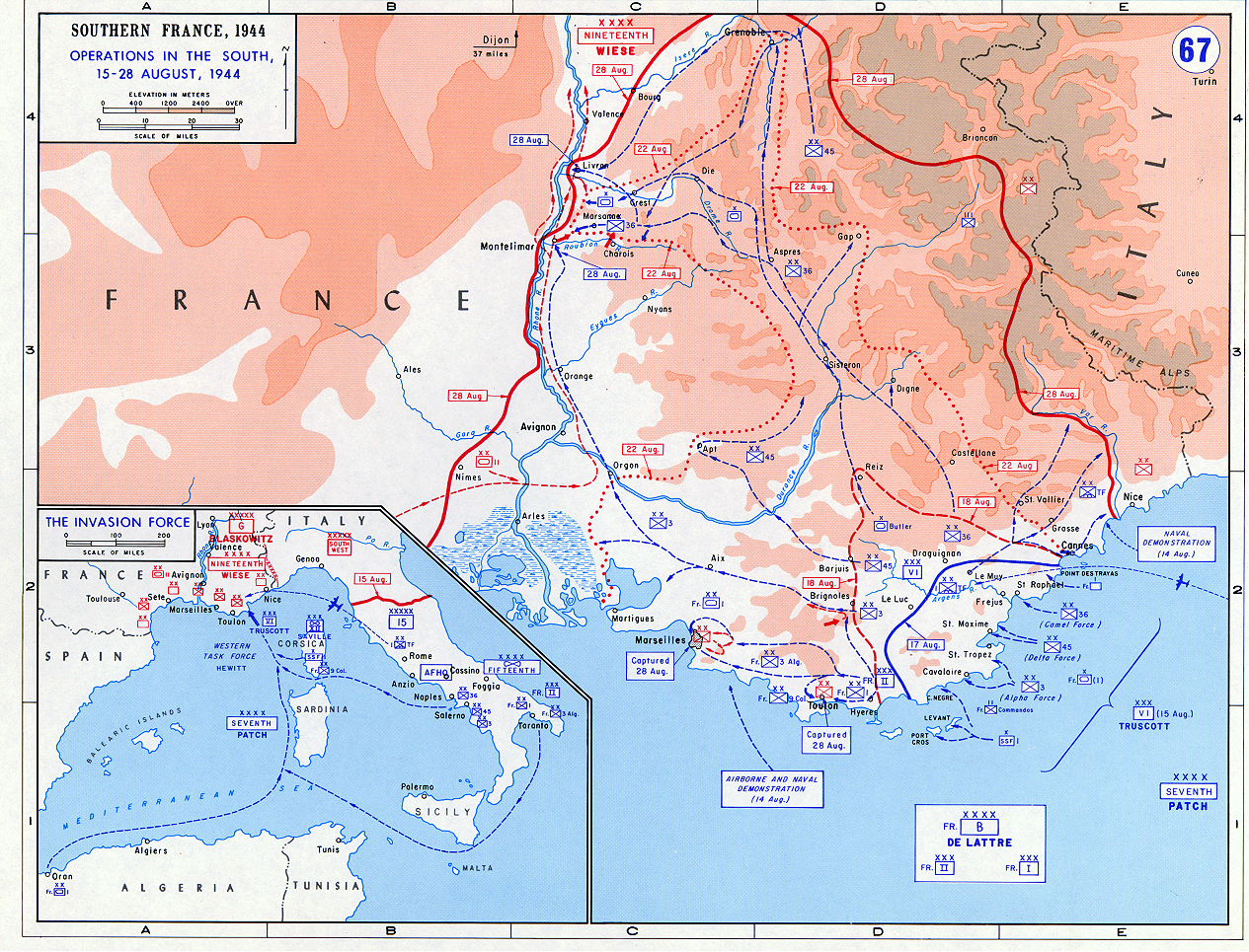
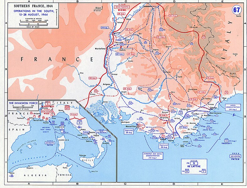
- Description: Operation Dragoon - Aug. 1944
- Source: www.dean.usma.edu
- Background information:
In 1938 the predecessors of what is today The Department of History at the United States Military Academy began developing a series of campaign atlases to aid in teaching cadets a course entitled, "History of the Military Art." Since then, the Department has produced over six atlases and more than one thousand maps, encompassing not only America’s wars but global conflicts as well.
In keeping abreast with today's technology, the Department of History is providing these maps on the internet as part of the department's outreach program. The maps were created by the United States Military Academy’s Department of History and are the digital versions from the atlases printed by the United States Defense Printing Agency. We gratefully acknowledge the accomplishments of the department's former cartographer, Mr. Edward J. Krasnoborski, along with the works of our present cartographer, Mr. Frank Martini.
Please be aware that these maps are large in file size and may require substantial download times.
Notes
- The indication "Dijon 37 miles" in the top middle of the map is most likely an error and should read "Lyon 37 miles".
This file is a work of a U.S. Army soldier or employee, taken or made as part of that person's official duties. As a work of the U.S. federal government, it is in the public domain in the United States.
|
 |
Ιστορικό αρχείου
Κλικάρετε σε μια ημερομηνία/ώρα για να δείτε το αρχείο όπως εμφανιζόταν εκείνη τη στιγμή.
| Ώρα/Ημερομ. | Μικρογραφία | Διαστάσεις | Χρήστης | Σχόλια | |
|---|---|---|---|---|---|
| τελευταία | 16:50, 23 Μαΐου 2018 | | 1.265 × 965 (1,94 MB) | Hohum | Colour adjust |
| 17:53, 14 Σεπτεμβρίου 2005 |  | 1.265 × 965 (1,93 MB) | W.wolny |
Συνδέσεις αρχείου
Τα παρακάτω λήμματα συνδέουν σε αυτό το αρχείο:
Καθολική χρήση αρχείου
Τα ακόλουθα άλλα wiki χρησιμοποιούν αυτό το αρχείο:
- Χρήση σε azb.wikipedia.org
- Χρήση σε bg.wikipedia.org
- Χρήση σε ca.wikipedia.org
- Χρήση σε cs.wikipedia.org
- Χρήση σε da.wikipedia.org
- Χρήση σε de.wikipedia.org
- Χρήση σε en.wikipedia.org
- Χρήση σε eo.wikipedia.org
- Χρήση σε es.wikipedia.org
- Χρήση σε fa.wikipedia.org
- Χρήση σε fi.wikipedia.org
- Χρήση σε fr.wikipedia.org
- Χρήση σε he.wikipedia.org
- Χρήση σε hu.wikipedia.org
- Χρήση σε id.wikipedia.org
- Χρήση σε it.wikipedia.org
- Χρήση σε ja.wikipedia.org
- Χρήση σε ko.wikipedia.org
- Χρήση σε nl.wikipedia.org
- Χρήση σε no.wikipedia.org
- Χρήση σε pl.wikipedia.org
- Χρήση σε ro.wikipedia.org
- Χρήση σε ru.wikipedia.org
- Χρήση σε sh.wikipedia.org
- Χρήση σε sk.wikipedia.org
- Χρήση σε sl.wikipedia.org
- Χρήση σε sv.wikipedia.org
- Χρήση σε ta.wikipedia.org
- Χρήση σε th.wikipedia.org
- Χρήση σε tr.wikipedia.org
- Χρήση σε uk.wikipedia.org
- Χρήση σε www.wikidata.org
- Χρήση σε zh.wikipedia.org