Αρχείο:Picoduartemap.jpg

Μέγεθος αυτής της προεπισκόπησης: 643 × 599 εικονοστοιχεία . Άλλες αναλύσεις: 258 × 240 εικονοστοιχεία | 515 × 480 εικονοστοιχεία | 824 × 768 εικονοστοιχεία | 1.099 × 1.024 εικονοστοιχεία | 2.197 × 2.048 εικονοστοιχεία | 3.280 × 3.057 εικονοστοιχεία.
Εικόνα σε υψηλότερη ανάλυση (3.280 × 3.057 εικονοστοιχεία, μέγεθος αρχείου: 1,5 MB, τύπος MIME: image/jpeg)
|
|
Αυτό το αρχείο και η περιγραφή του προέρχονται από το Wikimedia Commons. Οι πληροφορίες από την σελίδα περιγραφής του εκεί εμφανίζονται παρακάτω. |
Σύνοψη

|
Αυτό το αρχείο μεταφέρθηκε στα Wikimedia Commons από en.wikipedia μέσω ενός αυτόματου μποτ. Όλες οι πληροφορίες που το συνόδευαν διατηρούνται. Χρειάζεται έλεγχο. Επιπλέον, μπορει να υπάρχουν σφάλματα σε κάποιο ή όλα τα πεδία πληροφοριών: οι πληροφορίες αυτού του αρχείου δεν θα πρέπει να θεωρούνται αξιόπιστες και το αρχείο δεν θα πρέπει να χρησιμοποιείται μέχρι να ελεγχθεί και να γίνουν τυχόν απαραίτητες διορθώσεις. Όταν ολοκληρωθεί ο έλεγχος, αυτό το πρότυπο θα πρέπει να αφαιρεθεί. Για λεπτομέρειες σχετικά με αυτό το αρχείο, δείτε παρακάτω. Ελέγξτε το τώρα! |
| Περιγραφή |
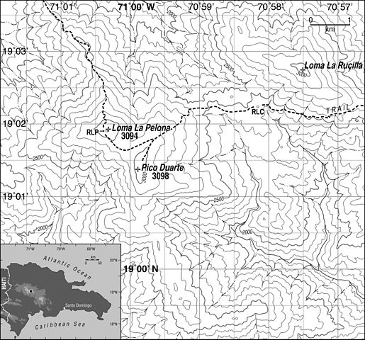
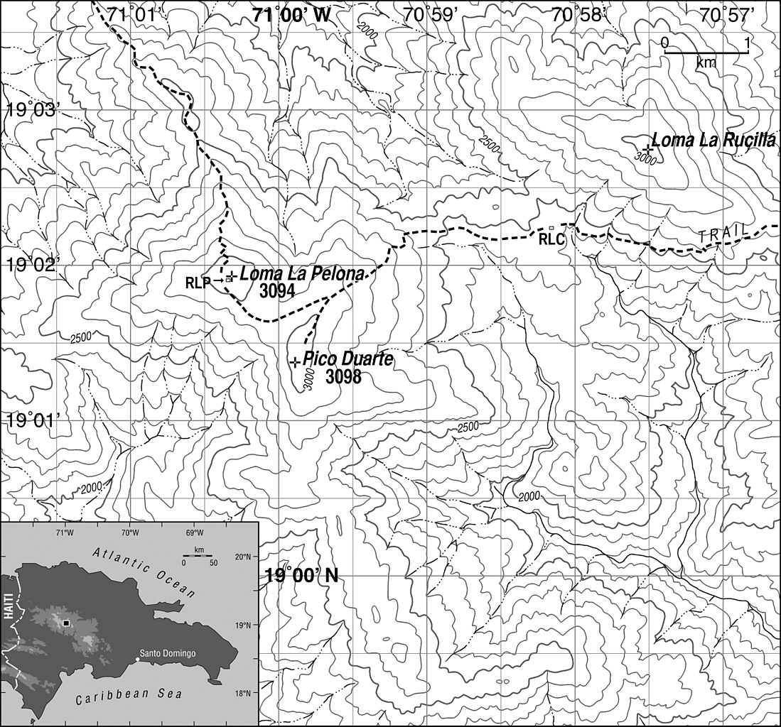
English: Map general area surrounding Pico Duarte. Contour interval is 100 m. RLP: Refugio La Pelona. RLC: Refugio La Compartición. Inset shows Dominican Republic with location of main map highlighted. Datum is WGS 84; projection is Universal Transverse Mercator (19N). Trails and shelters were mapped using GPS and aerial photography; topography and streams were adjusted from the Lamedero (NW, 1969), Manabao (NE, 1969), Juan de Herrera (SW, 1969) and Gajo de Monte (SE, 1962) 1:50000 scale topographic quadrangles published by the U.S. Army Map Service and compiled by that group in collaboration with the Instituto Cartográfico Militar, the Instituto Cartográfico Universitario and the Inter-American Geodetic Survey. |
| Ημερομηνία | |
| Πηγή | Kenneth H. Orvis |
| Δημιουργός | Kenneth H. Orvis |
| Άδεια (Επαναχρησιμοποίηση αυτού του αρχείου) |
Use is allowed if attribution of author is given |
| άλλες εκδόσεις | Other versions are copyrighted by the journals they were published in. Version used is author's own initial sketch. |
Αδειοδότηση
Το αρχείο διανέμεται υπό την άδεια Creative Commons Αναφορά προέλευσης 1.0 Γενική
Απόδοση: Image may be used if name of author is given
- Είστε ελεύθερος:
- να μοιραστείτε – να αντιγράψετε, διανέμετε και να μεταδώσετε το έργο
- να διασκευάσετε – να τροποποιήσετε το έργο
- Υπό τις ακόλουθες προϋποθέσεις:
- αναφορά προέλευσης – Θα πρέπει να κάνετε κατάλληλη αναφορά, να παρέχετε σύνδεσμο για την άδεια και να επισημάνετε εάν έγιναν αλλαγές. Μπορείτε να το κάνετε με οποιοδήποτε αιτιολογήσιμο λόγο, χωρίς όμως να εννοείται με οποιονδήποτε τρόπο ότι εγκρίνουν εσάς ή τη χρήση του έργου από εσάς.
Καταγραφές ανεβασμάτων πρωτότυπου αρχείου
Transferred from en.wikipedia to Commons by IngerAlHaosului using CommonsHelper.
The original description page was here. All following user names refer to en.wikipedia.
- 2008-04-04 11:29 Cuyaya 3280×3057× (1571739 bytes) {{Information |Description=Map showing locations discussed in text. Contour interval is 100 m. RLP: Refugio La Pelona. RLC: Refugio La Compartición. Inset shows Dominican Republic with location of main map highlighted. Datum is WGS 84; projection is Univ
Ιστορικό αρχείου
Κλικάρετε σε μια ημερομηνία/ώρα για να δείτε το αρχείο όπως εμφανιζόταν εκείνη τη στιγμή.
| Ώρα/Ημερομ. | Μικρογραφία | Διαστάσεις | Χρήστης | Σχόλια | |
|---|---|---|---|---|---|
| τελευταία | 13:28, 31 Ιανουαρίου 2010 | | 3.280 × 3.057 (1,5 MB) | File Upload Bot (Magnus Manske) | {{BotMoveToCommons|en.wikipedia|year={{subst:CURRENTYEAR}}|month={{subst:CURRENTMONTHNAME}}|day={{subst:CURRENTDAY}}}} {{Information |Description={{en|Map general area surrounding en:Pico Duarte. Contour interval is 100 m. RLP: Refugio La Pelona. R |
Συνδέσεις αρχείου
Τα παρακάτω λήμματα συνδέουν σε αυτό το αρχείο:
Καθολική χρήση αρχείου
Τα ακόλουθα άλλα wiki χρησιμοποιούν αυτό το αρχείο:
- Χρήση σε en.wikipedia.org
- Χρήση σε pt.wikipedia.org