Αρχείο:RomaCloacaMaximaPercorso.png
Εικόνα σε υψηλότερη ανάλυση (319 × 739 εικονοστοιχεία, μέγεθος αρχείου: 276 KB, τύπος MIME: image/png)
|
|
Αυτό το αρχείο και η περιγραφή του προέρχονται από το Wikimedia Commons. Οι πληροφορίες από την σελίδα περιγραφής του εκεί εμφανίζονται παρακάτω. |
Σύνοψη
| Περιγραφή |
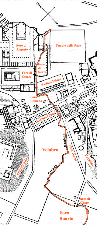
English: Zoom in of Image:Map of downtown Rome during the Roman Empire large-annotated.jpg with Cloaca Massima highlighted. Old map of Foro di Nerva (in Northeast upside in this map) before construction of Via dei Fori Imperiali. Foro Boario.
Français : Zoom sur le tracé de la Cloaca Maxima sur le site des forums impériaux depuis le forum Boarium.
Italiano: Pianta del centro di Roma di età imperiale con il percorso della Cloaca Maxima (ripresa daen.wikipedia e modificata pel'utente) |
||||
| Ημερομηνία | |||||
| Πηγή | Italian wikipedia, edited by MM and by User:DieBuche | ||||
| Δημιουργός | DieBuche | ||||
| Άδεια (Επαναχρησιμοποίηση αυτού του αρχείου) |
|
||||
Αδειοδότηση
|
Αυτό το έργο είναι κοινό κτήμα στη χώρα προέλευσής του και άλλες χώρες και περιοχές όπου η διάρκεια πνευματικών δικαιωμάτων είναι όσο η ζωή του δημιουργού και μέχρι 70 χρόνια μετά ή λιγότερο.
| |
| Αυτό το αρχείο έχει χαρακτηριστεί ως απαλλαγμένο από γνωστούς περιορισμούς βάσει της νομοθεσίας περί πνευματικής ιδιοκτησίας, περιλαμβανομένων όλων των συναφών και συγγενικών δικαιωμάτων. | |
| Annotations | This image is annotated: View the annotations at Commons |
Ιστορικό αρχείου
Κλικάρετε σε μια ημερομηνία/ώρα για να δείτε το αρχείο όπως εμφανιζόταν εκείνη τη στιγμή.
| Ώρα/Ημερομ. | Μικρογραφία | Διαστάσεις | Χρήστης | Σχόλια | |
|---|---|---|---|---|---|
| τελευταία | 10:28, 4 Μαρτίου 2007 | | 319 × 739 (276 KB) | DieBuche | ;Description {{english}}: Zoom in of Image:Map of downtown Rome during the Roman Empire large.jpg with ''Cloca Massima'' highlighted. {{italian}}: Pianta del centro di Roma di età imperiale con il percorso della Cloaca Maxima (ripresa daen.wikipedia |
Συνδέσεις αρχείου
Τα παρακάτω λήμματα συνδέουν σε αυτό το αρχείο:
Καθολική χρήση αρχείου
Τα ακόλουθα άλλα wiki χρησιμοποιούν αυτό το αρχείο:
- Χρήση σε be.wikipedia.org
- Χρήση σε de.wikipedia.org
- Χρήση σε es.wikipedia.org
- Χρήση σε fr.wikipedia.org
- Χρήση σε hr.wikipedia.org
- Χρήση σε it.wikipedia.org
- Χρήση σε la.wikipedia.org
- Χρήση σε pt.wikipedia.org
- Χρήση σε ro.wikipedia.org
- Χρήση σε ru.wikipedia.org
- Χρήση σε sh.wikipedia.org
- Χρήση σε uk.wikipedia.org