Αρχείο:RomaniaBorderHistoryAnnimation 1859-2010.gif
Μέγεθος αυτής της προεπισκόπησης: 696 × 599 εικονοστοιχεία . Άλλες αναλύσεις: 279 × 240 εικονοστοιχεία | 558 × 480 εικονοστοιχεία | 1.000 × 861 εικονοστοιχεία.
Εικόνα σε υψηλότερη ανάλυση (1.000 × 861 εικονοστοιχεία, μέγεθος αρχείου: 162 KB, τύπος MIME: image/gif, κυκλικά επαναλαμβανόμενο, 12 καρέ, 36 s)
|
|
Αυτό το αρχείο και η περιγραφή του προέρχονται από το Wikimedia Commons. Οι πληροφορίες από την σελίδα περιγραφής του εκεί εμφανίζονται παρακάτω. |
Σύνοψη
| Περιγραφή |
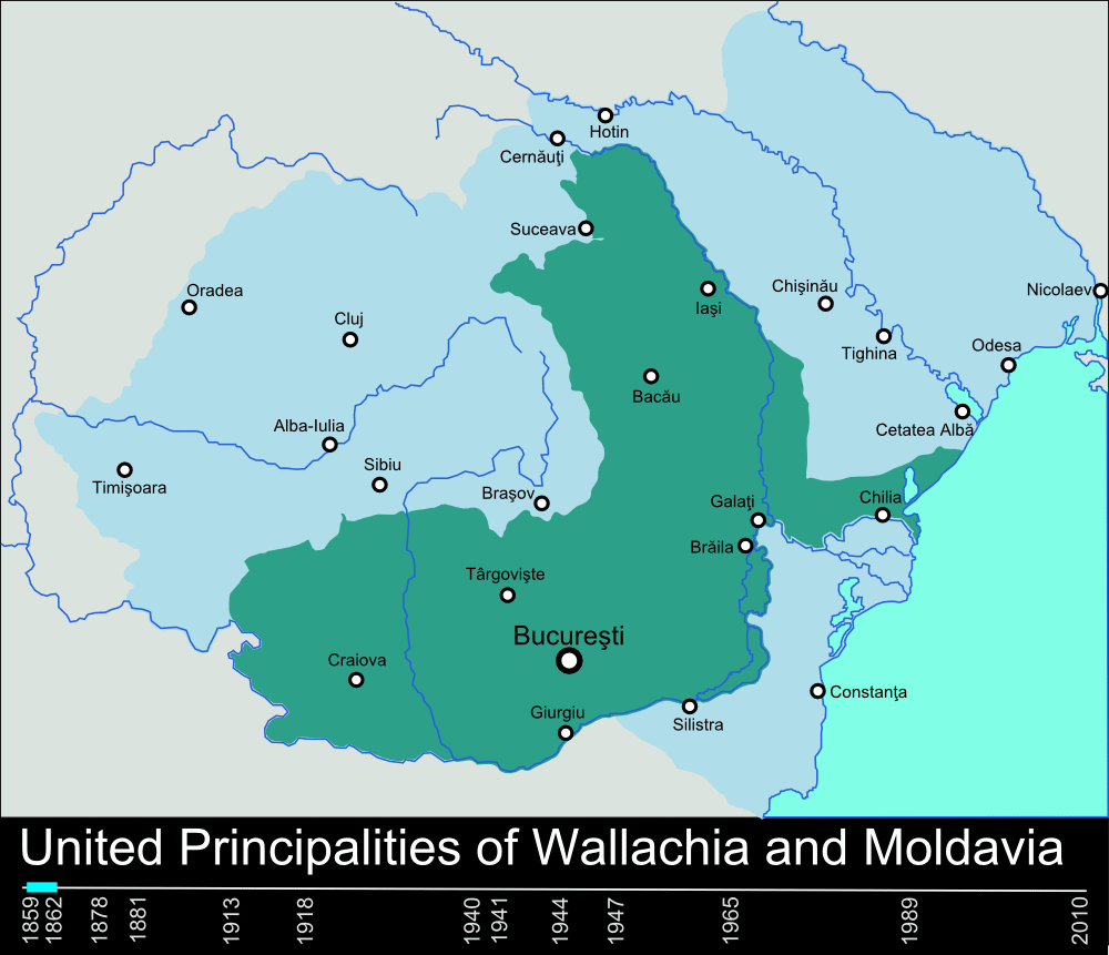
English: Timeline of the borders of Romania between 1859 and 2010. |
| Ημερομηνία | 11 Ιανουαρίου 2010 (original upload date) |
| Πηγή | self-made, individual frames were based on maps from here: Atlas of Romania. (I could upload standalone maps for each period of time, if needed. Contact me for that.). |
| Δημιουργός | User:Scooter20 |
| άλλες εκδόσεις | Derivative works of this file: RomaniaBorderHistoryAnnimation 1859-2010 es.gif |
Αδειοδότηση
| Το έργο αυτό έχει απελευθερωθεί στην public domain από τον δημιουργό του, Scooter20 at Αγγλικά Βικιπαίδεια. Αυτό ισχύει σε όλο τον κόσμο. Σε ορισμένες χώρες αυτό μπορεί να μην είναι νομικά εφικτό. Αν ναι: Scooter20 Παραχωρώ σε οποιονδήποτε το δικαίωμα να χρησιμοποιήσει αυτό το έργο "για οποιονδήποτε σκοπό", χωρίς κανέναν όρο, εκτός και αν τέτοιοι όροι τίθενται από την νομοθεσία |
Καταγραφές ανεβασμάτων πρωτότυπου αρχείου
Transferred from en.wikipedia to Commons by Rowanwindwhistler using CommonsHelper.
The original description page was here. All following user names refer to en.wikipedia.
- 2010-01-11 22:17 Scooter20 1000×861× (166899 bytes) Reverted to version as of 12:48, 31 December 2009
- 2010-01-10 21:53 Alexandrey 1000×861× (152174 bytes) Reverted to version as of 19:31, 30 December 2009
- 2010-01-10 21:52 Alexandrey 1000×861× (166932 bytes) Reverted to version as of 12:29, 31 December 2009
- 2009-12-31 12:48 Scooter20 1000×861× (166899 bytes) fixed Hertza region, which didn't belong to Romania after 1944
- 2009-12-31 12:29 Scooter20 1000×861× (166932 bytes) Added new intervals: 1862-1878, 1878-1881 - United Romanian Principalities 1947-1965 - People's Republic of Romania
- 2009-12-31 00:57 Scooter20 1000×861× (153234 bytes) fixed location of the city of Sibiu
- 2009-12-30 19:31 Scooter20 1000×861× (152174 bytes) Timeline of the borders of Romania between 1859 and 2010.
Ιστορικό αρχείου
Κλικάρετε σε μια ημερομηνία/ώρα για να δείτε το αρχείο όπως εμφανιζόταν εκείνη τη στιγμή.
| Ώρα/Ημερομ. | Μικρογραφία | Διαστάσεις | Χρήστης | Σχόλια | |
|---|---|---|---|---|---|
| τελευταία | 22:02, 9 Μαρτίου 2012 | | 1.000 × 861 (162 KB) | Scooter20 | Better colors! |
| 16:07, 8 Σεπτεμβρίου 2010 |  | 1.000 × 861 (168 KB) | Mihai Andrei | Corrected the name of the city of Cluj for the period until 1975. | |
| 00:09, 4 Σεπτεμβρίου 2010 |  | 1.000 × 861 (163 KB) | Anonimizat XXX | (I tried to revert to the version from april 2010 but it didn't work, so I've decided to manually upload again) | |
| 00:02, 4 Σεπτεμβρίου 2010 |  | 1.000 × 861 (163 KB) | Anonimizat XXX | Reverted to version as of 20:45, 21 April 2010 (animation broken, also, the name of Cluj is actually Cluj-Napoca as the original gif indicate) | |
| 18:02, 9 Αυγούστου 2010 |  | 1.000 × 861 (73 KB) | Mihai Andrei | Corrected the name of the city of Cluj. | |
| 20:45, 21 Απριλίου 2010 |  | 1.000 × 861 (163 KB) | File Upload Bot (Magnus Manske) | {{BotMoveToCommons|en.wikipedia|year={{subst:CURRENTYEAR}}|month={{subst:CURRENTMONTHNAME}}|day={{subst:CURRENTDAY}}}} {{Information |Description={{en|Timeline of the borders of Romania between 1859 and 2010.<br/> == Other versions == [[:en:Image:Flag_of |
Συνδέσεις αρχείου
Τα παρακάτω λήμματα συνδέουν σε αυτό το αρχείο:
Καθολική χρήση αρχείου
Τα ακόλουθα άλλα wiki χρησιμοποιούν αυτό το αρχείο:
- Χρήση σε af.wikipedia.org
- Χρήση σε ar.wikipedia.org
- Χρήση σε ary.wikipedia.org
- Χρήση σε ast.wikipedia.org
- Χρήση σε azb.wikipedia.org
- Χρήση σε bcl.wikipedia.org
- Χρήση σε da.wikipedia.org
- Χρήση σε de.wikipedia.org
- Χρήση σε en.wikipedia.org
- Romania
- History of Romania
- Former administrative divisions of Romania
- Kingdom of Romania
- Romanians
- Administrative divisions of Romania
- Portal:Romania
- User:Scooter20
- Union of Transylvania with Romania
- User:Iadrian yu
- User talk:Iadrian yu/Archive April,2010
- Territorial evolution of Romania
- 2010 in Romania
- Χρήση σε et.wikipedia.org
- Χρήση σε eu.wikipedia.org
- Χρήση σε fa.wikipedia.org
- Χρήση σε fi.wikipedia.org
- Χρήση σε it.wikipedia.org
- Χρήση σε ja.wikipedia.org
- Χρήση σε ka.wikipedia.org
- Χρήση σε lv.wikipedia.org
- Χρήση σε mk.wikipedia.org
- Χρήση σε no.wikipedia.org
- Χρήση σε pt.wikipedia.org
- Χρήση σε ro.wikibooks.org
- Χρήση σε ru.wikipedia.org
- Χρήση σε sl.wikipedia.org
- Χρήση σε sr.wikipedia.org
Δείτε περισσότερη καθολική χρήση αυτού του αρχείου.