Αρχείο:SDUK - Turkey II. Containing the Northern Part of Greece.jpg

Μέγεθος αυτής της προεπισκόπησης: 800 × 544 εικονοστοιχεία . Άλλες αναλύσεις: 320 × 217 εικονοστοιχεία | 640 × 435 εικονοστοιχεία | 1.024 × 696 εικονοστοιχεία | 1.280 × 870 εικονοστοιχεία | 2.560 × 1.739 εικονοστοιχεία | 5.764 × 3.916 εικονοστοιχεία.
Εικόνα σε υψηλότερη ανάλυση (5.764 × 3.916 εικονοστοιχεία, μέγεθος αρχείου: 3,96 MB, τύπος MIME: image/jpeg)
|
|
Αυτό το αρχείο και η περιγραφή του προέρχονται από το Wikimedia Commons. Οι πληροφορίες από την σελίδα περιγραφής του εκεί εμφανίζονται παρακάτω. |
Σύνοψη
| Περιγραφή |
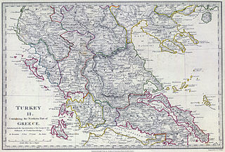
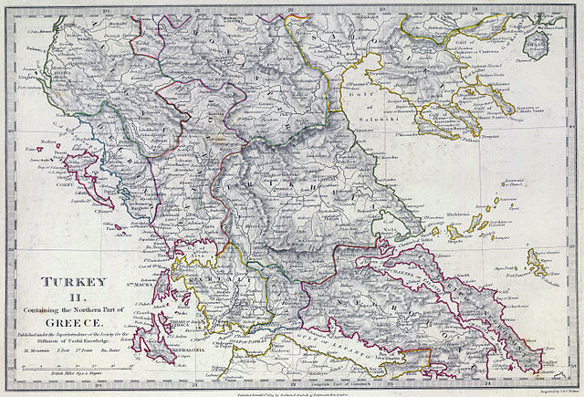
English: The southern provinces of European Turkey (Ottoman Empire) in 1829, including the northern portions of independent Greece (not differentiated in this map, which shows the pre-Greek War of Independence administrative boundaries). Published under the superintendence of the Society for the Diffusion of Useful Knowledge. |
| Ημερομηνία | |
| Πηγή | David Rumsey Historical Map Collection |
| Δημιουργός | Engraved by J. & C. Walker. Published September 1st. 1829 by Baldwin & Cradock, 47 Paternoster Row, London. (London: Chapman & Hall, 1844) |
Αδειοδότηση
|
Αυτό το έργο είναι κοινό κτήμα στη χώρα προέλευσής του και άλλες χώρες και περιοχές όπου η διάρκεια πνευματικών δικαιωμάτων είναι όσο η ζωή του δημιουργού και μέχρι 100 χρόνια μετά ή λιγότερο. | |
| Αυτό το αρχείο έχει χαρακτηριστεί ως απαλλαγμένο από γνωστούς περιορισμούς βάσει της νομοθεσίας περί πνευματικής ιδιοκτησίας, περιλαμβανομένων όλων των συναφών και συγγενικών δικαιωμάτων. | |
Ιστορικό αρχείου
Κλικάρετε σε μια ημερομηνία/ώρα για να δείτε το αρχείο όπως εμφανιζόταν εκείνη τη στιγμή.
| Ώρα/Ημερομ. | Μικρογραφία | Διαστάσεις | Χρήστης | Σχόλια | |
|---|---|---|---|---|---|
| τελευταία | 16:07, 12 Φεβρουαρίου 2013 | | 5.764 × 3.916 (3,96 MB) | Cplakidas | User created page with UploadWizard |
Συνδέσεις αρχείου
Τα παρακάτω λήμματα συνδέουν σε αυτό το αρχείο:
Καθολική χρήση αρχείου
Τα ακόλουθα άλλα wiki χρησιμοποιούν αυτό το αρχείο:
- Χρήση σε bg.wikipedia.org
- Χρήση σε ca.wikipedia.org
- Χρήση σε en.wikipedia.org
- Χρήση σε fr.wikipedia.org
- Χρήση σε it.wikipedia.org
- Χρήση σε mk.wikipedia.org
- Χρήση σε ru.wikipedia.org
- Χρήση σε sq.wikipedia.org
- Χρήση σε tr.wikipedia.org