Αρχείο:TsunamiAftermathNorthofPhuket NASA.jpg

Μέγεθος αυτής της προεπισκόπησης: 647 × 599 εικονοστοιχεία . Άλλες αναλύσεις: 259 × 240 εικονοστοιχεία | 518 × 480 εικονοστοιχεία | 829 × 768 εικονοστοιχεία | 1.106 × 1.024 εικονοστοιχεία | 1.987 × 1.840 εικονοστοιχεία.
Εικόνα σε υψηλότερη ανάλυση (1.987 × 1.840 εικονοστοιχεία, μέγεθος αρχείου: 720 KB, τύπος MIME: image/jpeg)
|
|
Αυτό το αρχείο και η περιγραφή του προέρχονται από το Wikimedia Commons. Οι πληροφορίες από την σελίδα περιγραφής του εκεί εμφανίζονται παρακάτω. |
Σύνοψη
| Περιγραφή |
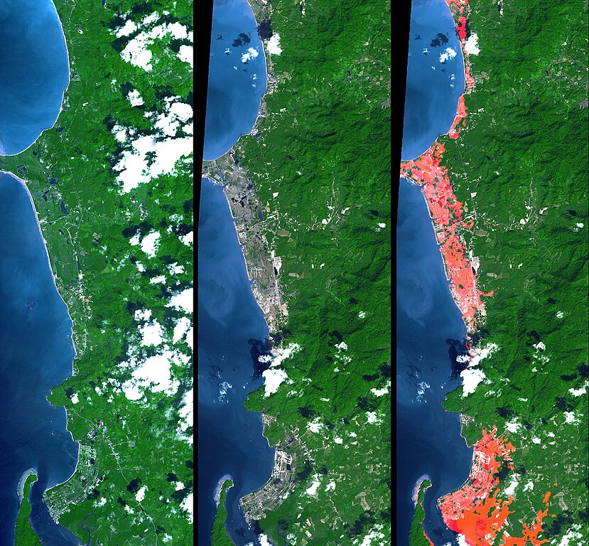
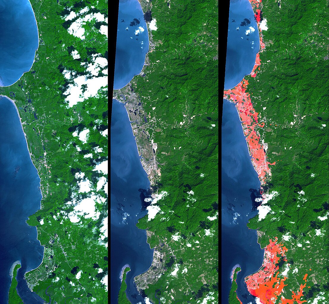
English: Simulated natural color images of a 27 kilometer long stretch of coast north of the Phuket Airport in the Khao Lak, Thailand on December 31 (middle) and two years earlier (left), showing changes to the coast caused by a tsunami. The image on the right is the image in the middle with red highlights of the changes. Additional details can be found at the source link. |
| Ημερομηνία | November 15, 2002 and December 31, 2004 (ASTER), February 2000 (SRTM). See the source link for information about the individual photos |
| Πηγή | NASA Photojournal - http://photojournal.jpl.nasa.gov/catalog/PIA06671 |
| Δημιουργός |
ASTER: NASA/GSFC/METI/ERSDAC/JAROS, and U.S./Japan ASTER Science Team |
Αδειοδότηση
| Αυτό το αρχείο είναι κοινό κτήμα γιατί δημιουργήθηκε από την NASA. Η πολιτική πνευματικής ιδιοκτησίας της NASA δηλώνει ότι «Το υλικό της NASA δεν προστατεύεται από copyright εκτός αν αναφέρεται». (Σελίδα με την πολιτική πνευματικής ιδιοκτησίας της NASA ή Πολιτική Χρήσης Εικόνων του JPL). | ||
 |
Προσοχή:
|
Καταγραφές ανεβασμάτων πρωτότυπου αρχείου
The original description page was here. All following user names refer to en.wikipedia.
- 2005-04-16 17:22 SeanMack 1987×1840× (737390 bytes) PIA06671: Tsunami Inundation, North of Phuket, Thailand ASTER Images and SRTM Elevation Model NASA
Ιστορικό αρχείου
Κλικάρετε σε μια ημερομηνία/ώρα για να δείτε το αρχείο όπως εμφανιζόταν εκείνη τη στιγμή.
| Ώρα/Ημερομ. | Μικρογραφία | Διαστάσεις | Χρήστης | Σχόλια | |
|---|---|---|---|---|---|
| τελευταία | 01:43, 2 Ιανουαρίου 2012 | | 1.987 × 1.840 (720 KB) | File Upload Bot (Magnus Manske) | {{BotMoveToCommons|en.wikipedia|year={{subst:CURRENTYEAR}}|month={{subst:CURRENTMONTHNAME}}|day={{subst:CURRENTDAY}}}} {{Information |Description={{en|PIA06671: Tsunami Inundation, North of Phuket, Thailand ASTER Images and SRTM Elevation Model Source: |
Συνδέσεις αρχείου
Τα παρακάτω λήμματα συνδέουν σε αυτό το αρχείο:
Καθολική χρήση αρχείου
Τα ακόλουθα άλλα wiki χρησιμοποιούν αυτό το αρχείο:
- Χρήση σε de.wikipedia.org
- Χρήση σε en.wikipedia.org
- Χρήση σε eo.wikipedia.org
- Χρήση σε ko.wikipedia.org
- Χρήση σε ms.wikipedia.org
- Χρήση σε my.wikipedia.org
- Χρήση σε pt.wikipedia.org
- Χρήση σε tr.wikipedia.org
- Χρήση σε www.wikidata.org