Αρχείο:Us historic territories.jpg

Μέγεθος αυτής της προεπισκόπησης: 800 × 542 εικονοστοιχεία . Άλλες αναλύσεις: 320 × 217 εικονοστοιχεία | 640 × 434 εικονοστοιχεία | 1.024 × 694 εικονοστοιχεία | 1.280 × 868 εικονοστοιχεία | 1.550 × 1.051 εικονοστοιχεία.
Εικόνα σε υψηλότερη ανάλυση (1.550 × 1.051 εικονοστοιχεία, μέγεθος αρχείου: 1,24 MB, τύπος MIME: image/jpeg)
|
|
Αυτό το αρχείο και η περιγραφή του προέρχονται από το Wikimedia Commons. Οι πληροφορίες από την σελίδα περιγραφής του εκεί εμφανίζονται παρακάτω. |
Σύνοψη
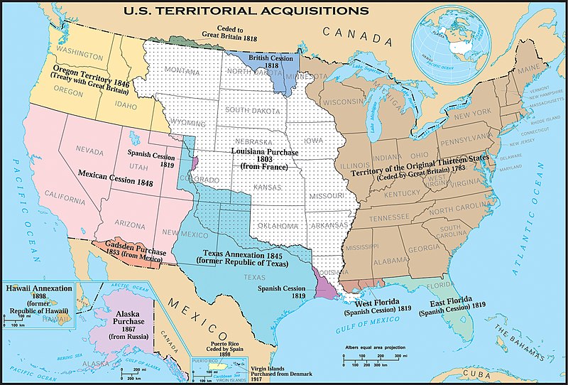
| Περιγραφή | United States historic territory acquisitions. Thirteen Colonies, Louisiana Purchase, British and Spanish Cession, ect. This map uses incorrect terms in that Great Britain didn't exist as a political entity in 1818 or 1846, having been superseded by the United Kingdom following the Act of Union with Ireland in 1801. |
| Ημερομηνία | |
| Πηγή | |
| Δημιουργός | Hewstep 20:08, 1 April 2006 (UTC) |
Αδειοδότηση
This map was obtained from an edition of the National Atlas of the United States. Like almost all works of the U.S. federal government, works from the National Atlas are in the public domain in the United States.
Online access: NationalAtlas.gov | 1970 print edition: Library of Congress, Perry-Castañeda Library
|
Ιστορικό αρχείου
Κλικάρετε σε μια ημερομηνία/ώρα για να δείτε το αρχείο όπως εμφανιζόταν εκείνη τη στιγμή.
| Ώρα/Ημερομ. | Μικρογραφία | Διαστάσεις | Χρήστης | Σχόλια | |
|---|---|---|---|---|---|
| τελευταία | 07:29, 19 Φεβρουαρίου 2006 | | 1.550 × 1.051 (1,24 MB) | Aude | United States historic territory acquisitions Source: [http://www.nationalatlas.gov/ USGS National Atlas] Text labels modified (increased size), cropped, and converted to svg format by User:Kmf164 |
Συνδέσεις αρχείου
Τα παρακάτω λήμματα συνδέουν σε αυτό το αρχείο:
Καθολική χρήση αρχείου
Τα ακόλουθα άλλα wiki χρησιμοποιούν αυτό το αρχείο:
- Χρήση σε en.wikipedia.org
- Χρήση σε eo.wikipedia.org
- Χρήση σε mwl.wikipedia.org
- Χρήση σε pt.wikipedia.org
- Χρήση σε sl.wikipedia.org