Αρχείο:Brandenburg 1688 and 1320.jpg

Μέγεθος αυτής της προεπισκόπησης: 721 × 600 εικονοστοιχεία . Άλλες αναλύσεις: 289 × 240 εικονοστοιχεία | 577 × 480 εικονοστοιχεία | 923 × 768 εικονοστοιχεία | 1.231 × 1.024 εικονοστοιχεία | 1.468 × 1.221 εικονοστοιχεία.
Εικόνα σε υψηλότερη ανάλυση (1.468 × 1.221 εικονοστοιχεία, μέγεθος αρχείου: 2,16 MB, τύπος MIME: image/jpeg)
|
|
Αυτό το αρχείο και η περιγραφή του προέρχονται από το Wikimedia Commons. Οι πληροφορίες από την σελίδα περιγραφής του εκεί εμφανίζονται παρακάτω. |
Σύνοψη
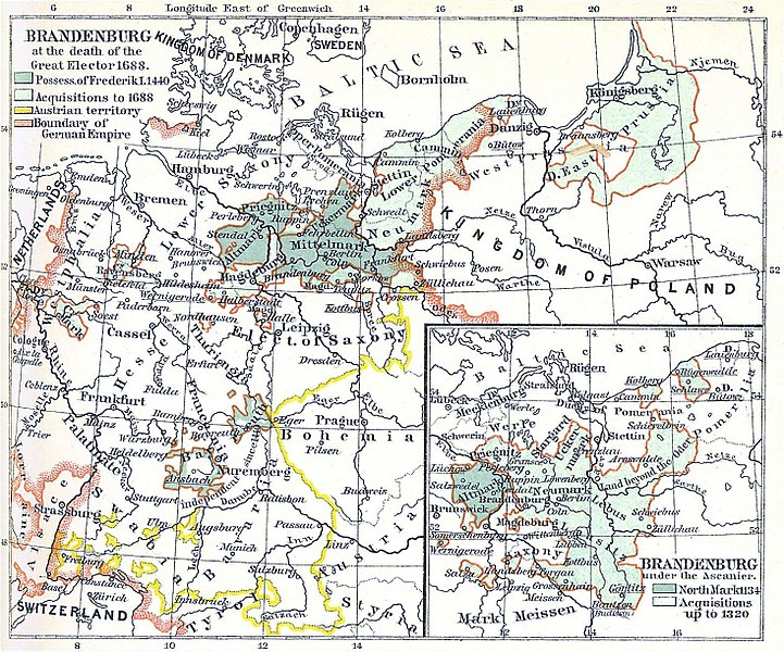
| Περιγραφή | Upper map of two about The Development of Brandenburg to a Prussian Power |
| Ημερομηνία | |
| Πηγή | H.F. Helmolt, History of the World, Volume VII, Dodd Mead 1902. Plate between pages 472 and 473. Scanned at 300 dpi. Dates shown are 1688, 1320 in inset. 1806 is in the lower map (not shown) |
| Δημιουργός | Credited as London: Wm Heinemann |
| Άδεια (Επαναχρησιμοποίηση αυτού του αρχείου) |
Public Domain |
| άλλες εκδόσεις | Image:The Development of Brandenburg to a Prussian Power.jpg is the full image. Image:Brandenburg 1806.jpg is the lower half. |
Αδειοδότηση
This media file is in the public domain in the United States. This applies to U.S. works where the copyright has expired, often because its first publication occurred prior to January 1, 1929, and if not then due to lack of notice or renewal. See this page for further explanation.
|
 | |
 |
This image might not be in the public domain outside of the United States; this especially applies in the countries and areas that do not apply the rule of the shorter term for US works, such as Canada, Mainland China (not Hong Kong or Macao), Germany, Mexico, and Switzerland. The creator and year of publication are essential information and must be provided. See Wikipedia:Public domain and Wikipedia:Copyrights for more details.
|
Ιστορικό αρχείου
Κλικάρετε σε μια ημερομηνία/ώρα για να δείτε το αρχείο όπως εμφανιζόταν εκείνη τη στιγμή.
| Ώρα/Ημερομ. | Μικρογραφία | Διαστάσεις | Χρήστης | Σχόλια | |
|---|---|---|---|---|---|
| τελευταία | 22:30, 12 Ιανουαρίου 2018 | | 1.468 × 1.221 (2,16 MB) | Alphathon | Redid colour correction and cropping from original version |
| 09:09, 25 Νοεμβρίου 2008 |  | 1.463 × 1.214 (1,81 MB) | Gothika | light corr. | |
| 17:56, 5 Οκτωβρίου 2007 |  | 1.480 × 1.237 (957 KB) | Jmabel | ==Summary== {{Information |Description=Upper map of two about The Development of Brandenburg to a Prussian Power |Source=H.F. Helmolt, ''History of the World'', Volume VII, Dodd Mead 1902. Plate between pages 472 and 473. Scanned at 300 dpi. Dates shown a |
Συνδέσεις αρχείου
Τα παρακάτω λήμματα συνδέουν σε αυτό το αρχείο:
Καθολική χρήση αρχείου
Τα ακόλουθα άλλα wiki χρησιμοποιούν αυτό το αρχείο:
- Χρήση σε ar.wikipedia.org
- Χρήση σε azb.wikipedia.org
- Χρήση σε bg.wikipedia.org
- Χρήση σε en.wikipedia.org
- Χρήση σε es.wikipedia.org
- Χρήση σε et.wikipedia.org
- Χρήση σε fa.wikipedia.org
- Χρήση σε he.wikipedia.org
- Χρήση σε it.wikipedia.org
- Χρήση σε nl.wikipedia.org
- Χρήση σε nn.wikipedia.org
- Χρήση σε ru.wikipedia.org
- Χρήση σε sv.wikipedia.org
- Χρήση σε th.wikipedia.org
- Χρήση σε vi.wikipedia.org
- Χρήση σε www.wikidata.org