Αρχείο:Brittain 410.jpg
Εικόνα σε υψηλότερη ανάλυση (1.111 × 1.497 εικονοστοιχεία, μέγεθος αρχείου: 369 KB, τύπος MIME: image/jpeg)
|
|
Αυτό το αρχείο και η περιγραφή του προέρχονται από το Wikimedia Commons. Οι πληροφορίες από την σελίδα περιγραφής του εκεί εμφανίζονται παρακάτω. |
Σύνοψη
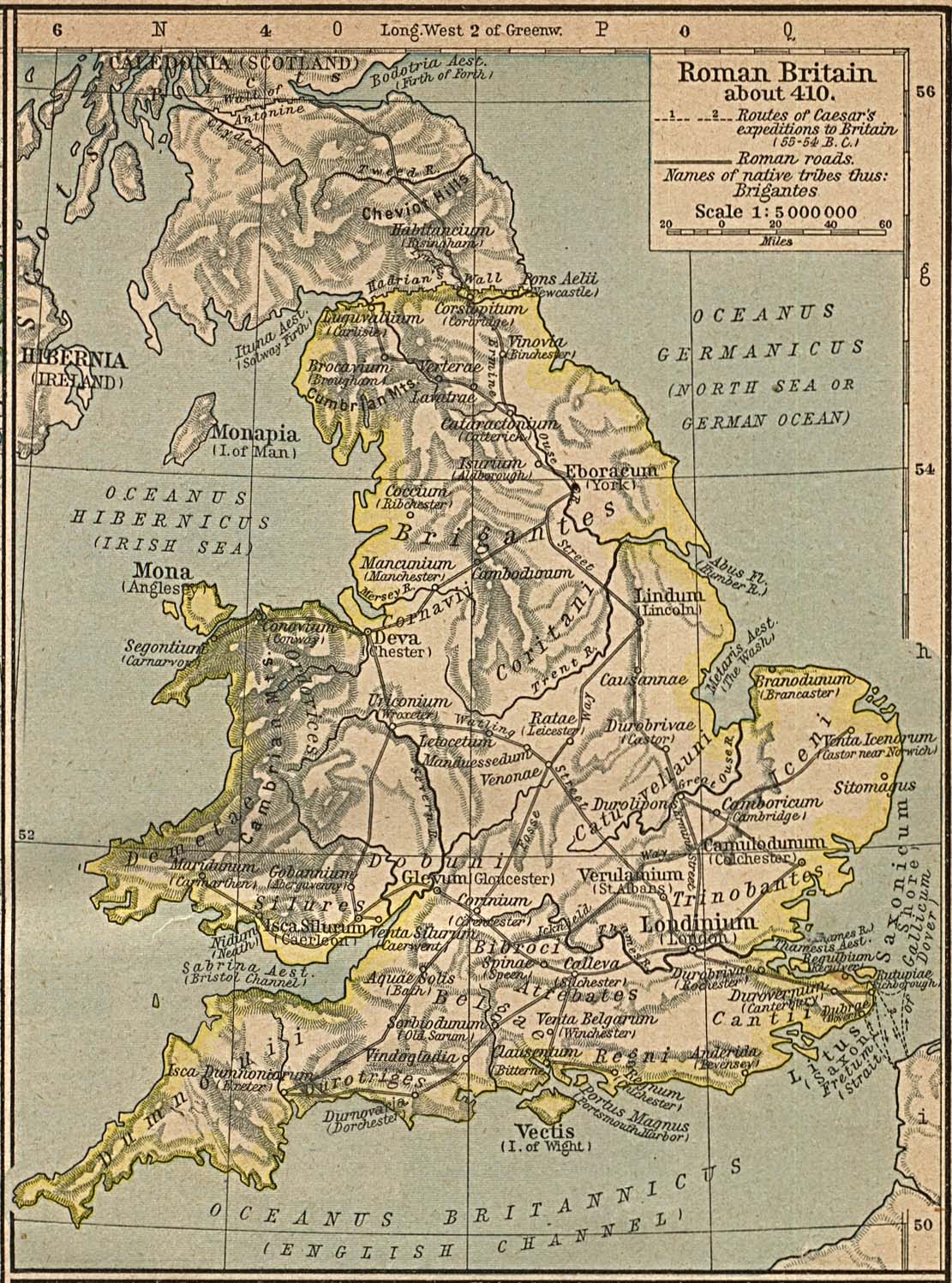
Map of the isle Great Britain in the year 410. Image comes from the Historical Maps of Europe at University of Texas at Austin The work is from From The Historical Atlas by William R. Shepherd, 1926.
Map is released into the public Domain.
Αδειοδότηση
|
Αυτό το έργο είναι κοινό κτήμα στη χώρα προέλευσής του και άλλες χώρες και περιοχές όπου η διάρκεια πνευματικών δικαιωμάτων είναι όσο η ζωή του δημιουργού και μέχρι 70 χρόνια μετά ή λιγότερο.
| |
| Αυτό το αρχείο έχει χαρακτηριστεί ως απαλλαγμένο από γνωστούς περιορισμούς βάσει της νομοθεσίας περί πνευματικής ιδιοκτησίας, περιλαμβανομένων όλων των συναφών και συγγενικών δικαιωμάτων. | |
Ιστορικό αρχείου
Κλικάρετε σε μια ημερομηνία/ώρα για να δείτε το αρχείο όπως εμφανιζόταν εκείνη τη στιγμή.
| Ώρα/Ημερομ. | Μικρογραφία | Διαστάσεις | Χρήστης | Σχόλια | |
|---|---|---|---|---|---|
| τελευταία | 15:24, 3 Δεκεμβρίου 2005 | | 1.111 × 1.497 (369 KB) | Migdejong | Map of the isle Great Brittain in the year 410. Image comes from the University of Texas at Austin: http://geography.about.com/gi/dynamic/offsite.htm?site=http://www.lib.utexas.edu/maps/historical/history%5Feurope.html Map is released into the publi |
Συνδέσεις αρχείου
Τα παρακάτω λήμματα συνδέουν σε αυτό το αρχείο:
Καθολική χρήση αρχείου
Τα ακόλουθα άλλα wiki χρησιμοποιούν αυτό το αρχείο:
- Χρήση σε ar.wikipedia.org
- Χρήση σε arz.wikipedia.org
- Χρήση σε azb.wikipedia.org
- Χρήση σε bn.wikipedia.org
- Χρήση σε br.wikipedia.org
- Χρήση σε ca.wikipedia.org
- Χρήση σε cy.wikipedia.org
- Χρήση σε en.wikipedia.org
- Χρήση σε es.wikipedia.org
- Χρήση σε et.wikipedia.org
- Χρήση σε fr.wikipedia.org
- Χρήση σε hr.wikipedia.org
- Χρήση σε hu.wikipedia.org
- Χρήση σε hy.wikipedia.org
- Χρήση σε is.wikipedia.org
- Χρήση σε it.wikipedia.org
- Χρήση σε lt.wikipedia.org
- Χρήση σε pl.wikipedia.org
- Χρήση σε ru.wikipedia.org
- Χρήση σε sh.wikipedia.org
- Χρήση σε sl.wikipedia.org
- Χρήση σε sr.wikipedia.org
- Χρήση σε zh.wikipedia.org