Αρχείο:De facto cantons of Rojava.png

Μέγεθος αυτής της προεπισκόπησης: 725 × 599 εικονοστοιχεία . Άλλες αναλύσεις: 290 × 240 εικονοστοιχεία | 581 × 480 εικονοστοιχεία | 929 × 768 εικονοστοιχεία | 1.239 × 1.024 εικονοστοιχεία | 2.000 × 1.653 εικονοστοιχεία.
Εικόνα σε υψηλότερη ανάλυση (2.000 × 1.653 εικονοστοιχεία, μέγεθος αρχείου: 268 KB, τύπος MIME: image/png)
|
|
Αυτό το αρχείο και η περιγραφή του προέρχονται από το Wikimedia Commons. Οι πληροφορίες από την σελίδα περιγραφής του εκεί εμφανίζονται παρακάτω. |

|
This map image could be re-created using vector graphics as an SVG file. This has several advantages; see Commons:Media for cleanup for more information. If an SVG form of this image is available, please upload it and afterwards replace this template with
{{vector version available|new image name}}.
It is recommended to name the SVG file “De facto cantons of Rojava.svg”—then the template Vector version available (or Vva) does not need the new image name parameter. |
Σύνοψη
| Περιγραφή |
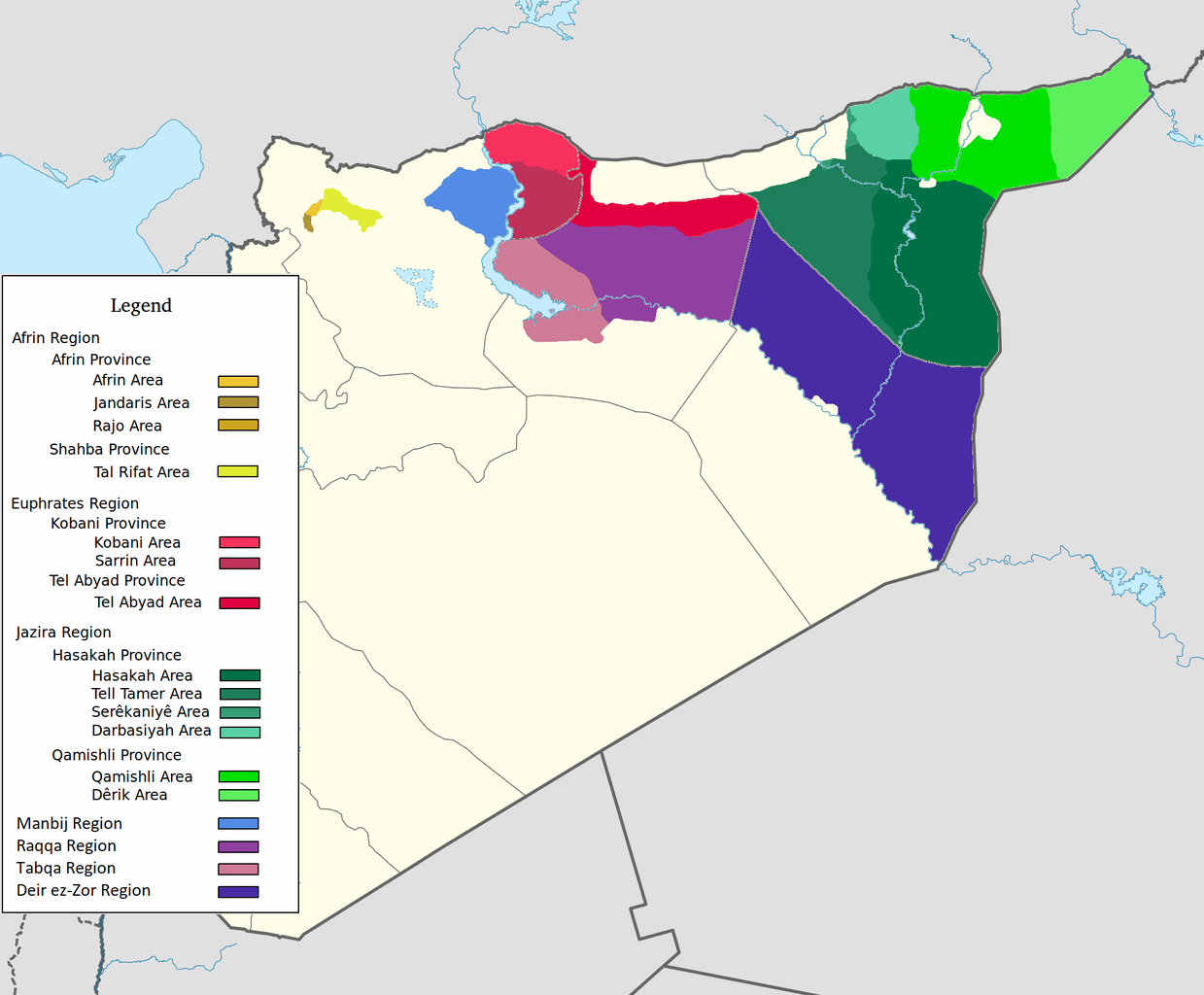
العربية: اقليم عفرين اقليم الفرات اقليم الجزيرة English: Afrin Region Euphrates Region Jazeera Region No region 한국어: 아프린 주 유프라테스 주 자제라 주 없음 |
| Ημερομηνία | |
| Πηγή | Έργο αυτού που το ανεβάζει |
| Δημιουργός | Editor abcdef |
| άλλες εκδόσεις |
This image includes elements that have been taken or adapted from this file:  |
Αδειοδότηση
Εγώ, ο κάτοχος των πνευματικών δικαιωμάτων αυτού του έργου, το δημοσιεύω δια του παρόντος υπό την εξής άδεια χρήσης:
Το αρχείο διανέμεται υπό την άδεια Creative Commons Αναφορά προέλευσης-Παρόμοια διανομή 3.0 Μη εισαγόμενη
- Είστε ελεύθερος:
- να μοιραστείτε – να αντιγράψετε, διανέμετε και να μεταδώσετε το έργο
- να διασκευάσετε – να τροποποιήσετε το έργο
- Υπό τις ακόλουθες προϋποθέσεις:
- αναφορά προέλευσης – Θα πρέπει να κάνετε κατάλληλη αναφορά, να παρέχετε σύνδεσμο για την άδεια και να επισημάνετε εάν έγιναν αλλαγές. Μπορείτε να το κάνετε με οποιοδήποτε αιτιολογήσιμο λόγο, χωρίς όμως να εννοείται με οποιονδήποτε τρόπο ότι εγκρίνουν εσάς ή τη χρήση του έργου από εσάς.
- παρόμοια διανομή – Εάν αλλάξετε, τροποποιήσετε ή δημιουργήσετε πάνω στο έργο αυτό, μπορείτε να διανείμετε αυτό που θα προκύψει μόνο υπό τους όρους της ίδιας ή συμβατής άδειας με το πρωτότυπο.
Ιστορικό αρχείου
Κλικάρετε σε μια ημερομηνία/ώρα για να δείτε το αρχείο όπως εμφανιζόταν εκείνη τη στιγμή.
| Ώρα/Ημερομ. | Μικρογραφία | Διαστάσεις | Χρήστης | Σχόλια | |
|---|---|---|---|---|---|
| τελευταία | 08:29, 27 Μαΐου 2020 | | 2.000 × 1.653 (268 KB) | AntonSamuel | Reverted to version as of 09:02, 8 April 2020 (UTC) Restoring original map without stripes per COM:OW and discussion on the Rojava talk page on Wikipedia |
| 09:05, 8 Απριλίου 2020 |  | 2.000 × 1.653 (224 KB) | Bill497 | Reverted to version as of 08:59, 8 April 2020 (UTC) Revert vandalism. | |
| 09:02, 8 Απριλίου 2020 |  | 2.000 × 1.653 (268 KB) | AntonSamuel | Reverted to version as of 08:51, 8 April 2020 (UTC) Third, and last warning given on user talk page. | |
| 08:59, 8 Απριλίου 2020 |  | 2.000 × 1.653 (224 KB) | Bill497 | Reverted to version as of 08:11, 8 April 2020 (UTC) Revert vandalism for a 3rd time. User is reverting a referenced map to an unreferenced version. | |
| 08:51, 8 Απριλίου 2020 |  | 2.000 × 1.653 (268 KB) | AntonSamuel | Reverted to version as of 17:57, 7 April 2020 (UTC) Once again, use the Rojava talk page to discuss before making reverts and don't throw around unfounded vandalism claims. Second warning on talk page given. | |
| 08:11, 8 Απριλίου 2020 |  | 2.000 × 1.653 (224 KB) | Bill497 | Reverted to version as of 11:10, 7 April 2020 (UTC) Revert vandalism. | |
| 17:57, 7 Απριλίου 2020 |  | 2.000 × 1.653 (268 KB) | AntonSamuel | Reverted to version as of 00:50, 7 April 2020 (UTC) Restoring viewable version - Use Rojava talk page, warning left on user talk page | |
| 11:10, 7 Απριλίου 2020 |  | 2.000 × 1.653 (224 KB) | Bill497 | Reverted to version as of 12:33, 2 April 2020 (UTC) Revert attempted vandalism into a factually incorrect version of the map. SDF has entirely no presence in some of the dashed zones. Due to fog of war these areas are all displaced as mixed with government control. Russia is the only reliable source displaying where the government is present. | |
| 00:50, 7 Απριλίου 2020 |  | 2.000 × 1.653 (268 KB) | AntonSamuel | Continuation from below: ...manner. Further sources are needed apart from the Russian military maps - they cannot be considered to be neutral or factually accurate without additional verification. | |
| 00:46, 7 Απριλίου 2020 |  | 2.000 × 1.653 (218 KB) | AntonSamuel | Clearing the 50/50 paint because of the visual difficulty and for deviation from the main purpose of this map - which is to display the various subregions of the civilian administration of the de facto autonomous region, not military control agreements such as SDF-SAA/Russia and SDF-US/US-led coalition which have no known civilian aspect as of date. Please discuss the issue first and foremost on the Rojava talk page if areas with an SAA/Russian or a US presence need to be highlighted in some... |
Συνδέσεις αρχείου
Δεν υπάρχουν σελίδες που συνδέουν σε αυτό το αρχείο.
Καθολική χρήση αρχείου
Τα ακόλουθα άλλα wiki χρησιμοποιούν αυτό το αρχείο:
- Χρήση σε ar.wikipedia.org
- Χρήση σε arz.wikipedia.org
- Χρήση σε azb.wikipedia.org
- Χρήση σε ca.wikipedia.org
- Χρήση σε diq.wikipedia.org
- Χρήση σε fa.wikipedia.org
- Χρήση σε glk.wikipedia.org
- Χρήση σε id.wikipedia.org
- Χρήση σε ku.wikipedia.org
- Χρήση σε nl.wikipedia.org
- Χρήση σε ru.wikipedia.org
- Χρήση σε tr.wikipedia.org
- Χρήση σε vi.wikipedia.org
- Χρήση σε www.wikidata.org
- Χρήση σε zh.wikipedia.org