Αρχείο:Hitler-Headquarters-Europe.png

Εικόνα σε υψηλότερη ανάλυση (1.120 × 790 εικονοστοιχεία, μέγεθος αρχείου: 473 KB, τύπος MIME: image/png)
|
|
Αυτό το αρχείο και η περιγραφή του προέρχονται από το Wikimedia Commons. Οι πληροφορίες από την σελίδα περιγραφής του εκεί εμφανίζονται παρακάτω. |
Σύνοψη
| Περιγραφή |
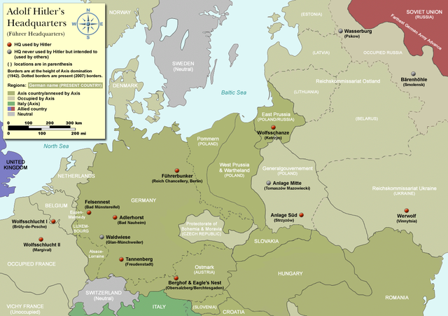
Map of Adolf Hitler's Headquarters (Führer Headquarters) in Europe 1933-1945. Countries that were part of the Axis/annexed by Axis are colored dark green (Germany, Austria, Hungary, Romania & Italy etc). |
| Ημερομηνία | |
| Πηγή | Self-made, based on information from references below |
| Δημιουργός | User:Dna-Dennis |
| Άδεια (Επαναχρησιμοποίηση αυτού του αρχείου) |
CC, see below. The map is completely unrestricted for any Wikipedia/Wikimedia project. If you have any opinions/suggestions, please contact me here on my talk page. |
| άλλες εκδόσεις |
|


.png)

|
This historical map image could be re-created using vector graphics as an SVG file. This has several advantages; see Commons:Media for cleanup for more information. If an SVG form of this image is available, please upload it and afterwards replace this template with
{{vector version available|new image name}}.
It is recommended to name the SVG file “Hitler-Headquarters-Europe.svg”—then the template Vector version available (or Vva) does not need the new image name parameter. |
Αδειοδότηση
- Είστε ελεύθερος:
- να μοιραστείτε – να αντιγράψετε, διανέμετε και να μεταδώσετε το έργο
- να διασκευάσετε – να τροποποιήσετε το έργο
- Υπό τις ακόλουθες προϋποθέσεις:
- αναφορά προέλευσης – Θα πρέπει να κάνετε κατάλληλη αναφορά, να παρέχετε σύνδεσμο για την άδεια και να επισημάνετε εάν έγιναν αλλαγές. Μπορείτε να το κάνετε με οποιοδήποτε αιτιολογήσιμο λόγο, χωρίς όμως να εννοείται με οποιονδήποτε τρόπο ότι εγκρίνουν εσάς ή τη χρήση του έργου από εσάς.
References
- Beevor, Antony, Berlin - The Downfall 1945
- Eberle, Henrik and Uhl, Matthias, The Unknown Hitler
- Hansen, Hans-Josef: Felsennest - Das vergessene Führerhauptquartier in der Eifel. Bau, Nutzung, Zerstörung. Aachen 2006, Helios-Verlag, ISBN 3-938208-21-X.
- Kuffner, Alexander: Zeitreiseführer Eifel 1933-45. Helios, Aachen 2007, ISBN 978-3-938208-42-7.
- Raiber, Richard, Guide to Hitler's Headquarters, After the Battle archive copy at the Wayback Machine, No.19, Special Edition, Battle of Britain International Ltd, 1977, London
- Ramsey, Winston G. (editor) & Posch, Tom (researcher), The Berlin Führerbunker: The Thirteenth Hole, After the Battle archive copy at the Wayback Machine, No.61, Special Edition, Battle of Britain International Ltd, 1988, London
- von Loringhoven, Bernd Freytag/d’Alançon, François: Mit Hitler im Bunker. Aufzeichnungen aus dem Führerhauptquartier Juli 1944 – April 1945. Berlin 2005, wjs-Verlag, ISBN 3-937989-14-5.
- Schulz, Alfons: Drei Jahre in der Nachrichtenzentrale des Führerhauptquartiers. Christiana-Verlag, Stein am Rhein. 2. Aufl. 1997. ISBN 3-7171-1028-4.
- Seidler, Franz W./Zeigert, Dieter : Die Führerhauptquartiere. Anlagen und Planungen im Zweiten Weltkrieg. München: Herbig 2000. ISBN 3-7766-2154-0.
Notes on the individual headquarters
- Adlerhorst (Guide to Hitler's Headquarters, p.51)
- Anlage Mitte (Guide to Hitler's Headquarters, p.48)
- Anlage Süd (Guide to Hitler's Headquarters, p.48)
- Berghof/Eagle's nest (Guide to Hitler's Headquarters, p.2) - please note that the "Eagle's nest" was rarely used
- Bärenhöhle (www.bundesarchiv.de)
- Felsennest (Guide to Hitler's Headquarters, p.4)
- Führerbunker (After The Battle, No.61 (entire))
- Tannenberg (Guide to Hitler's Headquarters, p.18)
- Waldwiese (www.bundesarchiv.de)
- Wasserburg (www.bundesarchiv.de)
- Werwolf (Guide to Hitler's Headquarters, p.48)
- Wolfsschanze (Guide to Hitler's Headquarters, p.28)
- Wolfsschlucht I (Guide to Hitler's Headquarters, p.10)
- Wolfsschlucht II (Guide to Hitler's Headquarters, p.49)
Ιστορικό αρχείου
Κλικάρετε σε μια ημερομηνία/ώρα για να δείτε το αρχείο όπως εμφανιζόταν εκείνη τη στιγμή.
| Ώρα/Ημερομ. | Μικρογραφία | Διαστάσεις | Χρήστης | Σχόλια | |
|---|---|---|---|---|---|
| τελευταία | 08:19, 3 Απριλίου 2012 | | 1.120 × 790 (473 KB) | Asav | Wehrwolf -> Werwolf (Correct name, see "Naming" section on en.wp) |
| 03:54, 20 Δεκεμβρίου 2007 |  | 1.120 × 790 (537 KB) | Dna-webmaster~commonswiki | completely new version with 1942 borders | |
| 23:32, 16 Δεκεμβρίου 2007 |  | 1.120 × 790 (408 KB) | Dna-webmaster~commonswiki | updated map - please suggest changes before making any bold moves, please | |
| 17:25, 10 Δεκεμβρίου 2007 |  | 1.096 × 704 (37 KB) | Matthead | Modified version, file size reduced, country coloring removed (countries as of 2007 were not involved in WW2) | |
| 04:27, 21 Οκτωβρίου 2007 |  | 1.120 × 790 (407 KB) | Dna-webmaster~commonswiki | new version with new colors | |
| 14:11, 16 Οκτωβρίου 2007 |  | 1.120 × 790 (447 KB) | Dna-webmaster~commonswiki | new version | |
| 20:46, 14 Οκτωβρίου 2007 |  | 1.120 × 790 (423 KB) | Dna-webmaster~commonswiki | quick update | |
| 20:38, 14 Οκτωβρίου 2007 |  | 1.120 × 790 (425 KB) | Dna-webmaster~commonswiki | {{Information |Description=Map of Adolf Hitler's Headquarters (Führer Headquarters) in Europe 1933-1945.<br><br> For more detailed information, please see below. |Source=Self-made |Date=October 14, 2007 |Author=[http://en.wikipedia.org/wiki/User:Dna-webm |
Συνδέσεις αρχείου
Τα παρακάτω λήμματα συνδέουν σε αυτό το αρχείο:
Καθολική χρήση αρχείου
Τα ακόλουθα άλλα wiki χρησιμοποιούν αυτό το αρχείο:
- Χρήση σε ar.wikipedia.org
- Χρήση σε ast.wikipedia.org
- Χρήση σε ba.wikipedia.org
- Χρήση σε bg.wikipedia.org
- Χρήση σε ca.wikipedia.org
- Χρήση σε cs.wikipedia.org
- Χρήση σε da.wikipedia.org
- Χρήση σε en.wikipedia.org
- Χρήση σε es.wikipedia.org
- Χρήση σε et.wikipedia.org
- Χρήση σε fi.wikipedia.org
- Χρήση σε fr.wikipedia.org
- Χρήση σε he.wikipedia.org
- Χρήση σε id.wikipedia.org
- Χρήση σε it.wikipedia.org
- Χρήση σε ja.wikipedia.org
- Χρήση σε ko.wikipedia.org
- Χρήση σε ms.wikipedia.org
- Χρήση σε nl.wikipedia.org
- Χρήση σε no.wikipedia.org
- Χρήση σε pl.wikipedia.org
- Χρήση σε pt.wikipedia.org
Δείτε περισσότερη καθολική χρήση αυτού του αρχείου.