Αρχείο:Indonesia 2002 CIA map.jpg
Εικόνα σε υψηλότερη ανάλυση (2.000 × 1.340 εικονοστοιχεία, μέγεθος αρχείου: 1,43 MB, τύπος MIME: image/jpeg)
|
|
Αυτό το αρχείο και η περιγραφή του προέρχονται από το Wikimedia Commons. Οι πληροφορίες από την σελίδα περιγραφής του εκεί εμφανίζονται παρακάτω. |
Σύνοψη
| Περιγραφή |
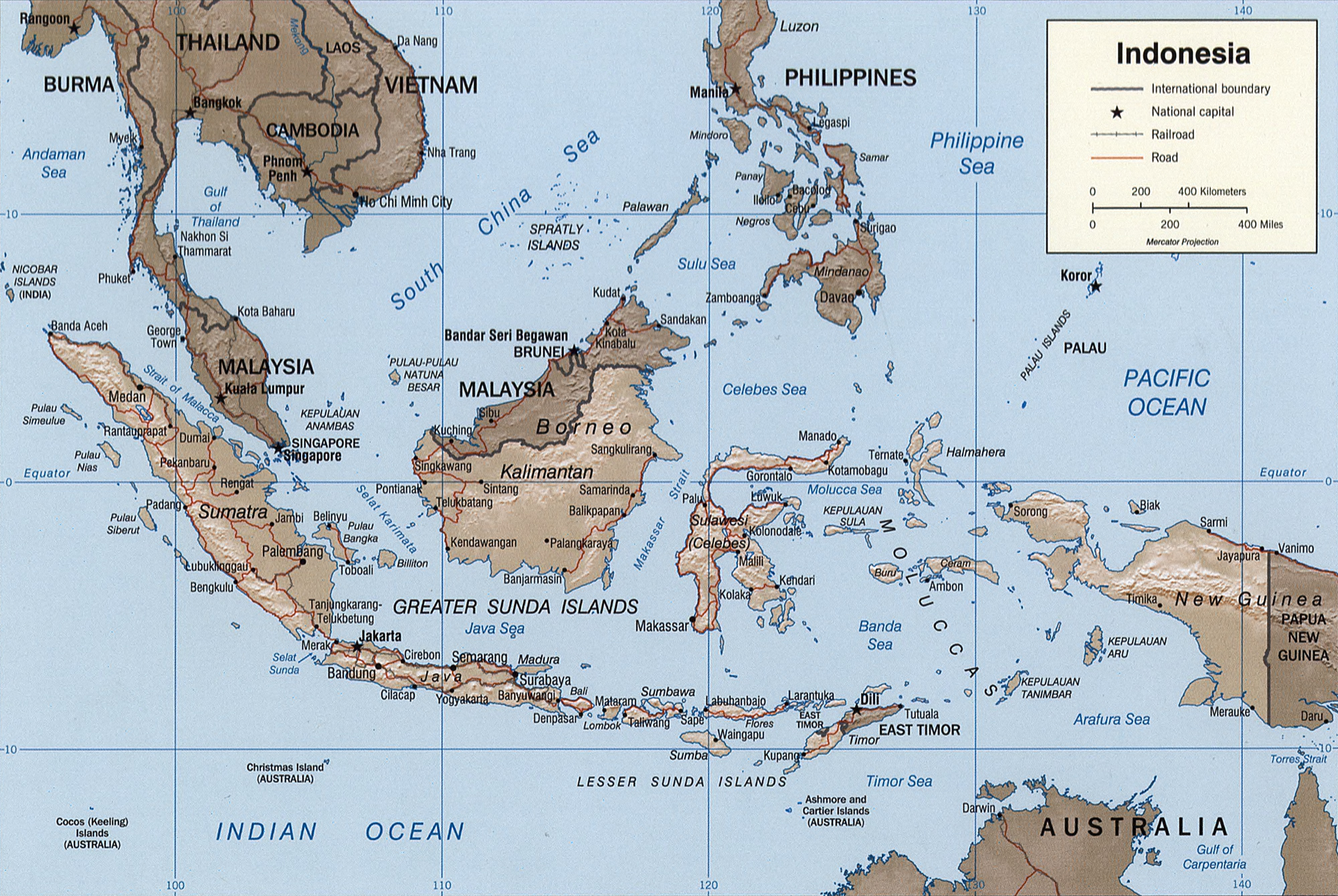
English: Map of Indonesia.
Français : Carte d'Indonésie. |
|||||||||||||||||||||||||
| Ημερομηνία | ||||||||||||||||||||||||||
| Πηγή |
|
|||||||||||||||||||||||||
| Δημιουργός | Central Intelligence Agency, United States of America | |||||||||||||||||||||||||
| άλλες εκδόσεις |
|
|||||||||||||||||||||||||


Αδειοδότηση
| This image is a work of a Central Intelligence Agency employee, taken or made as part of that person's official duties. As a Work of the United States Government, this image or media is in the public domain in the United States.
|

|
Original description
Indonesia.
United States. Central Intelligence Agency.
CREATED/PUBLISHED
[Washington, D.C. : Central Intelligence Agency, 2002]
NOTES
Relief shown by shading.
"Base 802899AI (C00429) 11-02."
Also issued without shaded relief.
Scale [ca. 1:25,000,000] ; Mercator proj. (E 1040--E 1430/N 170--S 150).
SUBJECTS
MEDIUM
1 map : col. ; 16 x 23 cm.
CALL NUMBER
G8070 2002 .U6
REPOSITORY
Library of Congress Geography and Map Division Washington, D.C. 20540-4650 USA
DIGITAL ID
g8070 ct000982 http://hdl.loc.gov/loc.gmd/g8070.ct000982
Ιστορικό αρχείου
Κλικάρετε σε μια ημερομηνία/ώρα για να δείτε το αρχείο όπως εμφανιζόταν εκείνη τη στιγμή.
| Ώρα/Ημερομ. | Μικρογραφία | Διαστάσεις | Χρήστης | Σχόλια | |
|---|---|---|---|---|---|
| τελευταία | 03:39, 26 Οκτωβρίου 2005 | | 2.000 × 1.340 (1,43 MB) | Brian0918 | Indonesia. United States. Central Intelligence Agency. CREATED/PUBLISHED [Washington, D.C. : Central Intelligence Agency, 2002] NOTES Relief shown by shading. "Base 802899AI (C00429) 11-02." Also issued without shaded relief. Scale [ca. 1:25,000,000 |
Συνδέσεις αρχείου
Τα παρακάτω λήμματα συνδέουν σε αυτό το αρχείο:
Καθολική χρήση αρχείου
Τα ακόλουθα άλλα wiki χρησιμοποιούν αυτό το αρχείο:
- Χρήση σε ace.wikipedia.org
- Χρήση σε ar.wikipedia.org
- Χρήση σε azb.wikipedia.org
- Χρήση σε az.wikipedia.org
- Χρήση σε bcl.wikipedia.org
- Χρήση σε bg.wikipedia.org
- Χρήση σε bs.wikipedia.org
- Χρήση σε da.wikipedia.org
- Χρήση σε de.wikipedia.org
- Χρήση σε en.wikipedia.org
- Χρήση σε eo.wikipedia.org
- Χρήση σε es.wikipedia.org
- Χρήση σε eu.wikipedia.org
- Χρήση σε fi.wikipedia.org
- Χρήση σε frr.wikipedia.org
- Χρήση σε fr.wikipedia.org
- Χρήση σε fr.wiktionary.org
- Χρήση σε gl.wikipedia.org
- Χρήση σε he.wikipedia.org
- Χρήση σε hy.wikipedia.org
- Χρήση σε id.wikipedia.org
- Χρήση σε id.wikisource.org
- Χρήση σε is.wikipedia.org
- Χρήση σε ja.wikipedia.org
- Χρήση σε ka.wikipedia.org
- Χρήση σε kk.wikipedia.org
- Χρήση σε mg.wikipedia.org
- Χρήση σε ms.wikipedia.org
- Χρήση σε mt.wikipedia.org
- Χρήση σε nn.wikipedia.org
- Χρήση σε pl.wikipedia.org
- Χρήση σε pl.wiktionary.org
- Χρήση σε pt.wikipedia.org
Δείτε περισσότερη καθολική χρήση αυτού του αρχείου.