Αρχείο:John-Tallis-1851-Tibet-Mongolia-and-Manchuria-33621.jpg

Εικόνα σε υψηλότερη ανάλυση (4.030 × 3.102 εικονοστοιχεία, μέγεθος αρχείου: 12,64 MB, τύπος MIME: image/jpeg)
|
|
Αυτό το αρχείο και η περιγραφή του προέρχονται από το Wikimedia Commons. Οι πληροφορίες από την σελίδα περιγραφής του εκεί εμφανίζονται παρακάτω. |
Σύνοψη
| Περιγραφή |
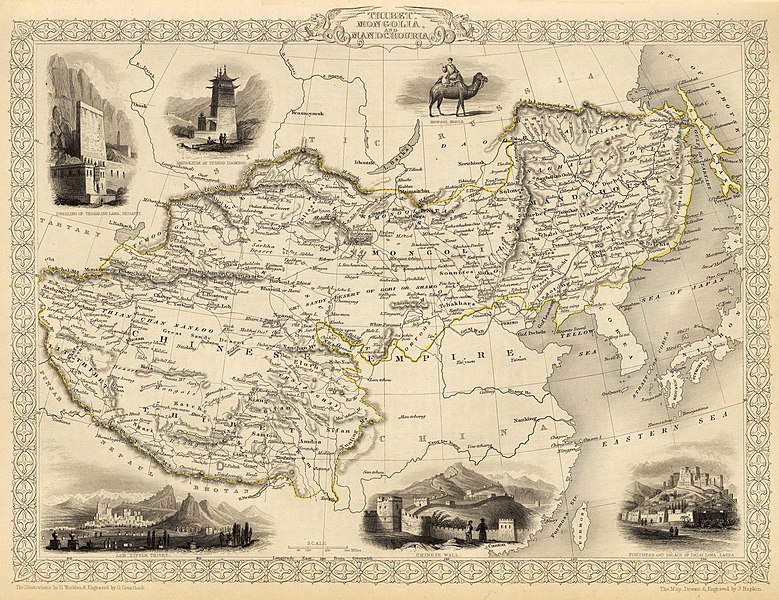
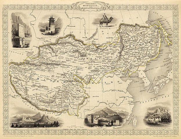
English: Map of the northern and western part of the Chinese Empire - "Thibet, Mongolia, and Mandchouria". The borders are shown as per the 1686 Treaty of Nerchinsk. (They were to be changed drastically in 1858-60, by treaty of Aigun and subsequent agreements). The main Russian center in Transbaikalia is still Nerchinsk, rather than Chita. The outline of Sakhalin Island is already shown fairly correctly, but the body of water separating it from the mainland is still labeled "Gulf of Tartary" (rather than '"Strait).
Français : Carte des parties Nord et Ouest de l'Empire chinois — « Thibet, Mongolie and Mandchourie ». Les frontières sont montrées telles qu'elles étaient définies par le Traité de Nerchinsk de 1686. (Elles allaient être grandement changées en 1858-1860 par le traité d'Aigun et les accords suivants). Le principal centre russe en Transbaïkalie est encore Nerchinsk, plutôt que Chita. Le contour de l'île Sakhaline est déjà décrit très correctement, mais l'étendue d'eau la séparant du continent est encore qualifiée de « golfe de Tartarie » (plutôt que « détroit »).
中文:中国皇国,北部和西部。 |
| Ημερομηνία | |
| Πηγή | John Tallis' atlas of the world. Reproduced at http://www.davidrumsey.com/luna/servlet/detail/RUMSEY~8~1~821~60126:Thibet,-Mongolia,-and-Mandchouria-- (the last version uploaded is from there), http://www.jpmaps.co.uk/mapimages/originals/33621.jpg , and elsewhere |
| Δημιουργός | Martin, R.M.; Tallis, J. & F. The staff of John Tallis: The Illustrations by H. Winkles & Engraved by G. Greatbach. The Map Drawn & Engraved by J. Rapkin. |
| άλλες εκδόσεις | Derivative works of this file: John-Tallis-1851-Tibet-Mongolia-and-Manchuria-NE.jpg |
Αδειοδότηση
|
Αυτό το έργο είναι κοινό κτήμα στη χώρα προέλευσής του και άλλες χώρες και περιοχές όπου η διάρκεια πνευματικών δικαιωμάτων είναι όσο η ζωή του δημιουργού και μέχρι 70 χρόνια μετά ή λιγότερο.
| |
| Αυτό το αρχείο έχει χαρακτηριστεί ως απαλλαγμένο από γνωστούς περιορισμούς βάσει της νομοθεσίας περί πνευματικής ιδιοκτησίας, περιλαμβανομένων όλων των συναφών και συγγενικών δικαιωμάτων. | |
Ιστορικό αρχείου
Κλικάρετε σε μια ημερομηνία/ώρα για να δείτε το αρχείο όπως εμφανιζόταν εκείνη τη στιγμή.
| Ώρα/Ημερομ. | Μικρογραφία | Διαστάσεις | Χρήστης | Σχόλια | |
|---|---|---|---|---|---|
| τελευταία | 20:51, 28 Φεβρουαρίου 2016 | | 4.030 × 3.102 (12,64 MB) | Centpacrr | Crop |
| 02:26, 7 Δεκεμβρίου 2009 |  | 4.700 × 3.750 (4,07 MB) | Vmenkov | better resolution, as available from http://www.davidrumsey.com/luna/servlet/detail/RUMSEY~8~1~821~60126:Thibet,-Mongolia,-and-Mandchouria-- | |
| 01:38, 7 Δεκεμβρίου 2009 |  | 1.289 × 989 (386 KB) | Vmenkov | {{Information |Description={{en|1=Map of the northern and western part of the Chinese Empire - "Thibet, Mongolia, and Mandchouria". The borders are shows as per the 1858 treaty of Aigun. The main Russian center in Transbaikalia is still Nerchinsk, rather |
Συνδέσεις αρχείου
Τα παρακάτω λήμματα συνδέουν σε αυτό το αρχείο:
Καθολική χρήση αρχείου
Τα ακόλουθα άλλα wiki χρησιμοποιούν αυτό το αρχείο:
- Χρήση σε ar.wikipedia.org
- Χρήση σε en.wikipedia.org
- Χρήση σε fr.wikipedia.org
- Χρήση σε hr.wikipedia.org
- Χρήση σε ko.wikipedia.org
- Χρήση σε mn.wikipedia.org
- Χρήση σε sh.wikipedia.org
- Χρήση σε vi.wikipedia.org