Αρχείο:Krt 1510 full.jpg

Εικόνα σε υψηλότερη ανάλυση (4.000 × 3.000 εικονοστοιχεία, μέγεθος αρχείου: 14,13 MB, τύπος MIME: image/jpeg)
|
|
Αυτό το αρχείο και η περιγραφή του προέρχονται από το Wikimedia Commons. Οι πληροφορίες από την σελίδα περιγραφής του εκεί εμφανίζονται παρακάτω. |
Σύνοψη
| Περιγραφή |
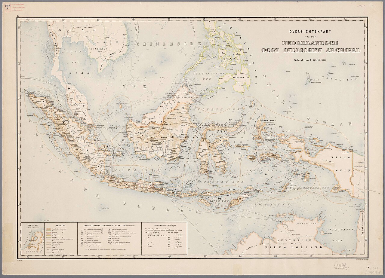
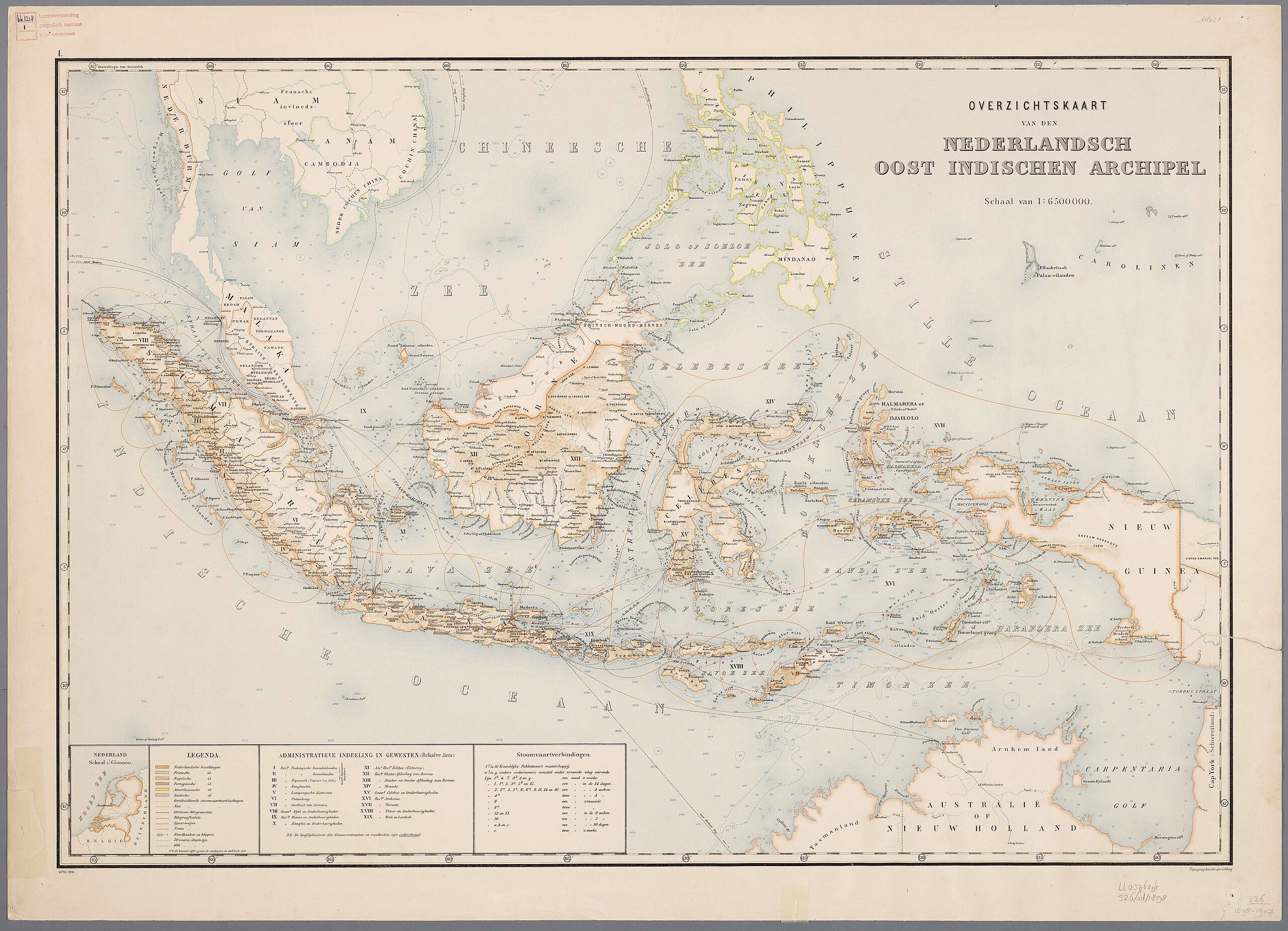
Nederlands: Atlas van Nederlandsch Oost-Indië / samengest. door Topographisch Bureau te Batavia van 1897-1904 |
| Ημερομηνία | 1897-1904 |
| Πηγή |
https://vu.contentdm.oclc.org/digital/collection/krt/id/1510 or https://digitalcollections.universiteitleiden.nl/view/item/2014658 restored and enchanced by u/helloVizart |
| Δημιουργός | Topographisch Bureau, Batavia |
| άλλες εκδόσεις |
.jpg)
.jpg)


|
Αυτό το έργο είναι κοινό κτήμα στη χώρα προέλευσής του και άλλες χώρες και περιοχές όπου η διάρκεια πνευματικών δικαιωμάτων είναι όσο η ζωή του δημιουργού και μέχρι 70 χρόνια μετά ή λιγότερο.
| |
| Αυτό το αρχείο έχει χαρακτηριστεί ως απαλλαγμένο από γνωστούς περιορισμούς βάσει της νομοθεσίας περί πνευματικής ιδιοκτησίας, περιλαμβανομένων όλων των συναφών και συγγενικών δικαιωμάτων. | |
Ιστορικό αρχείου
Κλικάρετε σε μια ημερομηνία/ώρα για να δείτε το αρχείο όπως εμφανιζόταν εκείνη τη στιγμή.
| Ώρα/Ημερομ. | Μικρογραφία | Διαστάσεις | Χρήστης | Σχόλια | |
|---|---|---|---|---|---|
| τελευταία | 06:44, 8 Αυγούστου 2023 | | 4.000 × 3.000 (14,13 MB) | Bennylin | restored and enchanced by u/helloVizart |
| 06:41, 8 Αυγούστου 2023 |  | 4.555 × 3.292 (1,81 MB) | Bennylin | {{Information |Description={{nl|Atlas van Nederlandsch Oost-Indië / samengest. door Topographisch Bureau te Batavia van 1897-1904<br /> 1. Overzichtskaart van den Nederlandsch Oost Indischen Archipel}} |Source=https://vu.contentdm.oclc.org/digital/collection/krt/id/1510 |Date=1897-1904 |Author=Topographisch Bureau, Batavia |Permission= |other_versions= }} {{PD-old}} Category:Old maps of Indonesia |
Συνδέσεις αρχείου
Τα παρακάτω λήμματα συνδέουν σε αυτό το αρχείο:
Καθολική χρήση αρχείου
Τα ακόλουθα άλλα wiki χρησιμοποιούν αυτό το αρχείο:
- Χρήση σε arz.wikipedia.org
- Χρήση σε ast.wikipedia.org
- Χρήση σε ca.wikipedia.org
- Χρήση σε cy.wikipedia.org
- Χρήση σε dag.wikipedia.org
- Χρήση σε de.wikivoyage.org
- Χρήση σε diq.wikipedia.org
- Χρήση σε en.wikivoyage.org
- Χρήση σε eo.wikipedia.org
- Χρήση σε eo.wikiquote.org
- Χρήση σε fr.wikinews.org
- Χρήση σε fr.wikivoyage.org
- Χρήση σε ga.wikipedia.org
- Χρήση σε gl.wikipedia.org
- Χρήση σε ha.wikipedia.org
- Χρήση σε he.wikipedia.org
- Χρήση σε hyw.wikipedia.org
- Χρήση σε ia.wikipedia.org
- Χρήση σε incubator.wikimedia.org
- Χρήση σε it.wikipedia.org
- Χρήση σε kab.wikipedia.org
- Χρήση σε kcg.wikipedia.org
- Χρήση σε kl.wikipedia.org
- Χρήση σε ks.wikipedia.org
- Χρήση σε nqo.wikipedia.org
- Χρήση σε pcm.wikipedia.org
- Χρήση σε rue.wikipedia.org
- Χρήση σε tl.wikipedia.org
- Χρήση σε tly.wikipedia.org
- Χρήση σε tr.wikiquote.org
- Χρήση σε vec.wikipedia.org
- Χρήση σε www.wikidata.org
- Q252
- Wikidata:WikiProject Movies/Numbers
- Wikidata:WikiProject Movies/Numbers/Most frequent P840
- Wikidata:WikiProject Movies/Numbers/Most frequent P915
- User:Zygimantus/Wikidata lists/Example2
- Wikidata:List of 1000 articles every Wikipedia should have
- Wikidata:WikiProject sum of all paintings/Top work locations
- User:Spinster/ASC Leiden Thesaurus
- Wikidata:WikiCite/Wikidata lists/Main subjects of publications with unidentified authors
- User:Walkuraxx/ASC Leiden Thesaurus