Αρχείο:LA2-Bering-Sea-UTM-zones.png

Μέγεθος αυτής της προεπισκόπησης: 800 × 430 εικονοστοιχεία . Άλλες αναλύσεις: 320 × 172 εικονοστοιχεία | 640 × 344 εικονοστοιχεία | 960 × 516 εικονοστοιχεία.
Εικόνα σε υψηλότερη ανάλυση (960 × 516 εικονοστοιχεία, μέγεθος αρχείου: 103 KB, τύπος MIME: image/png)
|
|
Αυτό το αρχείο και η περιγραφή του προέρχονται από το Wikimedia Commons. Οι πληροφορίες από την σελίδα περιγραφής του εκεί εμφανίζονται παρακάτω. |
Σύνοψη
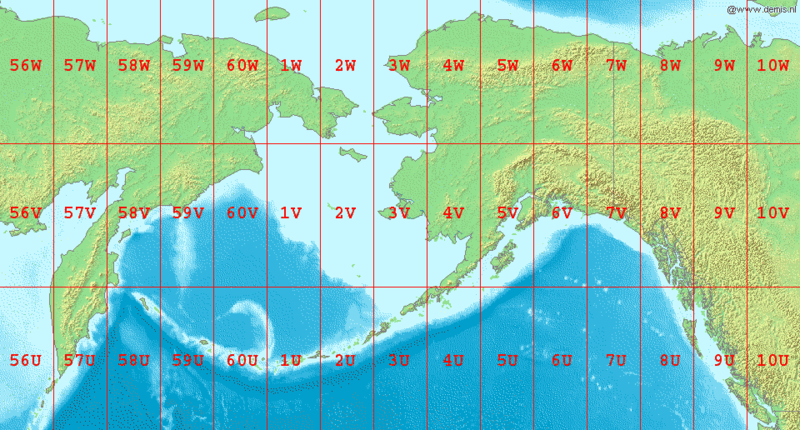
English: Map of en:Bering Sea, showing the latitude and longitude zones of the en:Universal Transverse Mercator coordinate system, from 56U to 10W.
National borders between Alaska, Canada, and the continental United States are also shown.
Bounding box West 150°, South 48°, East -120°, North 72°.
Center at 60°00′00″N 165°00′00″W / 60.00000°N 165.00000°W.
Αδειοδότηση
This image is in the public domain because it came from the site https://www.demis.nl/products/web-map-server/examples/ and was released by the copyright holder. Permission is granted to copy, distribute and/or modify this map since it is based on free of copyright images from: www.demis.nl. See also approval email on de.wp and its clarification.
|
| This work has been released into the public domain by its copyright holder, www.demis.nl. This applies worldwide. Σε ορισμένες χώρες αυτό μπορεί να μην είναι νομικά εφικτό. Αν ναι: www.demis.nl Παραχωρώ σε οποιονδήποτε το δικαίωμα να χρησιμοποιήσει αυτό το έργο "για οποιονδήποτε σκοπό", χωρίς κανέναν όρο, εκτός και αν τέτοιοι όροι τίθενται από την νομοθεσία
|
Ιστορικό αρχείου
Κλικάρετε σε μια ημερομηνία/ώρα για να δείτε το αρχείο όπως εμφανιζόταν εκείνη τη στιγμή.
| Ώρα/Ημερομ. | Μικρογραφία | Διαστάσεις | Χρήστης | Σχόλια | |
|---|---|---|---|---|---|
| τελευταία | 07:04, 3 Σεπτεμβρίου 2006 | | 960 × 516 (103 KB) | LA2 | Map of en:Bering Sea, showing the latitude and longitude zones of the en:Universal Transverse Mercator coordinate system, from 56U to 10W. National borders between Alaska, Canada, and the continental United States are also shown. Bounding box W |
Συνδέσεις αρχείου
Τα παρακάτω λήμματα συνδέουν σε αυτό το αρχείο:
Καθολική χρήση αρχείου
Τα ακόλουθα άλλα wiki χρησιμοποιούν αυτό το αρχείο:
- Χρήση σε ar.wikipedia.org
- Χρήση σε ast.wikipedia.org
- Χρήση σε da.wikipedia.org
- Χρήση σε en.wikipedia.org
- Χρήση σε es.wikipedia.org
- Χρήση σε fa.wikipedia.org
- Χρήση σε gv.wikipedia.org
- Χρήση σε hr.wikipedia.org
- Χρήση σε hu.wikipedia.org
- Χρήση σε id.wikipedia.org
- Χρήση σε it.wikipedia.org
- Χρήση σε kk.wikipedia.org
- Χρήση σε la.wikipedia.org
- Χρήση σε ml.wikipedia.org
- Χρήση σε my.wikipedia.org
- Χρήση σε nl.wikipedia.org
- Χρήση σε nn.wikipedia.org
- Χρήση σε pa.wikipedia.org
- Χρήση σε pl.wikipedia.org
- Χρήση σε sr.wikipedia.org
- Χρήση σε ta.wikipedia.org
- Χρήση σε th.wikipedia.org
- Χρήση σε tr.wikipedia.org
- Χρήση σε ur.wikipedia.org
- Χρήση σε yi.wikipedia.org