Αρχείο:Map of USA highlighting Sun Belt.png
Map_of_USA_highlighting_Sun_Belt.png (280 × 183 εικονοστοιχεία, μέγεθος αρχείου: 40 KB, τύπος MIME: image/png)
|
|
Αυτό το αρχείο και η περιγραφή του προέρχονται από το Wikimedia Commons. Οι πληροφορίες από την σελίδα περιγραφής του εκεί εμφανίζονται παρακάτω. |
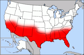
Public domain map courtesy of The General Libraries, The University of Texas at Austin, modified (by • Benc • 00:36, 13 Aug 2004 (UTC) to highlight regions.
Originally uploaded onto English Wikipedia 00:36, 13 August 2004 by Benc
English: This map come from the map collection of University of Texas, specifically from: [{{{url}}} {{{title}}}, from {{{origin}}}]. It is in the public domain (http://www.lib.utexas.edu/maps/faq.html#3.html).
Français : Cette carte est issue issu de la collection de cartes de l'université du Texas et plus précisément de celle-ci : [{{{url}}} {{{title}}}, from {{{origin}}}]. Elle se trouve dans dans le domaine public (http://www.lib.utexas.edu/maps/faq.html#3.html).
Nederlands: Deze afbeelding is afkomstig uit de kaartencollectie van de University of Texas. Deze kaarten bevinden zich in het publiek domein (http://www.lib.utexas.edu/maps/faq.html#3.html).
|
|
Αυτό το έργο είναι κοινό κτήμα στη χώρα προέλευσής του και άλλες χώρες και περιοχές όπου η διάρκεια πνευματικών δικαιωμάτων είναι όσο η ζωή του δημιουργού και μέχρι 70 χρόνια μετά ή λιγότερο.
| |
| Αυτό το αρχείο έχει χαρακτηριστεί ως απαλλαγμένο από γνωστούς περιορισμούς βάσει της νομοθεσίας περί πνευματικής ιδιοκτησίας, περιλαμβανομένων όλων των συναφών και συγγενικών δικαιωμάτων. | |
Ιστορικό αρχείου
Κλικάρετε σε μια ημερομηνία/ώρα για να δείτε το αρχείο όπως εμφανιζόταν εκείνη τη στιγμή.
| Ώρα/Ημερομ. | Μικρογραφία | Διαστάσεις | Χρήστης | Σχόλια | |
|---|---|---|---|---|---|
| τελευταία | 17:41, 27 Σεπτεμβρίου 2006 | | 280 × 183 (40 KB) | Mr Bullitt~commonswiki | Public domain map courtesy of [http://www.lib.utexas.edu/ The General Libraries, The University of Texas at Austin], modified (by • Benc • 00:36, 13 Aug 2004 (UTC)) to highlight regions. Originally uploaded |
Συνδέσεις αρχείου
Δεν υπάρχουν σελίδες που συνδέουν σε αυτό το αρχείο.
Καθολική χρήση αρχείου
Τα ακόλουθα άλλα wiki χρησιμοποιούν αυτό το αρχείο:
- Χρήση σε en.wikipedia.org
- Χρήση σε fr.wikipedia.org