Αρχείο:Sandy 2012-10-29 1515Z.png

Μέγεθος αυτής της προεπισκόπησης: 800 × 450 εικονοστοιχεία . Άλλες αναλύσεις: 320 × 180 εικονοστοιχεία | 640 × 360 εικονοστοιχεία | 1.024 × 576 εικονοστοιχεία | 1.280 × 720 εικονοστοιχεία | 1.920 × 1.080 εικονοστοιχεία.
Εικόνα σε υψηλότερη ανάλυση (1.920 × 1.080 εικονοστοιχεία, μέγεθος αρχείου: 2,07 MB, τύπος MIME: image/png)
|
|
Αυτό το αρχείο και η περιγραφή του προέρχονται από το Wikimedia Commons. Οι πληροφορίες από την σελίδα περιγραφής του εκεί εμφανίζονται παρακάτω. |
Σύνοψη
| Περιγραφή |
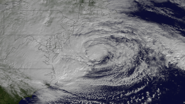
English: Hurricane Sandy, with winds of 90 mph and heavy rains, is creating dangerous flooding conditions all along the Northeast U.S. from NC to New England. This NOAA GOES-13 satellite image taken on October 29, 2012 shows the storm as it is centered off of Maryland and Virginia. The storm is heading in a northwestern direction towards the Delaware and southern New Jersey coast. |
| Ημερομηνία | |
| Πηγή | http://www.nnvl.noaa.gov/MediaDetail2.php?MediaID=1223&MediaTypeID=1 |
| Δημιουργός | The National Oceanic and Atmospheric Administration |
Αδειοδότηση
This image is in the public domain because it contains materials that originally came from the U.S. National Oceanic and Atmospheric Administration, taken or made as part of an employee's official duties.
|
Ιστορικό αρχείου
Κλικάρετε σε μια ημερομηνία/ώρα για να δείτε το αρχείο όπως εμφανιζόταν εκείνη τη στιγμή.
| Ώρα/Ημερομ. | Μικρογραφία | Διαστάσεις | Χρήστης | Σχόλια | |
|---|---|---|---|---|---|
| τελευταία | 08:27, 9 Απριλίου 2018 | | 1.920 × 1.080 (2,07 MB) | A1Cafel | remove logo |
| 20:22, 29 Οκτωβρίου 2012 |  | 1.920 × 1.080 (1,93 MB) | Supportstorm | {{Information |Description ={{en|1=Hurricane Sandy, with winds of 90 mph and heavy rains, is creating dangerous flooding conditions all along the Northeast U.S. from NC to New England. This NOAA GOES-13 satellite image taken on October 29, 2012 show... |
Συνδέσεις αρχείου
Τα παρακάτω λήμματα συνδέουν σε αυτό το αρχείο:
Καθολική χρήση αρχείου
Τα ακόλουθα άλλα wiki χρησιμοποιούν αυτό το αρχείο:
- Χρήση σε fr.wikipedia.org
- Χρήση σε sr.wikinews.org