Αρχείο:Spread sugarcane.JPG
Spread_sugarcane.JPG (483 × 248 εικονοστοιχεία, μέγεθος αρχείου: 16 KB, τύπος MIME: image/jpeg)
|
|
Αυτό το αρχείο και η περιγραφή του προέρχονται από το Wikimedia Commons. Οι πληροφορίες από την σελίδα περιγραφής του εκεί εμφανίζονται παρακάτω. |

|
This map image could be re-created using vector graphics as an SVG file. This has several advantages; see Commons:Media for cleanup for more information. If an SVG form of this image is available, please upload it and afterwards replace this template with
{{vector version available|new image name}}.
It is recommended to name the SVG file “Spread sugarcane.svg”—then the template Vector version available (or Vva) does not need the new image name parameter. |


Σύνοψη
| Περιγραφή |
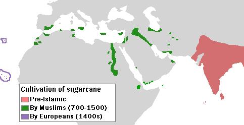
English: Author: User:Bless_sins.
Source: I saw this map in:
Use rationale: I made it myself. The template map was free-use.
(islands west of Africa, circled by violet lines) |
| Ημερομηνία | 10 Απριλίου 2008 (original upload date) |
| Πηγή |
Transferred from en.wikipedia to Commons by Teratornis using CommonsHelper.
Cambridge University Press. p. 16. |
| Δημιουργός | Bless sins at Αγγλικά Βικιπαίδεια |
Αδειοδότηση
- Είστε ελεύθερος:
- να μοιραστείτε – να αντιγράψετε, διανέμετε και να μεταδώσετε το έργο
- να διασκευάσετε – να τροποποιήσετε το έργο
- Υπό τις ακόλουθες προϋποθέσεις:
- αναφορά προέλευσης – Θα πρέπει να κάνετε κατάλληλη αναφορά, να παρέχετε σύνδεσμο για την άδεια και να επισημάνετε εάν έγιναν αλλαγές. Μπορείτε να το κάνετε με οποιοδήποτε αιτιολογήσιμο λόγο, χωρίς όμως να εννοείται με οποιονδήποτε τρόπο ότι εγκρίνουν εσάς ή τη χρήση του έργου από εσάς.
- παρόμοια διανομή – Εάν αλλάξετε, τροποποιήσετε ή δημιουργήσετε πάνω στο έργο αυτό, μπορείτε να διανείμετε αυτό που θα προκύψει μόνο υπό τους όρους της ίδιας ή συμβατής άδειας με το πρωτότυπο.
Καταγραφές ανεβασμάτων πρωτότυπου αρχείου
- 2008-04-10 04:58 Bless sins 483×248× (16233 bytes) Author: User:Bless_sins. Source: I saw this map in: Watson, Andrew. ''Agricultural innovation in the early Islamic world''. [[Cambridge University Press]]. p. 16. Looking at it I drew an approximation. Use rationale: I made it myself. The template map was
Ιστορικό αρχείου
Κλικάρετε σε μια ημερομηνία/ώρα για να δείτε το αρχείο όπως εμφανιζόταν εκείνη τη στιγμή.
| Ώρα/Ημερομ. | Μικρογραφία | Διαστάσεις | Χρήστης | Σχόλια | |
|---|---|---|---|---|---|
| τελευταία | 05:32, 7 Οκτωβρίου 2009 | | 483 × 248 (16 KB) | File Upload Bot (Magnus Manske) | {{BotMoveToCommons|en.wikipedia|year={{subst:CURRENTYEAR}}|month={{subst:CURRENTMONTHNAME}}|day={{subst:CURRENTDAY}}}} {{Information |Description={{en|Author: User:Bless_sins. Source: I saw this map in: Watson, Andrew. ''Agricultural innovation in the ea |
Συνδέσεις αρχείου
Τα παρακάτω λήμματα συνδέουν σε αυτό το αρχείο:
Καθολική χρήση αρχείου
Τα ακόλουθα άλλα wiki χρησιμοποιούν αυτό το αρχείο:
- Χρήση σε cs.wikipedia.org
- Χρήση σε en.wikipedia.org
- Χρήση σε eo.wikipedia.org
- Χρήση σε es.wikipedia.org
- Χρήση σε eu.wikipedia.org
- Χρήση σε fr.wikipedia.org
- Χρήση σε he.wikipedia.org
- Χρήση σε hr.wikipedia.org
- Χρήση σε hu.wikipedia.org
- Χρήση σε ja.wikipedia.org
- Χρήση σε kn.wikipedia.org
- Χρήση σε ko.wikipedia.org
- Χρήση σε pa.wikipedia.org
- Χρήση σε pnb.wikipedia.org
- Χρήση σε pt.wikipedia.org
- Χρήση σε sh.wikipedia.org
- Χρήση σε sr.wikipedia.org