Αρχείο:St helens map showing 1980 eruption deposits.png
Δεν διατίθεται υψηλότερη ανάλυση.
St_helens_map_showing_1980_eruption_deposits.png (702 × 527 εικονοστοιχεία, μέγεθος αρχείου: 18 KB, τύπος MIME: image/png)
|
|
Αυτό το αρχείο και η περιγραφή του προέρχονται από το Wikimedia Commons. Οι πληροφορίες από την σελίδα περιγραφής του εκεί εμφανίζονται παρακάτω. |
Σύνοψη
| Περιγραφή | |
| Πηγή | USGS |
| Δημιουργός | USGS |

|
This geology image could be re-created using vector graphics as an SVG file. This has several advantages; see Commons:Media for cleanup for more information. If an SVG form of this image is available, please upload it and afterwards replace this template with
{{vector version available|new image name}}.
It is recommended to name the SVG file “St helens map showing 1980 eruption deposits.svg”—then the template Vector version available (or Vva) does not need the new image name parameter. |
Αδειοδότηση
This image is in the public domain in the United States because it only contains materials that originally came from the United States Geological Survey, an agency of the United States Department of the Interior. For more information, see the official USGS copyright policy.
|
Καταγραφές ανεβασμάτων πρωτότυπου αρχείου
The original description page was here. All following user names refer to en.wikipedia.
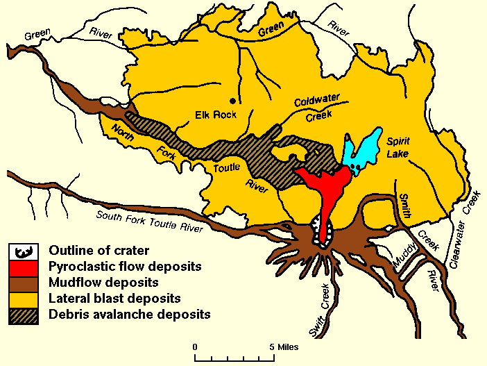
- 2007-12-27 01:18 Peteforsyth 702×527× (17938 bytes) replacing jpeg version, and cropping out extraneous text. Map of the area around Mount St. Helens which were affected by the May 18, 1980 eruption. North is to the top. [[USGS]] image from [http://vulcan.wr.usgs.gov/Volcanoes/MSH/SlideSet/ljt_slideset_
Ιστορικό αρχείου
Κλικάρετε σε μια ημερομηνία/ώρα για να δείτε το αρχείο όπως εμφανιζόταν εκείνη τη στιγμή.
| Ώρα/Ημερομ. | Μικρογραφία | Διαστάσεις | Χρήστης | Σχόλια | |
|---|---|---|---|---|---|
| τελευταία | 18:18, 24 Μαΐου 2011 | | 702 × 527 (18 KB) | File Upload Bot (Magnus Manske) | {{BotMoveToCommons|en.wikipedia|year={{subst:CURRENTYEAR}}|month={{subst:CURRENTMONTHNAME}}|day={{subst:CURRENTDAY}}}} {{Information |Description={{en|replacing jpeg version, and cropping out extraneous text. Map of the area around Mount St. Helens whic |
Συνδέσεις αρχείου
Τα παρακάτω λήμματα συνδέουν σε αυτό το αρχείο:
Καθολική χρήση αρχείου
Τα ακόλουθα άλλα wiki χρησιμοποιούν αυτό το αρχείο:
- Χρήση σε bg.wikipedia.org
- Χρήση σε cs.wikipedia.org
- Χρήση σε en.wikipedia.org
- Χρήση σε fa.wikipedia.org
- Χρήση σε id.wikipedia.org
- Χρήση σε km.wikipedia.org
- Χρήση σε mk.wikipedia.org
- Χρήση σε ms.wikipedia.org
- Χρήση σε ne.wikipedia.org
- Χρήση σε nl.wikipedia.org
- Χρήση σε pt.wikipedia.org
- Χρήση σε simple.wikipedia.org
- Χρήση σε sr.wikipedia.org
- Χρήση σε te.wikipedia.org
- Χρήση σε th.wikipedia.org
- Χρήση σε tr.wikipedia.org
- Χρήση σε uk.wikipedia.org
- Χρήση σε uz.wikipedia.org
- Χρήση σε vi.wikipedia.org
- Χρήση σε zh.wikipedia.org