Αρχείο:USGS-PlanetMars-TopographicalMap.png

Μέγεθος αυτής της προεπισκόπησης: 800 × 367 εικονοστοιχεία . Άλλες αναλύσεις: 320 × 147 εικονοστοιχεία | 640 × 294 εικονοστοιχεία | 1.024 × 470 εικονοστοιχεία | 1.280 × 587 εικονοστοιχεία | 2.560 × 1.174 εικονοστοιχεία | 10.292 × 4.720 εικονοστοιχεία.
Εικόνα σε υψηλότερη ανάλυση (10.292 × 4.720 εικονοστοιχεία, μέγεθος αρχείου: 6,72 MB, τύπος MIME: image/png)
|
|
Αυτό το αρχείο και η περιγραφή του προέρχονται από το Wikimedia Commons. Οι πληροφορίες από την σελίδα περιγραφής του εκεί εμφανίζονται παρακάτω. |
Σύνοψη
| Περιγραφή |
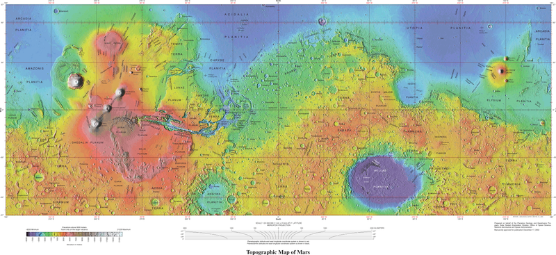
English: USGS - Planet Mars - Topographical Map - 1-24-2005 - Geologic Investigations Series I-2782 These maps are based on data from the Mars Orbiter Laser Altimeter (MOLA; Smith and others, 2001), an instrument on NASA’s Mars Global Surveyor (MGS) spacecraft (Albee and others, 2001). The image used for the base of this map represents more than 600 million measurements gathered between 1999 and 2001, adjusted for consistency (Neumann and others, 2001, 2003) and converted to planetary radii. These have been converted to elevations above the areoid as determined from a martian gravity field solution GMM-2B (Lemoine and others, 2001), truncated to degree and order 50, and oriented according to current standards (see below). The average accuracy of each point is originally ~100 meters in horizontal position and ~1 meter in radius (Neumann and others, 2001). However, the total elevation uncertainty is at least ±3 m due to the global error in the areoid (±1.8 meters according to Lemoine and others [2001]) and regional uncertainties in its shape (G.A. Neumann, written commun., 2002). The measurements were converted into a digital elevation model (DEM; G.A. Neumann, written commun., 2002; Neumann and others, 2001; Smith and others 2001) using Generic Mapping Tools software (Wessel and Smith, 1998), with a resolution of 0.015625 degree per pixel or 64 pixels per degree. In projection, the pixels are 926.17 meters in size at the equator. Data are very sparse near the two poles (above 87° north and below 87° south latitude) because these areas were sampled by only a few off-nadir altimetry tracks. Gaps between tracks of 1–2 km are common, and some gaps of up to 12 km occur near the equator. DEM points located in these gaps in MOLA data were filled by interpolation. |
| Ημερομηνία | |
| Πηγή | https://pubs.usgs.gov/imap/i2782/; https://pubs.usgs.gov/imap/i2782/i2782_sh1.pdf |
| Δημιουργός | U.S. Geological Survey |
| άλλες εκδόσεις |
|


Αδειοδότηση
This image is in the public domain in the United States because it only contains materials that originally came from the United States Geological Survey, an agency of the United States Department of the Interior. For more information, see the official USGS copyright policy.
|
| Αυτό το αρχείο είναι κοινό κτήμα γιατί δημιουργήθηκε από την NASA. Η πολιτική πνευματικής ιδιοκτησίας της NASA δηλώνει ότι «Το υλικό της NASA δεν προστατεύεται από copyright εκτός αν αναφέρεται». (Σελίδα με την πολιτική πνευματικής ιδιοκτησίας της NASA ή Πολιτική Χρήσης Εικόνων του JPL). | ||
 |
Προσοχή:
|
Ιστορικό αρχείου
Κλικάρετε σε μια ημερομηνία/ώρα για να δείτε το αρχείο όπως εμφανιζόταν εκείνη τη στιγμή.
| Ώρα/Ημερομ. | Μικρογραφία | Διαστάσεις | Χρήστης | Σχόλια | |
|---|---|---|---|---|---|
| τελευταία | 18:11, 4 Οκτωβρίου 2021 | | 10.292 × 4.720 (6,72 MB) | Cherurbino | same 256 clr, larger size + legend |
| 00:19, 16 Μαΐου 2019 |  | 7.245 × 3.204 (11,38 MB) | Huntster | Crop from original, manually trim out right side text, push title text up a bit. | |
| 02:14, 15 Μαΐου 2019 |  | 3.472 × 1.544 (7,43 MB) | Drbogdan | User created page with UploadWizard |
Συνδέσεις αρχείου
Τα παρακάτω λήμματα συνδέουν σε αυτό το αρχείο:
Καθολική χρήση αρχείου
Τα ακόλουθα άλλα wiki χρησιμοποιούν αυτό το αρχείο:
- Χρήση σε en.wikipedia.org
- Χρήση σε hr.wikipedia.org
- Χρήση σε ru.wikipedia.org
- Χρήση σε vi.wikipedia.org