Αρχείο:West-Slavic peoples until 1125.jpg

Μέγεθος αυτής της προεπισκόπησης: 442 × 600 εικονοστοιχεία . Άλλες αναλύσεις: 177 × 240 εικονοστοιχεία | 353 × 480 εικονοστοιχεία | 943 × 1.280 εικονοστοιχεία.
Εικόνα σε υψηλότερη ανάλυση (943 × 1.280 εικονοστοιχεία, μέγεθος αρχείου: 387 KB, τύπος MIME: image/jpeg)
|
|
Αυτό το αρχείο και η περιγραφή του προέρχονται από το Wikimedia Commons. Οι πληροφορίες από την σελίδα περιγραφής του εκεί εμφανίζονται παρακάτω. |
Σύνοψη
| Περιγραφή |
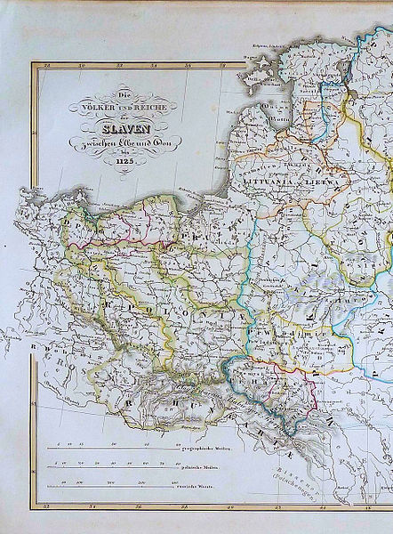
English: Map shows Kingdom of Poland (R. Poloniae) around 1125 - dark green borders - with its provinces: Greater Poland and Lesser Poland (yellow borders), Silesia, Masovia, Pomerania (with Gdańsk Pomerania - M: Gdansk). |
| Ημερομηνία | |
| Πηγή | Historisch Geographischer Handatlas, zweite Abtheilung, zweite Auflage, Justus Pertes |
| Δημιουργός | Dr. Karl von Spruner |
Αδειοδότηση
This media file is in the public domain in the United States. This applies to U.S. works where the copyright has expired, often because its first publication occurred prior to January 1, 1929, and if not then due to lack of notice or renewal. See this page for further explanation.
|
 | |
 |
This image might not be in the public domain outside of the United States; this especially applies in the countries and areas that do not apply the rule of the shorter term for US works, such as Canada, Mainland China (not Hong Kong or Macao), Germany, Mexico, and Switzerland. The creator and year of publication are essential information and must be provided. See Wikipedia:Public domain and Wikipedia:Copyrights for more details.
|
Ιστορικό αρχείου
Κλικάρετε σε μια ημερομηνία/ώρα για να δείτε το αρχείο όπως εμφανιζόταν εκείνη τη στιγμή.
| Ώρα/Ημερομ. | Μικρογραφία | Διαστάσεις | Χρήστης | Σχόλια | |
|---|---|---|---|---|---|
| τελευταία | 13:49, 8 Αυγούστου 2012 | | 943 × 1.280 (387 KB) | Opole.pl |
Συνδέσεις αρχείου
Τα παρακάτω λήμματα συνδέουν σε αυτό το αρχείο:
Καθολική χρήση αρχείου
Τα ακόλουθα άλλα wiki χρησιμοποιούν αυτό το αρχείο:
- Χρήση σε als.wikipedia.org
- Χρήση σε de.wikipedia.org
- Χρήση σε en.wikipedia.org
- Χρήση σε es.wikipedia.org
- Χρήση σε et.wikipedia.org
- Χρήση σε lv.wikipedia.org
- Χρήση σε nds-nl.wikipedia.org
- Χρήση σε sh.wikipedia.org
- Χρήση σε sl.wikipedia.org
- Χρήση σε sr.wikipedia.org