Nile_River_and_delta_from_orbit.jpg(700 × 550 εικονοστοιχεία, μέγεθος αρχείου: 85 KB, τύπος MIME: image/jpeg)

Σύνοψη

Περιγραφή

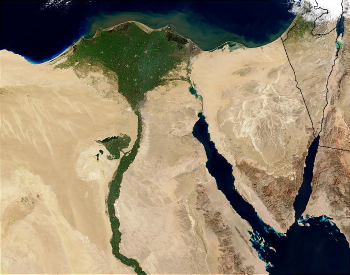
Nile River and delta from orbit Description: The Nile River and delta as seen from space by the MODIS sensor on the Terra satellite.

"Against the barren desert of northeastern Africa, the fertile valley of the Nile River runs northward through Egypt. In the higher-resolution images, the city of Cairo can be seen as a gray smudge right where the river widens into its broad fan-shaped delta. Other cities are dotted across the green landscape, giving it a speckled appearance. Where the Nile empties into the Mediterranean Sea (top) the waters are swirling with color, likely a mixture of sediment, organic matter, and possibly marine plant life. Farther west, the bright blue color of the water is likely less-organically rich sediment, perhaps sand.
"East of the delta lies the arid Sinai Peninsula, whose pointed tip is home to rugged mountains, some as high as 8,600 feet. The lattice work of pale lines marks the paths of ephemeral rivers. The Sinai Peninsula intrudes into the Red Sea. Farther east are Israel, Jordan, and Saudi Arabia. At top right is the disputed territory of the West Bank.
"In the false-color image, vegetation is bright green, water is dark blue or black, and clouds are light blue. It's interesting to notice that places that seem essentially arid, or desert-like in the true-color image in fact have a delicate layer of vegetation. For example, the central Sinai Peninsula, and most of Israel have a faint greenish tinge in the false-color images.
Ημερομηνία
Πηγή http://visibleearth.nasa.gov/view_rec.php?id=4927 [1]
Δημιουργός Jacques Descloitres, MODIS Rapid Response Team, NASA/sh
άλλες εκδόσεις Cuaggjacgacugvajgca

Salchicha

Αδειοδότηση

Public domain Αυτό το αρχείο είναι κοινό κτήμα γιατί δημιουργήθηκε από την NASA. Η πολιτική πνευματικής ιδιοκτησίας της NASA δηλώνει ότι «Το υλικό της NASA δεν προστατεύεται από copyright εκτός αν αναφέρεται». (Σελίδα με την πολιτική πνευματικής ιδιοκτησίας της NASA ή Πολιτική Χρήσης Εικόνων του JPL).
Προσοχή:
  • Η χρήση των λογότυπων της NASA, των εμβλημάτων και των διακριτικών της, περιορίζεται από τον αμερικάνικο νόμο 14 CFR 1221.
  • Ο ιστότοπος της NASA έχει μεγάλο αριθμό εικόνων από το Σοβιετικό διαστημικό πρόγραμμα και την Ρωσική Διαστημική Υπηρεσία καθώς και άλλες μη αμερικανικές διαστημικές υπηρεσίες. Αυτού του είδους οι εικόνες δεν είναι κατ' ανάγκην κοινά κτήματα.
  • Υλικό από το διαστημικό τηλεσκόπιο Hubble ενδέχεται να έχει πνευματικά δικαιώματα αν δεν προέρχεται ρητά από το STScI. [2]
  • Όλο το υλικό από την διαστημοσυσκευή SOHO έχει πνευματικά δικαιώματα και απαιτείται άδεια για εμπορική μη εκπαιδευτική χρήση. [3]
  • Οι εικόνες που προβάλλονται στον ιστότοπο Astronomy Picture of the Day (APOD) ενδέχεται να έχουν πνευματικά δικαιώματα [4]

Λεζάντες

Δεν ορίστηκε λεζάντα
Nile delta

Items portrayed in this file

απεικονίζει

Ιστορικό αρχείου

Κλικάρετε σε μια ημερομηνία/ώρα για να δείτε το αρχείο όπως εμφανιζόταν εκείνη τη στιγμή.

Ώρα/Ημερομ.ΜικρογραφίαΔιαστάσειςΧρήστηςΣχόλια
τελευταία22:47, 29 Νοεμβρίου 2004Μικρογραφία για την έκδοση της 22:47, 29 Νοεμβρίου 2004700 × 550 (85 KB)MschlindweinNile River and delta from orbit

Τα παρακάτω λήμματα συνδέουν σε αυτό το αρχείο:

Καθολική χρήση αρχείου

Τα ακόλουθα άλλα wiki χρησιμοποιούν αυτό το αρχείο:

Δείτε περισσότερη καθολική χρήση αυτού του αρχείου.