Αλβανόπολις
Για την αρμένικη πόλη, δείτε Αλβανόπολις (Αρμενία).
Συντεταγμένες: 41°28′31″N 19°46′35″E / 41.47528°N 19.77639°E
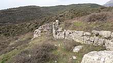
Η Αλβανόπολις[1][2] ήταν πόλη στην αρχαία Ρωμαϊκή Μακεδονία και πιο συγκεκριμένα στη Νέα Ήπειρο, πόλη των Αλβανών. Οι συγγραφείς του Barrington Atlas of the Greek and Roman World τοποθετούν την Αλβανόπολη στην θέση του σημερινού χωριού του Ζγκερδές, πλησίον της Κρούγια της Αλβανίας.[3][4] Η αρχαία πόλη πιθανώς να αντιστοιχεί με ύστερες αναφορές του οικισμού υπό την επωνυμία Άρβανον και Άλβανον στην διάρκεια του Μεσαίωνα, αν και δεν είναι ακόμη επιβεβαιωμένο κατά πόσο επρόκειτο για την ίδια τοποθεσία.[5] Το όνομα της πόλης αναφέρεται για πρώτη φορά το 150, σχεδόν 300 χρόνια έπειτα από την ρωμαϊκή κατάληψη της περιοχής.
| Αλβανόπολις | |
|---|---|
 | |
| Είδος | πόλη |
| Γεωγραφικές συντεταγμένες | 41°28′31″N 19°46′35″E |
| Χώρα | Αλβανία |
| δεδομένα (π) | |
Παραπομπές
Επεξεργασία- ↑ Ptolemy. «III.13(12).23». Geography.
- ↑ Smith, William, επιμ. (1854). «ILLYRICUM: 4. Race and National Character». Dictionary of Greek and Roman Geography.
Ptolemy is the earliest writer in whose works the name of the Albanians has been distinctly recognised. He mentions (3.13.23) a tribe called ALBANI (Ἀλβανοί) and a town ALBANOPOLIS (Ἀλβανόπολις), in the region lying to the E. of the Ionian sea; and from the names of places with which Albanopolis is connected, it appears clearly to have been in the S. part of the Illyrian territory, and in modern Albania. There are no means of forming a conjecture how the name of this obscure tribe came to be extended to so considerable a nation
. - ↑ Richard Talbert, Barrington Atlas of the Greek and Roman World, (ISBN 0-691-03169-X), Map 49 & notes.
- ↑ «Albanopolis». shqiperia.com. Αρχειοθετήθηκε από το πρωτότυπο στις 16 Ιουλίου 2011. Ανακτήθηκε στις 29 Μαρτίου 2010.
- ↑ Wilkes, J. J. (1992). The Illyrians. σελ. 279. ISBN 0-631-19807-5.
We cannot be certain that the Arbanon of Anna Comnena is the same as Albanopolis of the Albani, a place located on the map of Ptolemy
.
